Sagene is a borough of the city of Oslo, Norway. The area became part of the city of Oslo in 1859. The name Sagene itself is the plural of the Norwegian word for "saw", reflecting all the old industrial mechanical saws powered by the river Akerselva in this area in the 19th and early 20th centuries.

Grefsen is a neighbourhood in the city of Oslo, Norway.

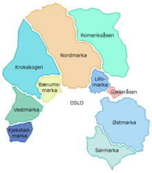
Marka is the name of the forested and hilly areas surrounding Oslo, Norway. It includes areas within the municipality of Oslo, but also large areas in Hole, Ringerike, Jevnaker, Lunner, Nittedal, Bærum, Asker, and other municipalities in Viken county. The name is actually just the finite form of mark 'woodland, forest'.

Hønefoss is a town and the administrative center of the municipality of Ringerike in Buskerud, Viken county, Norway. Hønefoss is an industrial center of inner Østlandet, containing several factories and other industry. As of 1 January 2022, Hønefoss had 16,547 inhabitants. Between 1852 and 1964, the town was an independent municipality.

Hadeland is a traditional district in the southeastern part of Norway. It is centered on the southern part of the large lake Randsfjorden in Innlandet and Viken counties. The district consists of the municipalities Gran in Innlandet county and Jevnaker and Lunner in Viken county. Hadeland occupies the area north of the hills of Nordmarka close to the Norwegian capital Oslo. The soil around the Randsfjorden is amongst the most fertile in Norway. Hadeland accounts for just 5% of the country's area, but it represents 13% of its agricultural land. Farmers harvest grains and potatoes. Pigs, dairy cattle, and horses are also bred at farms there.

Østmarka is a forested area to the east of Oslo and part of the congregation of woodland areas known as Oslomarka. The area is situated within the municipalities Oslo, Lørenskog, Rælingen, Ski and Enebakk. Østmarka is delimited to the west by populated areas of Oslo, to the north of communities of Skårer, Lørenskog and Rælingen and to the east by the lake Øyeren, to the south-east lies Enebakk and to the south-west Sørmarka, another forested area.
Events in the year 1986 in Norway.

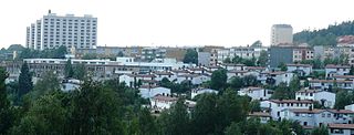
Skøyen is a neighborhood of Oslo, Norway. It is located in the western part of the city, in the borough of Ullern. The district has an increasing share of business activities, a development started in the 80s.

Lian is a recreational area located west of the city centre of Trondheim in Trøndelag county, Norway. It is situated on the border between the neighborhood of Byåsen and the forested area of Bymarka. The site came into popular recreational use in 1933 when the Gråkallen Line (Gråkallbanen) of the Trondheim Tramway was extended. Lian Station remains the terminus of Gråkallbanen.
Linderud is a neighborhood in Bjerke borough, Oslo, Norway. The area originally formed part of the estate of Linderud Manor.
Gjelleråsen is an area which constitutes part of Oslomarka outside Oslo, Norway.
Lillomarka is an area located to the northeast of Oslo, Norway. It is a part of Oslomarka and serves as a popular recreational area. Lillomarka is bordered by Maridalen and Nordmarka in the west, Nittedal and Gjelleråsen in the east, the suburbs Bjerke and Grorud in the south and the Gjøvik rail line and Movatn in the north.

Bredtvet is a neighborhood in the borough of Bjerke in Oslo, Norway.

Krokskogen is a forested area which located outside of Oslo, Norway. It is a part of Oslomarka and is situated between Bærumsmarka, Vestmarka and Nordmarka.
Bærumsmarka is a forested recreational area located outside Oslo, Norway. The area constitutes part of Oslomarka and is bordered by Krokskogen and Nordmarka.

Katnosa is a regulated lake in Nordmarka, Norway bordering to the municipalities Lunner, Jevnaker and Ringerike. It drains through the river Katnoselva to the lakes Store Sandungen, Hakkloa, Bjørnsjøen and Skjærsjøen. It is regulated by the dam Katnosdammen from 1886. Katnosa is part of the Spålen–Katnosa Nature Reserve.
Spålen–Katnosa Nature Reserve is a nature reserve in Nordmarka, Norway.
Events in the year 1612 in Norway.

Skøyenparken is a park in the neighborhood of Skøyen in the borough of Ullern in Oslo, Norway.

Innlandet is a county in Norway. It was created on 1 January 2020 with the merger of the old counties of Oppland and Hedmark. The new county has an area of 52,113 square kilometres (20,121 sq mi), making it the largest county in Norway after Troms og Finnmark was split up in 2024.