Related Research Articles

Copenhagen is the capital and most populous city of Denmark. As of 1 January 2020, the city had a population of 794,128 with 632,340 in Copenhagen Municipality, 104,305 in Frederiksberg Municipality, 42,989 in Tårnby Municipality, and 14,494 in Dragør Municipality. It forms the core of the wider urban area of Copenhagen and the Copenhagen metropolitan area. Copenhagen is situated on the eastern coast of the island of Zealand; another portion of the city is located on Amager, and it is separated from Malmö, Sweden, by the strait of Øresund. The Øresund Bridge connects the two cities by rail and road.

Indre Østerbro, is one of the 15 administrative, statistical, and tax city districts ("bydele") comprising the municipality of Copenhagen, Denmark. It lies on the eastern edge of the municipality. It covers an area of 6.76 km², has a population of 46,095 and a population density of 6,817 per km².
Ydre Østerbro is an area in Copenhagen, Denmark. It is the part of the district of Østerbro located farthest from the City Centre. It lies on the northeast border of the municipality. It covers an area of 5.08 km2, has a population of 35,937 and a population density of 7,081 per km2.
Ydre Nørrebro is an area in Copenhagen, Denmark. It is the part of the district of Nørrebro located farthest from the City Centre. It covers an area of 2.10 km², has a population of 41,497 and a population density of 19,733 per km², making it the most densely populated district in Copenhagen and all of Denmark. Approximately 25% of the inhabitants are immigrants, in some areas the immigrants population is 50%. Many shops are run by Middle Eastern and South Asian immigrants which gives the area a very multi-ethnic atmosphere.

Vesterbro is one of the 15 administrative, statistical, and city tax districts (bydele) comprising the municipality of Copenhagen, Denmark. It covers an area of 3.76 km², and has a population of 51,466 and a population density of 13,688 per km².

Vanløse is one of the 10 official districts of Copenhagen, Denmark. It lies on the western border of the municipality. Vanløse covers an area of 6.69 km², and has a population of 36,115, making Vanløse the smallest district of Copenhagen, by population.
Brønshøj-Husum is one of the 10 official districts of Copenhagen, Denmark. The district is bisected by Frederikssundsvej and consists mainly of vast areas of single family detached homes. It lies on the northwest border of the municipality. It covers an area of 8.73 km², has a population of 39,588. The district, now a quiet suburban area, has developed around the two old villages of Brønshøj and Husum.
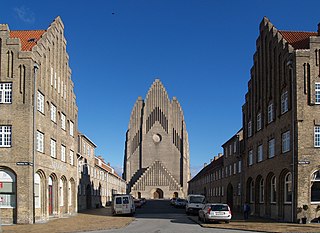
Bispebjerg, more commonly referred to as Nordvest , is one of the 10 official districts of Copenhagen, Denmark. Located on the northern border of the municipality, it covers an area of 5.39 km² and a population of 40,033. More specifically, Bispebjerg refers to a smaller neighbourhood within the district, located on the Bispebjerg Hill from which it takes its name.
DBU Copenhagen is the local governing body for association football and futsal in Copenhagen, Denmark. They are responsible for the governance and development of men's and women's football at all levels in the region. DBU Copenhagen is a member of the Union of Local Football Associations in Denmark (FLU) under the Danish Football Association (DBU) and National Olympic Committee and Sports Confederation of Denmark (DIF). The headquarters is at the Svanemølleanlægget at Østerbro after previously being located the national football stadium. Clubs situated in the municipalities of Copenhagen, Frederiksberg, Gentofte, Tårnby and Dragør can be accepted as members of DBU Copenhagen. Due to historical reasons a number of older clubs from other municipalities are also member of the association. In 2015 the association consisted of 150 clubs and 39,160 members with the oldest Danish association football club Kjøbenhavns Boldklub (KB) being the largest club membership-wise only surpassed by Brøndbyernes Idrætsforening on a national level.

Copenhagen Municipality, also known in English as the Municipality of Copenhagen, located in the Capital Region of Denmark, is the largest of the four municipalities that constitute the City of Copenhagen, the other three being Dragør, Frederiksberg, and Tårnby. The Municipality of Copenhagen constitutes the historical city center and the majority of its landmarks. It is the most populous in the country with a population of 637,936 inhabitants, and covers 86.4 square kilometres (33.4 sq mi) in area,. Copenhagen Municipality is located at the Zealand and Amager islands and totally surrounds Frederiksberg Municipality on all sides. The strait of Øresund lies to the east. The city of Copenhagen has grown far beyond the municipal boundaries from 1901, when Frederiksberg Municipality was made an enclave within Copenhagen Municipality.
Districts of Copenhagen are often based on informal designations based on historic origins, often with alternative names and loosely defined boundaries. Copenhagen Municipality is divided into 10 official administrative districts but they often comprise areas of a heterogeneous character which are colegually not seen as one district. Some districts have earlier been official subdivisions and thus have semi-official boundaries. Copenhagen postal code designations often correspond to district boundaries but in some cases differ from them, as an example parts of the city centre has the postal code København V which is generally associated with Vesterbro.
Ishøj Gymnasium was a secondary school located in Ishøj near Copenhagen, Denmark.

An urban district is the name used for urban or municipality districts in some of the larger municipalities of Denmark. The term is not strictly defined, but is usually bigger than a quarter or a city block.
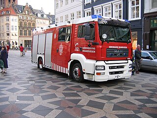
The Greater Copenhagen Fire Department forms the largest municipal fire brigade in Denmark with more than 1000 employees, this includes firefighters, ambulance personnel, administration and service workers, workers in prevention.
Borups Allé is a major artery in the northwestern part of inner Copenhagen, Denmark. The 3.2 km long street runs from Jagtvej at Nuuks Plads in the southeast to Bellahøj in the northwest. Just before Hulgårdsvej, part of Ring 2, Borups Allé is joined by Bispeengbuen, an elevated road section that connects it to Åboulevard-Ågade and H. C. Andersens Boulevard in the city centre. The rest of Borups Allé is the first leg of the National Road 16, part of the Danish national road network. It continues as a six-lane road to Frederikssundsvej where it becomes Hareskovvej and later the Hillerød Motorway at Utterslev Mose.

Copenhagen Technical College is a school of secondary education in Copenhagen, Denmark. The school offers educational programmes within the technical sciences on a secondary level to post-primary youth, Higher Technical Examination Programme (HTX), and supplementary courses for adults seeking to maintain qualifications (AMU). It is an independent self-owning institution under the Danish state, managed by a board composed of members from the business community in conjunction with a rector that oversees day-to-day operations. It occupies nine locations in the Greater Copenhagen area with the headquarters being located in Valby.
Tagensvej is a major street in the northwestern part of inner Copenhagen, Denmark. It runs from Blegdamsvej on the border between Nørrebro and Østerbro in the southeast to Frederiksborgvej and Bispebjerg Cemetery in the northwest.

Jagtvej is a major artery in the Nørrebro and Østerbro districts of Copenhagen, Denmark. It runs from Agade on the border with Frederiksberg in the southwest to Østerbrogade in the northeast, linking Falkoner Allé with Strandboulevarden. The street passes Assistens Cemetery, University of Copenhagen's North Campus and Fælled Park.
Constituencies are used for elections to the Folketing, the national parliament of Denmark. Denmark proper is divided into 10 constituencies largely corresponding to the Provinces of Denmark, each electing multiple members using open-list proportional representation. Those constituencies are then divided into 92 opstillingskredse which mainly serve the purpose of nominating candidates, but historically functioned as single-member constituencies electing one member using plurality voting.
References
- 1 2 3 4 5 6 Radio broadcast 2400 NV, sent 2011-01-31 20:03 on DR P1 in Danish
- ↑ "PNR1: Befolkningen efter område (postnumre) (AFSLUTTET)" [Population by area (postal codes) (COMPLETED)] (in Danish). Statistics Denmark.
- ↑ "Kvartervandring i Nordvestkvarteret] af Lokalhistorisk Arkiv Bispebjerg-Nordvest" [Area hike in Nordvest by the Bispebjerg-Nordvest local historic archives](PDF) (in Danish).
- ↑ "Kvarterløft - Rumlig modernisering of social rummelighed, rapport af Axel R. Kristiansen og Jørgen Bang, Roskilde Universitets Center" [Area improvements - open minded modernization and social tolerance, report by Axel R. Kristiansen and Jørgen Bangm, Roskilde University] (in Danish). Archived from the original on 2013-11-09. Retrieved 2013-12-25.
- ↑ "Arkark.dk: Emaljehaven".
- ↑ "Go Green Copenhagen: Rødkilde Nature Playground".
- ↑ "Lemming-Eriksson: Nordvestparken" [Lemming-Eriksson: The North West park] (in Danish).
- ↑ "2400 NV: Lyt til stedets stemmer" [2400 NV: Listen to the areas voices] (in Danish).
- 1 2 3 Theimann, Per (2013-05-04). "Det rette postnummer er guld værd" [The right postal code is worth a lot] (in Danish). Politiken.
- ↑ "Dagsorden for ordinært mode tirsdag den 16. januar 2001 i Københavns kommunes økonomiudvalg" [Agenda for ordinary meeting in Copenhagen municipality's fiscal board on 2001-01-16] (in Danish).
- ↑ "Folkesundhed i Norrebro og Nordvest" [Public health in Norrebro and Nordvest] (in Danish).
- ↑ "Forebyggelsescentrene Nørrebro-Nordvest" [Prevention centres in Nørrebro and Nordvest] (in Danish).
- ↑ "Udviklingsplan Nørrebro (TMF 129) af Københavns Kommune" [Development plan for Norrebro (TMF 129) by Copenhagen municipality] (in Danish).