Nordwestuckermark

Last updated
Nordwestuckermark
Wappen Nordwestuckermark.png
Location of Nordwestuckermark within Uckermark district
Nordwestuckermark in UM.png
Germany adm location map.svg
Red pog.svg
Nordwestuckermark
Brandenburg location map.svg
Red pog.svg
Nordwestuckermark
Coordinates: 53°23′N13°40′E / 53.383°N 13.667°E / 53.383; 13.667 Coordinates: 53°23′N13°40′E / 53.383°N 13.667°E / 53.383; 13.667
Country Germany
State Brandenburg
District Uckermark
Government
   Mayor (202028) Roland Klatt [1]
Area
  Total253.14 km2 (97.74 sq mi)
Elevation
80 m (260 ft)
Population
 (2020-12-31) [2]
  Total4,182
  Density17/km2 (43/sq mi)
Time zone UTC+01:00 (CET)
  Summer (DST) UTC+02:00 (CEST)
Postal codes
17291
Dialling codes 039852, 039859
Vehicle registration UM
Website www.gemeinde-nordwestuckermark.de

Nordwestuckermark is a municipality in the Uckermark district, in Brandenburg, Germany.

Contents

History and community structure

The community Nordwestuckermark was formed on 1 November 2001 from the previously independent municipalities Ferdinandshorst, Fürstenwerder, Gollmitz, Kraatz, Naugarten, Röpersdorf/Sternhagen, Schapow, Schönermark und Weggun (Amt Nordwestuckermark) and the municipality Holzendorf (department Prenzlau-Land).

The community Nordwestuckermark has the following districts:

  • Ferdinandshorst
  • Fürstenwerder
  • Gollmitz
  • Holzendorf
  • Kraatz
  • Naugarten
  • Röpersdorf/Sternhagen
  • Schapow
  • Schönermark (Nordwestuckermark)|Schönermark
  • Weggun

Demography

Nordwestuckermark: Population development
within the current boundaries (2020) [3]
YearPop.±% p.a.
1875 8,210    
1890 7,665−0.46%
1910 7,704+0.03%
1925 7,868+0.14%
1939 7,439−0.40%
1950 11,413+3.97%
1964 8,481−2.10%
YearPop.±% p.a.
1971 7,920−0.97%
1981 6,301−2.26%
1985 5,964−1.36%
1990 5,659−1.04%
1995 5,546−0.40%
2000 5,512−0.12%
2005 5,164−1.30%
YearPop.±% p.a.
2010 4,762−1.61%
2015 4,288−2.08%
2016 4,272−0.37%
2017 4,248−0.56%
2018 4,209−0.92%
2019 4,194−0.36%
2020 4,182−0.29%

See also

Related Research Articles

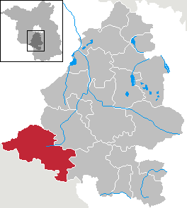
Oberhavel is a Kreis (district) in the northern part of Brandenburg, Germany. Its neighbouring districts are : Mecklenburg-Strelitz in Mecklenburg-Western Pomerania, the districts of Uckermark and Barnim, the Bundesland of Berlin, and the districts of Havelland and Ostprignitz-Ruppin.

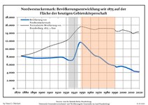
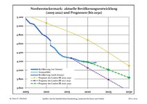
Uckermark is a Kreis (district) in the northeastern part of Brandenburg, Germany. Neighbouring districts are Barnim and Oberhavel, the districts Mecklenburgische Seenplatte and Vorpommern-Greifswald in Mecklenburg-Vorpommern, and to the east Poland. It is one of the largest districts of Germany areawise. The district is named after the historical region of Uckermark.

<span class="mw-page-title-main">Lychen</span> Town in Brandenburg, Germany

Lychen, also known as Flößerstadt, is a town in the Uckermark district, in Brandenburg, Germany. It is situated 24 kilometres (15 mi) southeast of Neustrelitz, and 12 kilometres (7.5 mi) east of Fürstenberg/Havel. This is the town where the thumbtack was created.

<span class="mw-page-title-main">Bestensee</span> Municipality in Brandenburg, Germany

Bestensee is a municipality in the district of Dahme-Spreewald in Brandenburg in Germany.

<span class="mw-page-title-main">Schulzendorf</span> Municipality in Brandenburg, Germany

Schulzendorf  is a municipality in the district of Dahme-Spreewald in Brandenburg in Germany.

<span class="mw-page-title-main">Röderland</span> Municipality in Brandenburg, Germany

Röderland is a municipality in the Elbe-Elster district, in Brandenburg, Germany.

Brieselang Municipality in Brandenburg, Germany

Brieselang is a municipality in the Havelland district, in Brandenburg, Germany.

Milower Land Municipality in Brandenburg, Germany

Milower Land is a municipality in the Havelland district, in Brandenburg, Germany.

<span class="mw-page-title-main">Letschin</span> Municipality in Brandenburg, Germany

Letschin is a municipality in the district of Märkisch-Oderland, in Brandenburg, Germany.

<span class="mw-page-title-main">Leegebruch</span> Municipality in Brandenburg, Germany

Leegebruch is a municipality in the Oberhavel district, in Brandenburg, Germany.

<span class="mw-page-title-main">Mühlenbecker Land</span> Municipality in Brandenburg, Germany

Mühlenbecker Land is a municipality in the Oberhavel district, in Brandenburg, Germany.

<span class="mw-page-title-main">Oberkrämer</span> Municipality in Brandenburg, Germany

Oberkrämer is a municipality in the Oberhavel district, in Brandenburg, Germany. An experimental farm of wind turbines existed between 1941 and 1945 on the 50 m high Matthias mountain in the area.

Seddiner See Municipality in Brandenburg, Germany

Seddiner See is a municipality in the Potsdam-Mittelmark district, in Brandenburg, Germany.

<span class="mw-page-title-main">Gumtow</span> Municipality in Brandenburg, Germany

Gumtow is a municipality in the Prignitz district, in Brandenburg, Germany.

<span class="mw-page-title-main">Karstädt</span> Municipality in Brandenburg, Germany

Karstädt is a municipality in the Prignitz district, in Brandenburg, Germany.

<span class="mw-page-title-main">Niederer Fläming</span> Municipality in Brandenburg, Germany

Niederer Fläming is a municipality in the Teltow-Fläming district of Brandenburg, Germany.

<span class="mw-page-title-main">Niedergörsdorf</span> Municipality in Brandenburg, Germany

Niedergörsdorf is a municipality in the Teltow-Fläming district of Brandenburg, Germany.

<span class="mw-page-title-main">Boitzenburger Land</span> Municipality in Brandenburg, Germany

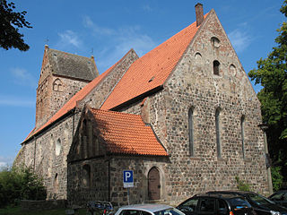
Boitzenburger Land is a municipality in the Uckermark district, in Brandenburg, Germany.

<span class="mw-page-title-main">Uckerland</span> Municipality in Brandenburg, Germany

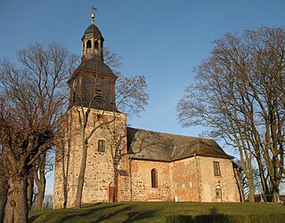
Uckerland is a municipality in the Uckermark district, in Brandenburg, Germany.

Amt Ziesar Amt in Brandenburg, Germany

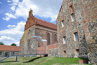
Amt Ziesar is an Amt in the district of Potsdam-Mittelmark, in Brandenburg, Germany. Its seat is in Ziesar.

References

  1. Landkreis Uckermark Wahl der Bürgermeisterin / des Bürgermeisters, accessed 4 July 2021.
  2. "Bevölkerung im Land Brandenburg nach amtsfreien Gemeinden, Ämtern und Gemeinden 31. Dezember 2020". Amt für Statistik Berlin-Brandenburg (in German). June 2021.
  3. Detailed data sources are to be found in the Wikimedia Commons.Population Projection Brandenburg at Wikimedia Commons