
The Normanby Fiveways is the intersection of five major roads to the north-east of the Brisbane central business district, Queensland, Australia.
The Normanby Fiveways is the intersection of five major roads to the north-east of the Brisbane central business district, Queensland, Australia.
The intersection consists of: [1]
The intersection takes its name from the Normanby Hotel on the corner of Musgrave Road and Kelvin Grove Road, which in turn was named in 1872 most likely after the recently appointed Governor of Queensland, George Phipps, 2nd Marquess of Normanby. [2]
The opening of the Grey Street Bridge (subsequently renamed the William Jolly Bridge) in 1932 had considerable impact on the Normanby Fiveways. The Grey Street Bridge was intended to relieve congestion on the Victoria Bridge and streets in the Brisbane central business district by allowing traffic between the suburbs on either side of the river to bypass the CBD. However, this created additional traffic into the Normanby Fiveways, which with its unusual five-way traffic movement turned the Normanby Fiveways into one of Brisbane's most dangerous intersections. [1] As a consequence, the introduction of traffic lights to manage traffic flow through the intersection was proposed in 1939. [3]
However, by 1952, the Norman Fiveways was now the most congested intersection in Brisbane yet no action had been taken to introduce traffic lights as the government did not have the funds. [4] Traffic lights and alternative strategies such as a subway to carry traffic going between Countess Street and Kelvin Grove Road continued to be proposed. [5] [6]
In 1953, tenders were called for the provision of traffic lights which would be the most complicated traffic light system in Brisbane, due to the peculiar five-way character of the intersection. [7] Meanwhile, a ban on paying police for overtime work meant the police who directed the traffic through the Normanby Fiveways finished work in the middle of the evening peak hour, creating traffic chaos. [8]
As at 2015, Petrie Terrace (the road) is one-way north into the Fiveways while Countess Street is one-way south, simplifying traffic movement through the (now traffic light controlled) intersection. The construction of the Inner City Bypass and the Go Between Bridge have removed much of the long-distance north-south traffic away from the Normanby Fiveways. The opening of the Legacy Tunnel in 2015 was intended to redirect a greater proportion of traffic to and from the western suburbs away from the Normanby Fiveways.

The William Jolly Bridge is a heritage-listed road bridge over the Brisbane River between North Quay in the Brisbane CBD and Grey Street in South Brisbane, within City of Brisbane, Queensland, Australia. It was designed by A E Harding Frew and built from 1928 to 1932 by M R Hornibrook Ltd.
Herston is an inner suburb of the City of Brisbane, Queensland, Australia. In the 2016 census, Herston had a population of 2,215 people.

West End is an inner southern suburb in the City of Brisbane, Queensland, Australia. At the 2016 census the suburb recorded a population of 9,474.
The Northern Busway is a bus-only road running north from the Brisbane central business district to the Royal Brisbane & Women's Hospital in Queensland, Australia. The first section of the busway opened on 23 February 2004 with one station at QUT Kelvin Grove. In December 2005, Normanby and Herston stations opened.

Indooroopilly is a western suburb in the City of Brisbane, Queensland, Australia. In the 2016 census, Indooroopilly had a population of 12,242 people.
The Brisbane central business district (CBD), officially gazetted as the suburb of Brisbane City and colloquially referred to as 'the city', is the heart of the state capital of Queensland, Australia. It is located on a point on the northern bank of the Brisbane River. The triangular shaped area is bounded by the Brisbane River to the east, south and west. The point, known at its tip as Gardens Point, slopes upward to the north-west where the city is bounded by parkland and the inner city suburb of Spring Hill to the north. The CBD is bounded to the north-east by the suburb of Fortitude Valley. To the west the CBD is bounded by Petrie Terrace, which in 2010 was reinstated as a suburb.

Petrie Terrace is an inner suburb of the City of Brisbane, Queensland, Australia.

Paddington is an inner suburb in the City of Brisbane, Queensland, Australia. In the 2016 census, Paddington had a population of 8,562 people.

Newmarket is an inner north-west suburb in the City of Brisbane, Queensland, Australia. It is an older, mostly residential suburb containing pre-war and post-war homes, including many fine examples of the Queenslander style of home. Over the last few years, some medium-density townhouses and unit blocks have appeared as well. In the 2016 census, Newmarket had a population of 4979 people.

Red Hill is an inner northern suburb in the City of Brisbane, Queensland, Australia. In the 2016 census, Red Hill had a population of 5,560 people.
Coronation Drive, popularly known as Coro Drive, is a road in Brisbane, Queensland which connects the Central Business District to the suburb of Toowong. It follows the Brisbane River from the Riverside Expressway, through the suburbs of Milton and Auchenflower, until it terminates in Toowong at Benson Road and High Street.
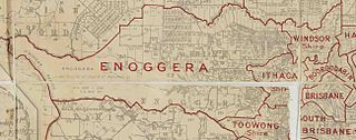
The Town of Ithaca is a former local government area of Queensland, Australia, located in inner western Brisbane.

Milton Road is an arterial road in Brisbane, Australia. It is currently signed as State Route 32 for its entire length. Milton Road is a major corridor for traffic between the Brisbane central business district and the western suburbs. It carried an average of 50,954 vehicles per day between July and December 2014.

Enoggera Creek is a stream that rises on the D'Aguilar Range and flows into the Brisbane River. The creek's headwaters form on the southern slopes of Mount Nebo in Brisbane Forest Park.
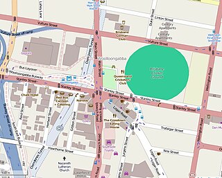
The Woolloongabba Fiveways is the intersection of 5 major roads at Woolloongabba, Brisbane, Queensland, Australia. The intersection gives its name to the surrounding commercial area.

Normanby Hotel is a heritage-listed hotel at 1 Musgrave Road, Red Hill, City of Brisbane, Queensland, Australia. It was designed by John B Nicholson and built in by Thomas Game. It was extended in 1917 to a design by George Henry Male Addison. It was added to the Queensland Heritage Register on 21 October 1992.

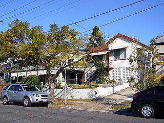
Warriston is a heritage-listed duplex at 6-8 Musgrave Road, Red Hill, City of Brisbane, Queensland, Australia. It was built c. 1886. It is also known as Berley Flats. It was added to the Queensland Heritage Register on 21 October 1992.

Kelvin Grove Fig Trees and Air Raid Shelter are heritage-listed trees and air raid shelter at 176 Kelvin Grove Road, Kelvin Grove, City of Brisbane, Queensland, Australia. It was built from c. 1909 to 1942. It was added to the Queensland Heritage Register on 31 May 2005.

Wickham Terrace is one of the historic streets of Brisbane, Queensland, Australia. It is known as the street of private medical specialists.
Waterworks Road is an 8.5 km (5.3 mi) arterial road in Brisbane, Queensland, Australia. It is currently signed as State Route 31 for its entire length. Waterworks Road transports traffic between the Brisbane central business district and western suburbs such as Red Hill, Ashgrove and The Gap.