
Molokai Airport, also known as Hoolehua Airport is a state-owned, public use airport located six nautical miles northwest of Kaunakakai, on the island of Molokai in Maui County, Hawaii, United States. It is the principal airport of the island. The largest plane to ever fly here regularly was a Boeing 737-200 jet, which seats 127 passengers.
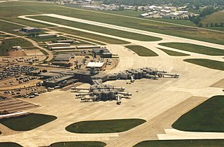
Green Bay–Austin Straubel International Airport is a county-owned public-use airport in Brown County, Wisconsin, United States, which serves Northeastern Wisconsin. It is the fourth busiest of eight commercial service airports in Wisconsin in terms of passengers served. The airport is located 7 nautical miles southwest of downtown Green Bay, in the village of Ashwaubenon.

North Bass Island is an island of the U.S. state of Ohio located in Lake Erie. A small unincorporated community, Isle Saint George, is on the island. The North Bass Island Post Office was established on May 25, 1864, and the name changed to Isle Saint George Post Office on March 2, 1874. The Isle Saint George ZIP code 43436 provides PO Box service. The island is equidistant to Port Clinton, OH and Kingsville, Ontario, Canada.

Sierra Vista Municipal Airport, a joint-use civil-military airport which shares facilities with Libby Army Airfield, is located on Fort Huachuca in Sierra Vista, a city and U.S. Army installation in Cochise County, Arizona, United States. The airport has three runways and one helipad. It is mostly used for military aviation for the surrounding military base.

Cleveland Burke Lakefront Airport is a public airport on the shore of Lake Erie, in the northeast part of downtown Cleveland, Ohio, United States. It's classified as a general aviation airport and is an FAA designated reliever to Cleveland Hopkins International Airport (CLE), which is Greater Cleveland's primary airport. In 2018, based on FAA data, Burke Lakefront was the seventh busiest airport in the state of Ohio. It is named after former Cleveland mayor and U.S. senator Thomas A. Burke.
Lansdowne Airport is a small, local airport on the East Side of Youngstown, Ohio, US near the Pennsylvania state line. Lansdowne Airport is a privately owned airport, located in an area known as the "Sharon Line" to locals, due to its proximity to a defunct train line that once ran from Youngstown to Sharon, right across the state line through the Steel Valleys.
Erie–Ottawa International Airport, is three miles east of Port Clinton, in Ottawa County, Ohio. It is owned by the Erie–Ottawa Airport Authority. The National Plan of Integrated Airport Systems for 2011–2015 categorized it as a general aviation facility. On November 9, 2013, Erie–Ottawa Airport obtained approval to handle international flights.
Middle Bass Island Airport is a public airport located on Middle Bass Island in Ottawa County, Ohio, United States. It is owned by the Put-in-Bay Township Port Authority.

Put-in-Bay Airport is a public airport located in Put-in-Bay on South Bass Island in Ottawa County, Ohio, United States. The approach to Runway 21 is complicated by Perry's Victory and International Peace Memorial, which is almost exactly in line with the runway; pilots are asked to respect special procedures to avoid the monument. The airport is located in the center of the southern half of the island.
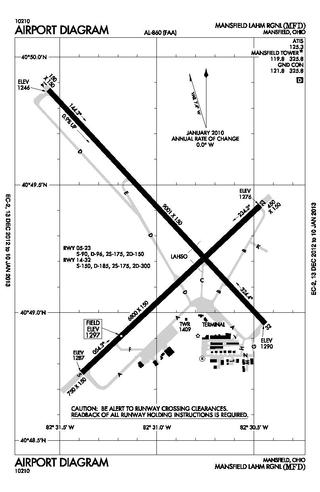
Mansfield Lahm Regional Airport is three miles (5 km) north of Mansfield, in Richland County, Ohio. By car the airport is an hour away from Cleveland and Columbus, near Interstate I-71, US Rt 30, State Route 13.

Greater Portsmouth Regional Airport is on State Route 335 in Minford, Ohio, 12 miles northeast of Portsmouth, in Scioto County, Ohio. It is owned by the Scioto County Airport Authority. The National Plan of Integrated Airport Systems for 2011–2015 categorized it as a general aviation facility.
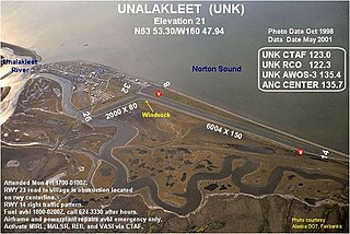
Unalakleet Airport is a state-owned public-use airport located one nautical mile (2 km) north of the central business district of Unalakleet, a city in the Nome Census Area of the U.S. state of Alaska.
Abrams Municipal Airport is a city-owned, public-use airport located two nautical miles (3.7 km) north of the central business district of Grand Ledge, a city in Eaton County, Michigan, United States. It is included in the Federal Aviation Administration (FAA) National Plan of Integrated Airport Systems for 2017–2021, in which it is categorized as a local general aviation facility.
Wheeling Ohio County Airport is a public airport serving Wheeling and Ohio County, West Virginia, United States. It is eight miles (13 km) northeast of downtown Wheeling and is owned by the Ohio County Commission.
Newark–Heath Airport is a public airport located in Heath, Ohio. It is three miles (4.8 km) southwest of the central business district of Newark, a city in Licking County, Ohio, United States. The airport was opened in 1930 by the city of Newark, and was transferred to the Licking County Regional Airport Authority in 1967. The airport currently has a McDonnell Douglas F-4C Phantom II S.N. 64–0683 on static display.

Sandusky County Regional Airport is a county-owned public-use airport located five nautical miles (9 km) southeast of the central business district of Fremont, a city in Sandusky County, Ohio, United States.
Ionia County Airport is a public airport located 3 mi (5 km) south of Ionia, Michigan. Opened in 1937, the airport is currently owned by Ionia County. It is included in the Federal Aviation Administration (FAA) National Plan of Integrated Airport Systems for 2017–2021, in which it is categorized as a local general aviation facility.
Northeast Ohio Regional Airport, owned and operated by the Ashtabula County Airport Authority, is a public-use airport in Ashtabula County, Ohio, United States, eight nautical miles (15 km) southeast of the central business district of the city of Ashtabula. Airport is located in Denmark Township near the Village of Jefferson, which is the County Seat of Ashtabula County. Located within minutes of Lake Erie and the intersection of major Interstates 90 (East/West) and 11 (North/South), the convenient location of the Northeast Ohio Regional Airport (HZY) makes it the perfect choice for both corporate and private travelers. The airport is located in the village of Jefferson, about 10 miles (16 km) south of Lake Erie. According to the FAA's National Plan of Integrated Airport Systems for 2009–2013, it is classified as a general aviation airport.
Hardin County Airport is a public airport located three miles southwest of Kenton, Ohio, United States. It is owned and operated by the Hardin County Airport Authority.

Morrow County Airport is a public airport located two miles southwest of Mount Gilead, Ohio, United States. It is owned and operated by the Morrow County Airport Authority.

