Related Research Articles

Cache Creek is a historic transportation junction and incorporated village 354 kilometres (220 mi) northeast of Vancouver in British Columbia, Canada. It is on the Trans-Canada Highway in the province of British Columbia at a junction with Highway 97. The same intersection and the town that grew around it was at the point on the Cariboo Wagon Road where a branch road, and previously only a trail, led east to Savona's Ferry on Kamloops Lake. This community is also the point at which a small stream, once known as Riviere de la Cache, joins the Bonaparte River.

Field is an unincorporated community of approximately 169 people located in the Kicking Horse River valley of southeastern British Columbia, Canada, within the confines of Yoho National Park. At an elevation of 1,256 m (4,121 ft), it is 27 km (17 mi) west of Lake Louise along the Trans-Canada Highway, which provides the only road access to the town. The community is named for Cyrus West Field of Transatlantic telegraph cable fame, who visited the area in 1884.

Canadian Pacific Hotels was a division of the Canadian Pacific Railway (CPR) that operated a series of resort hotels across Canada. Most of these hotels were originally built and operated by the railway's hotel department, while a few were acquired from Canadian National Hotels. Today, they are operated under the Fairmont name, and remain some of Canada's most exclusive hotels.

Hope is a commuter town and district municipality at the confluence of the Fraser and Coquihalla rivers in the province of British Columbia, Canada. Hope is at the eastern end of both the Fraser Valley and the Lower Mainland region, and is at the southern end of the Fraser Canyon. To the east over the Cascade Mountains is the Interior region, beginning with the Similkameen Country on the farther side of the Allison Pass in Manning Park. Located 154 kilometres (96 mi) east of Vancouver, Hope is at the southern terminus of the Coquihalla Highway and the western terminus of the Crowsnest Highway, locally known as the Hope-Princeton, where they merge with the Trans-Canada Highway. Hope is at the eastern terminus of Highway 7. As it lies at the eastern end of the Fraser Valley in the windward Cascade foothills, the town gets very high amounts of rain and cloud cover – particularly throughout the autumn and winter.

Lytton in British Columbia, Canada, sits at the confluence of the Thompson River and Fraser River on the east side of the Fraser. The location has been inhabited by the Nlaka'pamux people for over 10,000 years. It is one of the earliest locations settled by non-natives in the Southern Interior of British Columbia. It was founded during the Fraser Canyon Gold Rush of 1858–59, when it was known as "The Forks". The community includes the Village of Lytton and the surrounding community of the Lytton First Nation, whose name for the place is Camchin, also spelled Kumsheen.

Laidlaw is an unincorporated settlement in the Upper Fraser Valley region of British Columbia, Canada, located just west of the westernmost boundary of Hope, British Columbia on the south side of the Fraser River and along the Trans-Canada Highway.
Yale is an unincorporated town in the Canadian province of British Columbia.

The Fraser Valley Regional District (FVRD) is a regional district in British Columbia, Canada. Its headquarters are in the city of Chilliwack. The FVRD covers an area of 13,361.74 km² (5,159 sq mi). It was created by an amalgamation of the Fraser-Cheam Regional District and Central Fraser Valley Regional District and the portion of the Dewdney-Alouette Regional District from and including the District of Mission eastwards.
Spuzzum is an unincorporated settlement in British Columbia, Canada. Because it is on the Trans-Canada Highway, approximately 50 kilometres (31 mi) north of the community of Hope, it is often referred to as being "beyond Hope". Spuzzum was immortalized in the early 1980s by the band "Six Cylinder" in a song with the refrain "If you haven't been to Spuzzum, you ain't been anywhere."

The Cariboo Road was a project initiated in 1860 by the Governor of the Colony of British Columbia, James Douglas. It was a feat of engineering stretching from Fort Yale to Barkerville in the Canadian province of British Columbia through extremely hazardous canyon territory in the Interior of B.C.

The Fraser Canyon is a major landform of the Fraser River where it descends rapidly through narrow rock gorges in the Coast Mountains en route from the Interior Plateau of British Columbia to the Fraser Valley. Colloquially, the term "Fraser Canyon" is often used to include the Thompson Canyon from Lytton to Ashcroft, since they form the same highway route which most people are familiar with, although it is actually reckoned to begin above Williams Lake, British Columbia at Soda Creek Canyon near the town of the same name.

Fort Langley is a village community forming part of the Township of Langley in British Columbia, Canada. It has a population of 3,400. It is the home of Fort Langley National Historic Site, a former fur trade post of the Hudson's Bay Company. Lying on the Fraser River, Fort Langley is at the northern edge of the Township of Langley.

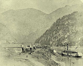
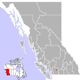
Boston Bar is an unincorporated town in the Fraser Canyon of the Canadian province of British Columbia.

Alexandra Bridge Provincial Park is a provincial park in British Columbia, Canada, located in the Fraser Canyon approximately two kilometres north of Spuzzum and 40 kilometres (25 mi) north of Hope.
Little Fort is a small community on the west bank of North Thompson River in the interior of British Columbia, Canada. It is some 93 kilometres (58 mi) north of Kamloops.

Clinton is a village in British Columbia, Canada, located approximately 40 km (25 mi) northwest of Cache Creek and 30 km south of 70 Mile House.
Spences Bridge is a community in the Canadian province of British Columbia, situated 35 km north east of Lytton and 44 km south of Ashcroft. In 1892, the population included 32 people of European ancestry and 130 First Nations people. There were five general stores, three hotels, one Church of England and one school. The principal industries are fruit growing and farming. The population as of 2016 is 99.
The Big Bend Gold Rush was a gold rush on the upper Columbia River in the Colony of British Columbia in the mid-1860s.
The British Columbia Interior, BC Interior or Interior of British Columbia, usually referred to only as the Interior, is one of the three main regions of the Canadian province of British Columbia, the other two being the Lower Mainland, which comprises the overlapping areas of Greater Vancouver and the Fraser Valley, and the Coast, which includes Vancouver Island and also including the Lower Mainland.
Boothroyd is a settlement in the Fraser Canyon region of British Columbia, just north of Boston Bar-North Bend. It sits on a flat, alluvial bench which is some of the only flat land in the Fraser Canyon. It was the site of a Cariboo Roadhouse, run by a man named Boothroyd. Later it was a camp for Canadian Pacific Railway chinese construction workers in 1882-4. Fruit farming and ranching also other activities.
References
- ↑ "North Bend" (Canada). Maplandia.com. Accessed May 2010.
- ↑ Akrigg, G.P.V.; Akrigg, Helen B. (1986), British Columbia Place Names (3rd, 1997 ed.), Vancouver: UBC Press, ISBN 0-7748-0636-2