North Carolina Highway 226 (NC 226) is a primary state highway in the U.S. state of North Carolina. Traveling north–south through Western North Carolina, it connects the cities and towns of Grover, Shelby, Marion, Spruce Pine and Bakersville. It also a scenic byway in the South Mountains area and connects with the summer colony of Little Switzerland, via NC 226A.
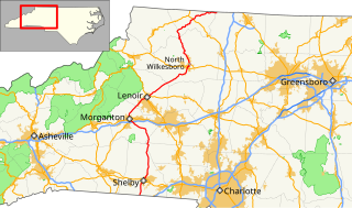
North Carolina Highway 18 (NC 18) is a primary state highway in the U.S. state of North Carolina. Traveling north–south through the Foothills region, it connects the cities of Shelby, Morganton, Lenoir, Wilkesboro and North Wilkesboro.

North Carolina Highway 87 (NC 87) is a primary state highway in the U.S. state of North Carolina. NC 87 begins in the Atlantic coastal town of Southport and crosses into Virginia at the Virginia state line five miles (8 km) north of Eden in Rockingham County. At 240 miles (390 km) in length, NC 87 is the second longest state highway in the U.S. state of North Carolina. Labeled as a north–south route, NC 87 travels along a relatively straight southeast–northwest path, connecting Cape Fear region with the Piedmont and connecting the cities of Fayetteville, Sanford, and Burlington.

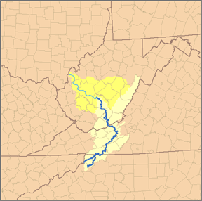
North Carolina Highway 28 (NC 28) is an 81.2-mile-long (130.7 km) primary state highway in the U.S. state of North Carolina. The highway runs north–south through the Nantahala National Forest in Western North Carolina.

North Carolina Highway 212 (NC 212) is a primary state highway in the U.S. state of North Carolina. The highway connects the White Rock community, through the Bald Mountains, in Madison County.

North Carolina Highway 143 (NC 143) is a primary state highway in the U.S. state of North Carolina. It runs from the Tennessee state line to NC 28, near the community of Stecoah. It is best known for its 18-mile (29 km) section of the Cherohala Skyway, shared with Tennessee State Route 165.

North Carolina Highway 68 (NC 68) is a north–south state highway in North Carolina. It serves as a connector between Interstate 40 (I-40)/ US 421 and Piedmont Triad International Airport. On its routing from Thomasville to Stokesdale, NC 68 passes through urban High Point, the western outskirts of Greensboro, and the town of Oak Ridge. The segment from just north of the I-40/US 421 interchange to Pleasant Ridge Road in Guilford County is a limited access freeway.

North Carolina Highway 268 (NC 268) is a primary state highway in the U.S. state of North Carolina. It connects many communities as it traverses through the northwestern North Carolina mountains and foothills.

North Carolina Highway 561 is a 100-mile-long (160 km) North Carolina state highway and a rural traffic artery connecting Louisburg and Ahoskie with many small-to-medium-sized towns in the Down East and Coastal Plain regions within minutes from the Virginia state line. NC 561 is a spur of NC 56, although the two highways never actually intersect.

North Carolina Highway 115 is a primary state highway in the U.S. state of North Carolina. It runs from U.S. Route 21 in North Charlotte north through Mecklenburg, Iredell and Wilkes counties. Its northern terminus is at its intersection with US 421 Business, NC 18 and NC 268 in North Wilkesboro.
U.S. Route 421 (US 421) traverses approximately 328 miles (528 km) across North Carolina; from Fort Fisher, on Pleasure Island between the Atlantic Ocean and Cape Fear River, to the Tennessee state line near the community of Zionville. The highway is nominally labeled "north" and "south" throughout North Carolina, though it really follows a general northwest-southeast path. The segments from Buies Creek to Sanford and from Greensboro to Boone are almost due east-west, with compass west corresponding to the signed north direction.

In the U.S. state of North Carolina U.S. Route 221 (US 221) is a north–south highway that travels through Western North Carolina. From Chesnee, South Carolina to Independence, Virginia, it connects the cities of Rutherfordton, Marion, Boone and Jefferson between the two out-of-state destinations. Its most memorable section, known as the Little Parkway Scenic Byway between Linville and Blowing Rock, offers area visitors a curvier alternative to the Blue Ridge Parkway and access to Grandfather Mountain.

North Carolina Highway 80 (NC 80) is a primary state highway in the U.S. state of North Carolina. The highway connects the various mountain communities straddled along Buck Creek, South Toe River and North Toe River in Western North Carolina and serves as a direct route, via the Blue Ridge Parkway, to Mount Mitchell State Park.

North Carolina Highway 88 (NC 88) is a 41.3-mile-long (66.5 km) primary state highway in the U.S. state of North Carolina. Primarily in the High Country, it runs from the Tennessee state line near Trade east to NC 18 in Laurel Springs.

North Carolina Highway 63 (NC 63) is a primary state highway in the U.S. state of North Carolina. The highway runs east–west, connecting western Madison County with Asheville.
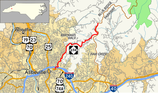
North Carolina Highway 694 is a primary state highway in the U.S. state of North Carolina. This scenic highway serves as connector between Asheville and the Blue Ridge Parkway (BRP).

South Carolina Highway 216 (SC 216) is a primary 1.22-mile (1.96 km) state highway in the state of South Carolina. The highway runs north–south, from the Kings Mountain National Military Park to North Carolina Highway 216 (NC 216) at the North Carolina state line.
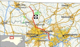
North Carolina Highway 66 (NC 66) is a 47.4-mile (76.3 km) North Carolina state highway that travels from Horneytown to Johnstown, connecting the towns and communities of eastern Forsyth and Stokes counties.

North Carolina Highway 901 (NC 901) is a primary state highway in the U.S. state of North Carolina. The highway serves to connect the town of Harmony with nearby major highways.