North Carolina Highway 275

Last updated

NC 275.svg

North Carolina Highway 275
NC 275 map.svg
Route information
Maintained by NCDOT
Length 10.7 mi [1] (17.2 km)
Existed 1930 – present
Major junctions
West endNC 274.svg NC 274 near Bessemer City
 US 321.svg US 321 in Dallas
East endNC 27.svg NC 27 in Stanley
Location
Counties Gaston
Highway system
NC 274.svg NC 274 US 276 US 276.svg

North Carolina Highway 275 (NC 275) is a primary state highway in the U.S. state of North Carolina. It connects the cities of Bessemer City, Dallas, and Stanley.

A state highway, state road, or state route is usually a road that is either numbered or maintained by a sub-national state or province. A road numbered by a state or province falls below numbered national highways in the hierarchy. Roads maintained by a state or province include both nationally numbered highways and un-numbered state highways. Depending on the state, "state highway" may be used for one meaning and "state road" or "state route" for the other.

North Carolina State of the United States of America

North Carolina is a state in the southeastern region of the United States. It borders South Carolina and Georgia to the south, Tennessee to the west, Virginia to the north, and the Atlantic Ocean to the east. North Carolina is the 28th-most extensive and the 9th-most populous of the U.S. states. The state is divided into 100 counties. The capital is Raleigh, which along with Durham and Chapel Hill is home to the largest research park in the United States. The most populous municipality is Charlotte, which is the second-largest banking center in the United States after New York City.

Bessemer City, North Carolina City in North Carolina, United States

Bessemer City is a small suburban city in Gaston County, North Carolina, United States. The population was 5,340 at the 2010 census. The city is approximately 6 miles (10 km) northwest of Gastonia and 25 miles (40 km) west of Charlotte. It was settled in 1756 and founded in 1893.

Contents

Route description

East NC 275 in Gastonia East NC 275 Gastonia.jpg
East NC 275 in Gastonia

History

The highway was established in 1930 as a new primary routing from U.S. Route 74 (US 74) and NC 20 (now NC 274) near Bessemer City to NC 27 in Stanley. The route has changed little since. [2]

U.S. Route 74 (US 74) is an east–west United States highway that runs for 515 miles (829 km) from Chattanooga, Tennessee to Wrightsville Beach, North Carolina. Predominantly in North Carolina, it serves as an important highway from the mountains to the sea, connecting the cities of Asheville, Charlotte and Wilmington.

North Carolina Highway 20 highway in North Carolina

North Carolina Highway 20 is a 27-mile (43 km) North Carolina state highway that runs through Hoke, Robeson and Bladen counties. It serves as a major road in each of the three incorporated communities through which it passes. The route is co-designated as St. Pauls Road in Raeford, Main Street in Lumber Bridge, and Broad Street in St. Pauls.

North Carolina Highway 274 highway in North Carolina

North Carolina Highway 274 (NC 274) is a primary state highway in the U.S. state of North Carolina. It connects rural areas of Lincoln and Gaston counties to Gastonia.

Junction list

The entire route is in Gaston County.

Locationmi [1] kmDestinationsNotes
Gastonia 0.00.0NC 274.svg NC 274 (Bessemer City Road) Bessemer City, Gastonia
Dallas 3.04.8NC 279.svg NC 279 north (Dallas-Cherryville Highway) Cherryville West end of NC 279 overlap
3.76.0No image.svgBusiness plate.svgNo image.svg
US 321.svg US 321 Bus. north (Dallas-High Shoals Highway) High Shoals
West end of US 321 Bus. overlap
3.86.1No image wide.svgNo image.svgBusiness plate.svgNo image.svg
US 321.svgUS 321.svg US 321 / US 321 Bus. ends Gastonia, Lincolnton, Hickory
Exit 12A–B (US 321); east end of US 321 Bus. overlap
5.08.0NC 279.svg NC 279 south (Lower Dallas Highway) Gastonia East end of NC 279 overlap
Stanley 10.717.2NC 27.svg NC 27 (Main Street) Lincolnton, Mount Holly
1.000 mi = 1.609 km; 1.000 km = 0.621 mi

Related Research Articles

North Carolina Highway 51 highway in North Carolina

North Carolina Highway 51 (NC 51) is a primary state highway in the U.S. state of North Carolina entirely in Mecklenburg County. It connects the towns of Pineville, Matthews and Mint Hill.

North Carolina Highway 7 highway in North Carolina

North Carolina Highway 7 (NC 7) is a primary state highway in the U.S. state of North Carolina. Entirely within Gaston County, it connects the towns of Lowell, McAdenville, and Belmont with the city of Gastonia.

North Carolina Highway 89 highway in North Carolina

North Carolina Highway 89 (NC 89) is a 61.3-mile-long (98.7 km) primary state highway in the U.S. state North Carolina including Mount Airy and Danbury. The entire route spans only two counties in the state: Surry and Stokes. It can be accessed from the Blue Ridge Parkway via Virginia's State Route 89 or an interchange with NC 18 which intersects NC 89 near its western terminus. Interstates 74 and 77 both intersect NC 89 west of Mount Airy.

North Carolina Highway 87 highway in North Carolina

North Carolina Highway 87 (NC 87) is a primary state highway in the U.S. state of North Carolina. NC 87 begins in the Atlantic coastal town of Southport and crosses into Virginia at the Virginia state line five miles (8 km) north of Eden in Rockingham County. At 240 miles (390 km) in length, NC 87 is the second longest state highway in the U.S. state of North Carolina. Labeled as a north–south route, NC 87 travels along a relatively straight southeast–northwest path, connecting Cape Fear region with the Piedmont and connecting the cities of Fayetteville, Sanford, and Burlington.

North Carolina Highway 207 highway in North Carolina

North Carolina Highway 207 (NC 207) is a primary state highway in the U.S. state of North Carolina. It is entirely in the boundaries of Union County and serves to connect the city of Monroe to the city of Pageland, South Carolina, at the South Carolina state line via SC 207.

North Carolina Highway 38 highway in North Carolina

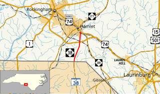
North Carolina Highway 38 (NC 38) is a primary state highway in the U.S. state of North Carolina. It runs from South Carolina state line to the town of Hamlet.

North Carolina Highway 60 highway in North Carolina

North Carolina Highway 60 (NC 60) is a primary state highway in the extreme southwestern corner of North Carolina. The highway runs north–south from the Georgia state line to U.S. Route 64/U.S. Route 74 (US 64/US 74), near Ranger.

North Carolina Highway 130 highway in North Carolina

North Carolina Highway 130 (NC 130) is a primary state highway in the U.S. state of North Carolina. The highway serves the towns and rural communities in southern Robeson County, acts as a direct route between Whiteville and Shallotte through the Green Swamp, and provides access to Holden Beach.

North Carolina Highway 242 highway in North Carolina

North Carolina Highway 242 (NC 242) is a primary state highway in the U.S. state of North Carolina. It traverses from Cerro Gordo to Benson, connecting the cities of Bladenboro, Elizabethtown, and Roseboro.

North Carolina Highway 141 highway in North Carolina

North Carolina Highway 141 (NC 141) is a primary state highway in the U.S. state of North Carolina. It serves to connect the Peachtree community, located in the Valley River Mountains, with Marble and Murphy.

Several special routes of U.S. Route 74 exist. In order from west to east they are as follows.

North Carolina Highway 72 highway in North Carolina

North Carolina Highway 72 (NC 72) is a primary state highway in the U.S. state of North Carolina that serves the communities of Red Springs and Lumberton. The east–west-signed highway physically runs more north and south through Robeson County.

North Carolina Highway 79 highway in North Carolina

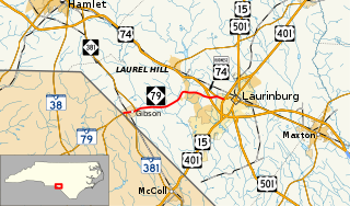
North Carolina Highway 79 (NC 79) is a primary state highway in the U.S. state of North Carolina running from the South Carolina border at Gibson to U.S. Routes US 15, US 401, and US 501 in Laurinburg.

North Carolina Highway 145 highway in North Carolina

North Carolina Highway 145 is a primary state highway in the U.S. state of North Carolina. It runs from the South Carolina state line to U.S. Route 74 entirely in Anson County.

North Carolina Highway 279 highway in North Carolina

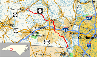
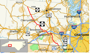
North Carolina Highway 279 (NC 279) is a primary state highway in the U.S. state of North Carolina. It connects the cities of Cherryville, Dallas, and Gastonia.

North Carolina Highway 161 highway in North Carolina

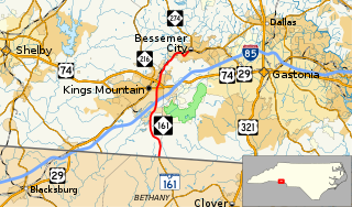
North Carolina Highway 161 (NC 161) is a primary state highway in the U.S. state of North Carolina that connects the city of Kings Mountain, North Carolina to Bessemer City, North Carolina and York, South Carolina.

North Carolina Highway 120 highway in North Carolina

North Carolina Highway 120 (NC 120) is a primary state highway in the U.S. state of North Carolina. The highway connects the community of Cliffside and the town of Mooresboro.

North Carolina Highway 381

North Carolina Highway 381 (NC 381) is a primary state highway in the U.S. state of North Carolina. The highway connects the cities of Hamlet and Gibson.

References

KML file (edithelp)
KML is from Wikidata
  1. 1 2 Google (2012-01-09). "North Carolina Highway 275" (Map). Google Maps . Google. Retrieved 2012-01-09.
  2. "NCRoads.com: N.C. 275" . Retrieved 2012-01-09.[ self-published source ]