U.S. Route 74 (US 74) is an east–west United States highway that runs for 515 miles (829 km) from Chattanooga, Tennessee to Wrightsville Beach, North Carolina. Primarily in North Carolina, it serves as an important highway from the mountains to the sea, connecting the cities of Asheville, Charlotte and Wilmington.

North Carolina Highway 740 is a primary state highway in the U.S. state of North Carolina. The main purpose of highway is to connect the town of Badin with the rest of Stanly County.

North Carolina Highway 75 (NC 75) is a primary state highway in the U.S. state of North Carolina. Its entire length runs through Union County and serves as the primary connector between the towns of Waxhaw, Mineral Springs, and Monroe. The route roughly parallels a CSX railroad line for its entire span.

North Carolina Highway 83 (NC 83) is a primary state highway in the U.S. state of North Carolina. It serves to connect the towns of Maxton and Clio, South Carolina.

North Carolina Highway 5 (NC 5) is a primary state highway in the U.S. state of North Carolina. It runs entirely in Moore County and connects the Sandhills municipalities of Aberdeen and Pinehurst. It also serves as an alternate route for NC 211. NC 5's route was designated in 1961 and it has not changed since then.

North Carolina Highway 211 (NC 211) is a 162.5-mile-long (261.5 km) primary state highway in the U.S. state of North Carolina. It traverses mostly through the Sandhills and Coastal Plain regions of the state; connecting the cities of Candor, Aberdeen, Raeford, Lumberton, Bladenboro, and Southport.

North Carolina Highway 20 is a 27-mile (43 km) North Carolina state highway that runs through Hoke, Robeson and Bladen counties. It serves as a major road in each of the three incorporated communities through which it passes. The route is co-designated as St. Pauls Road in Raeford, Main Street in Lumber Bridge, and Broad Street in St. Pauls.

North Carolina Highway 22 is a North Carolina state highway that runs in the central-north part of the state. It runs between Southern Pines and Climax. The route is signed north–south, and is 59 miles (95 km) in length.

North Carolina Highway 87 (NC 87) is a primary state highway in the U.S. state of North Carolina. NC 87 begins in the Atlantic coastal town of Southport and crosses into Virginia at the Virginia state line five miles (8 km) north of Eden in Rockingham County. At 240 miles (390 km) in length, NC 87 is the second longest state highway in the U.S. state of North Carolina with only North Carolina Highway 24 being longer. Labeled as a north–south route, NC 87 travels along a relatively straight southeast–northwest path, connecting Cape Fear region with the Piedmont. It is also the main north-south route connecting the cities of Fayetteville, Sanford, Burlington and Reidsville.

North Carolina Highway 27 (NC 27) is a primary state highway in the U.S. state of North Carolina. The route traverses 198 miles (319 km) through southern and central North Carolina, about 100 miles (160 km) of it as a concurrency with NC 24.
Interstate 95 Business is a business loop of Interstate 95 entirely within Cumberland County, North Carolina. It runs from nearby Hope Mills to Eastover, passing through the eastern side of downtown Fayetteville.

North Carolina Highway 130 (NC 130) is a primary state highway in the U.S. state of North Carolina. The highway serves the towns and rural communities in southern Robeson County, acts as a direct route between Whiteville and Shallotte through the Green Swamp, and provides access to Holden Beach.

North Carolina Highway 904 (NC 904) is a primary state highway in the U.S. state of North Carolina. The highway parallels the North Carolina-South Carolina border as it connects Fair Bluff, Tabor City, Sunset Beach, and Ocean Isle Beach.
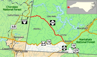
North Carolina Highway 294 (NC 294) is a primary state highway in the U.S. state of North Carolina. The highway serves to connect communities along the southern banks of the Hiwassee River.
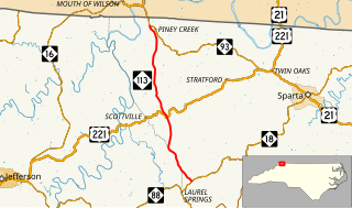
North Carolina Highway 113 is a primary state highway in the U.S. state of North Carolina. It runs from NC 18 in the community of Laurel Springs, to NC 93 in the community of Piney Creek.

North Carolina Highway 209 (NC 209) is a primary state highway in the U.S. state of North Carolina. The highway runs north–south from Lake Junaluska to Hot Springs.

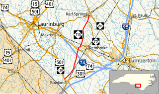
North Carolina Highway 72 (NC 72) is a primary state highway in the U.S. state of North Carolina that serves the communities of Red Springs and Lumberton. The east–west-signed highway physically runs more north and south through Robeson County.
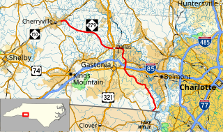
North Carolina Highway 279 (NC 279) is a primary state highway in the U.S. state of North Carolina. It connects the cities of Cherryville, Dallas, and Gastonia.
North Carolina Highway 710 (NC 710) is a primary state highway in the U.S. state of North Carolina. It connects the town of Pembroke to Interstate 74 (I-74) and U.S. Route 74 and the nearby towns of Red Springs and Rowland.

North Carolina Highway 711 (NC 711) is a primary state highway in the U.S. state of North Carolina. It connects the town of Pembroke with Interstate 95 (I-95) and U.S. Route 301 (US 301) in Lumberton. The highway travels in an east-to-west orientation but is signed as a north-south highway, entirely in Robeson County.

