Shannon, North Carolina

Last updated

Shannon, North Carolina
CDP
Shannon Post Office.jpg
A view of Shannon after a rare snowfall
USA North Carolina location map.svg
Red pog.svg
Shannon, North Carolina
Location within the state of North Carolina
Coordinates: 34°50′52″N79°08′23″W / 34.84778°N 79.13972°W / 34.84778; -79.13972
Country United States
State North Carolina
County Robeson
Area
[1]
  Total1.02 sq mi (2.65 km2)
  Land1.02 sq mi (2.65 km2)
  Water0.00 sq mi (0.00 km2)
Elevation
[2]
203 ft (62 m)
Population
 (2020)
  Total217
  Density212.33/sq mi (82.02/km2)
Time zone UTC-5 (Eastern (EST))
  Summer (DST) UTC-4 (EDT)
ZIP code
28386
Area codes 910, 472
FIPS code 37-60940 [3]
GNIS feature ID2402845 [2]

Shannon is a census-designated place (CDP) in Robeson County, North Carolina, United States. The population was 197 at the 2000 census.

Contents

Geography

According to the United States Census Bureau, the CDP has a total area of 1.0 square mile (2.6 km2), all land.

Demographics

Historical population
CensusPop.Note
2020 217
U.S. Decennial Census [4]

As of the census [3] of 2000, there were 197 people, 78 households, and 51 families residing in the CDP. The population density was 192.2 people per square mile (74.2 people/km2). There were 86 housing units at an average density of 83.9 per square mile (32.4/km2). The racial makeup of the CDP was 22.84% White, 30.46% African American, 29.95% Native American, 8.63% from other races, and 8.12% from two or more races. Hispanic or Latino of any race were 19.29% of the population.

There were 78 households, out of which 21.8% had children under the age of 18 living with them, 44.9% were married couples living together, 17.9% had a female householder with no husband present, and 34.6% were non-families. 29.5% of all households were made up of individuals, and 9.0% had someone living alone who was 65 years of age or older. The average household size was 2.53 and the average family size was 3.08.

In the CDP, the population was spread out, with 19.8% under the age of 18, 16.8% from 18 to 24, 25.4% from 25 to 44, 22.8% from 45 to 64, and 15.2% who were 65 years of age or older. The median age was 34 years. For every 100 females, there were 114.1 males. For every 100 females age 18 and over, there were 119.4 males.

The median income for a household in the CDP was $30,156, and the median income for a family was $48,194. Males had a median income of $38,333 versus $27,656 for females. The per capita income for the CDP was $13,321. About 30.9% of families and 44.1% of the population were below the poverty line, including 100.0% of those under the age of eighteen and none of those 65 or over.

Related Research Articles

<span class="mw-page-title-main">Rock Creek, Alabama</span> CDP in Alabama, United States

Rock Creek is a census-designated place in Jefferson County, Alabama, United States. Its location is northwest of Hueytown. At the 2020 census, the population was 1,471. This area was damaged by an F5 tornado on April 8, 1998. An EF2 tornado struck northwest from here on January 23, 2012.

<span class="mw-page-title-main">Meadow Lakes, Alaska</span> CDP in Alaska, United States

Meadow Lakes is a census-designated place (CDP) in Matanuska-Susitna Borough, Alaska, United States. Located west of Wasilla, it is part of the Anchorage, Alaska Metropolitan Statistical Area. As of the 2020 census, the population was 9,197, up from 7,570 in 2010. It is the fifth-most populated CDP in Alaska and the third largest community in the borough.

<span class="mw-page-title-main">Ak-Chin Village, Arizona</span> CDP in Pinal County, Arizona

Ak-Chin Village is a census-designated place (CDP) in Pinal County, Arizona, United States on the Ak-Chin (Maricopa) Reservation. The population was 862 at the 2010 census, up from 669 in 2000.

<span class="mw-page-title-main">Mountain Mesa, California</span> Census-designated place in California, United States

Mountain Mesa is a census-designated place (CDP) in Kern County, California, United States. Mountain Mesa is located 2 miles (3.2 km) west of South Lake at an elevation of 2,641 feet (805 m). The population was 777 at the 2010 census, up from 716 at the 2000 census.

<span class="mw-page-title-main">Onyx, California</span> Census-designated place in California, United States

Onyx is a census-designated place (CDP) in Kern County, California, United States. Onyx is located 3.5 miles (6 km) east-northeast of Weldon in the South Fork Valley at an elevation of 2,795 feet (852 m). The population was 475 at the 2010 census, down from 476 at the 2000 census.

Bret Harte is a census-designated place (CDP) in Stanislaus County, California, United States. The population was 5,152 at the 2010 census, down from 5,161 at the 2000 census. It is part of the Modesto Metropolitan Statistical Area. It is named for the American poet and short story writer, Bret Harte, best known for his writings about the California Gold Rush.

<span class="mw-page-title-main">Lacoochee, Florida</span> CDP in Florida, United States

Lacoochee is a census-designated place (CDP) in Pasco County, Florida, United States. The population was 1,345 at the 2000 census.

<span class="mw-page-title-main">Shannon, Georgia</span> Census-designated place & Unincorporated Community in Georgia, United States

Shannon is an unincorporated community and census-designated place (CDP) in Floyd County, Georgia, United States. It is part of the Rome, Georgia Metropolitan Statistical Area. The population was 1,862 at the 2010 census.

<span class="mw-page-title-main">Paukaa, Hawaii</span> Census-designated place in Hawaii, U.S.

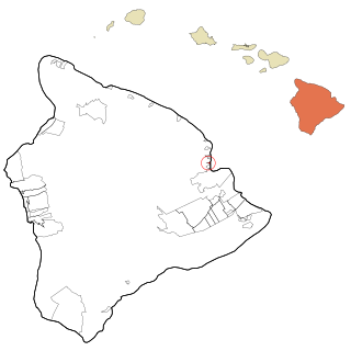
Paukaʻa is a census-designated place (CDP) in Hawaii County, Hawaii, United States. The population was 425 at the 2010 census, down from 495 at the 2000 census. The ZIP code is 96720.

<span class="mw-page-title-main">Kalaheo, Hawaii</span> Census-designated place in Hawaii, United States

Kalāheo is an unincorporated community and census-designated place (CDP) in Kauaʻi County, island of Kauaʻi, Hawaiʻi, United States. The population was 4,996 at the 2020 census, up from 3,913 at the 2000 census.

<span class="mw-page-title-main">Saugerties South, New York</span> CDP in New York, United States

Saugerties South is a hamlet in Ulster County, New York, United States. The population was 2,442 at the 2020 census.

<span class="mw-page-title-main">North Fork Village, Ohio</span> Former CDP in Ohio, United States

North Fork Village is an unincorporated community and former census-designated place (CDP) in Ross County, Ohio, United States. The population was 1,726 at the 2000 census. It was not delineated as a CDP for the 2010 census.

<span class="mw-page-title-main">Green, Oregon</span> Unincorporated community in the state of Oregon, United States

Green is a census-designated place (CDP) and unincorporated community in Douglas County, Oregon, United States. The population was 7,614 at the 2020 census.

<span class="mw-page-title-main">Pine Hollow, Oregon</span> Unincorporated community in the state of Oregon, United States

Pine Hollow is a census-designated place (CDP) and unincorporated community in Wasco County, Oregon, United States. It surrounds Pine Hollow Reservoir. The CDP population was 424 at the 2000 census.

<span class="mw-page-title-main">Valley View, Schuylkill County, Pennsylvania</span> CDP in Pennsylvania, United States

Valley View is a census-designated place (CDP) in Schuylkill County, Pennsylvania, United States. The population was 1,677 at the 2000 census.

Cane Savannah is a census-designated place (CDP) in Sumter County, South Carolina, United States. The population was 1,452 at the 2000 census. It is included in the Sumter, South Carolina Metropolitan Statistical Area.

<span class="mw-page-title-main">Green Valley, South Dakota</span> CDP in South Dakota, United States

Green Valley is a census-designated place (CDP) and unincorporated community in Pennington County, South Dakota, United States. The population was 1,051 at the 2020 census.

<span class="mw-page-title-main">West Mountain, Utah</span> CDP in Utah, United States

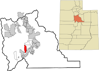
West Mountain is a census-designated place (CDP) in Utah County, Utah, United States. It is part of the Provo–Orem Metropolitan Statistical Area. As of the 2010 census, the CDP population was 1,186. The town is at the base of West Mountain and bears its name.

Milford is a census-designated place (CDP) consisting of the main area of settlement within the town of Milford in Penobscot County, Maine, United States. The population was 2,233 at the 2010 census.

Bingham is a census-designated place (CDP) in the town of Bingham in Somerset County, Maine, United States. The population was 856 at the 2000 census.

References

  1. "ArcGIS REST Services Directory". United States Census Bureau. Retrieved September 20, 2022.
  2. 1 2 U.S. Geological Survey Geographic Names Information System: Shannon, North Carolina
  3. 1 2 "U.S. Census website". United States Census Bureau . Retrieved January 31, 2008.
  4. "Census of Population and Housing". Census.gov. Retrieved June 4, 2016.