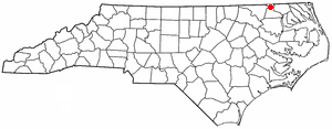
Proctorville, North Carolina

Last updated
Proctorville, North Carolina
Town Hall, Proctorville, North Carolina.jpg
Town Hall in Proctorville
USA North Carolina location map.svg
Red pog.svg
Proctorville, North Carolina
Location within the state of North Carolina
Coordinates: 34°28′31″N79°02′13″W / 34.47528°N 79.03694°W / 34.47528; -79.03694
Country United States
State North Carolina
County Robeson
Government
  MayorAllen Fowler
Area
[1]
  Total0.45 sq mi (1.18 km2)
  Land0.45 sq mi (1.18 km2)
  Water0.00 sq mi (0.00 km2)
Elevation
[2]
112 ft (34 m)
Population
 (2020)
  Total121
  Density266.52/sq mi (102.93/km2)
Time zone UTC-5 (Eastern (EST))
  Summer (DST) UTC-4 (EDT)
ZIP code
28375
Area codes 910, 472
FIPS code 37-53900 [3]
GNIS feature ID2407163 [2]

Proctorville is a town in Robeson County, North Carolina, United States. The population was 117 at the 2010 census.

Contents

History

Proctorville was settled in about 1870 and incorporated in 1913, being named for railway promotor Edward Knox Proctor Jr. [4] The W.R. Surles Memorial Library was listed on the National Register of Historic Places in 2009. [5]

Geography

According to the United States Census Bureau, the town has a total area of 0.4 square miles (1.0 km2), all land.

Demographics

Historical population
CensusPop.Note
1920 204
1930 185−9.3%
1940 20913.0%
1950 23211.0%
1960 188−19.0%
1970 157−16.5%
1980 20530.6%
1990 168−18.0%
2000 133−20.8%
2010 117−12.0%
2020 1213.4%
U.S. Decennial Census [6]

As of the census [3] of 2000, there were 133 people, 57 households, and 44 families residing in the town. The population density was 323.2 inhabitants per square mile (124.8/km2). There were 61 housing units at an average density of 148.2 per square mile (57.2/km2). The racial makeup of the town was 84.96% White, 10.53% African American and 4.51% Native American.

There were 57 households, out of which 28.1% had children under the age of 18 living with them, 59.6% were married couples living together, 15.8% had a female householder with no husband present, and 22.8% were non-families. 22.8% of all households were made up of individuals, and 10.5% had someone living alone who was 65 years of age or older. The average household size was 2.33 and the average family size was 2.70.

In the town, the population was spread out, with 19.5% under the age of 18, 6.8% from 18 to 24, 27.1% from 25 to 44, 32.3% from 45 to 64, and 14.3% who were 65 years of age or older. The median age was 43 years. For every 100 females there were 90.0 males. For every 100 females age 18 and over, there were 81.4 males.

The median income for a household in the town was $33,542, and the median income for a family was $34,167. Males had a median income of $28,438 versus $24,167 for females. The per capita income for the town was $15,206. There were 4.8% of families and 5.0% of the population living below the poverty line, including 5.0% of under eighteens and none of those over 64.

Related Research Articles

Cooper is a town in Washington County, Maine, United States. The community was named after General John Cooper, a landowner. The population was 168 at the 2020 census.

<span class="mw-page-title-main">Green Level, North Carolina</span> Town in North Carolina, United States

Green Level is a town in Alamance County, North Carolina, United States. It is part of the Burlington, North Carolina Metropolitan Statistical Area. As of the 2020 census, the population was 3,156.

<span class="mw-page-title-main">Clarkton, North Carolina</span> Town in North Carolina, United States

Clarkton is a town in Bladen County, North Carolina, United States. The population was 837 at the 2010 census.

<span class="mw-page-title-main">White Lake, North Carolina</span> Town in North Carolina, United States

White Lake is a town in Bladen County, North Carolina, United States. The population was 802 at the 2010 census, up from 529 in 2000.

Carolina Shores is a town in Brunswick County, North Carolina, United States. The population was 3,048 at the 2010 census, up from 1,482 in 2000. It is part of the Wilmington, NC Metropolitan Statistical Area.

<span class="mw-page-title-main">Glen Alpine, North Carolina</span> Town in North Carolina, United States

Glen Alpine is a town in Burke County, North Carolina, United States. The population was 1,517 at the 2010 census. It is part of the Hickory–Lenoir–Morganton Metropolitan Statistical Area.

<span class="mw-page-title-main">Gamewell, North Carolina</span> Town in North Carolina, United States

Gamewell is a town in Caldwell County, North Carolina, United States. The population was 4,051 at the 2010 census. It is part of the Hickory–Lenoir–Morganton Metropolitan Statistical Area.

<span class="mw-page-title-main">Kenansville, North Carolina</span> Town in North Carolina, United States

Kenansville is a town in Duplin County, North Carolina, United States. Its population was 855 at the 2010 census. It is the county seat of Duplin County. The town was named for James Kenan, a member of the North Carolina Senate, whose family home Liberty Hall Plantation is in Kenansville.

<span class="mw-page-title-main">Pinetops, North Carolina</span> Town in North Carolina, United States

Pinetops is a town in Edgecombe County, North Carolina, United States. It is part of the Rocky Mount, North Carolina Metropolitan Statistical Area. The population was 1,374 at the 2010 census.

<span class="mw-page-title-main">Stokesdale, North Carolina</span> Town in North Carolina, United States

Stokesdale is a town in Guilford County with a small part in Rockingham County, North Carolina, United States. The population was 5,924 at the 2020 census. Belews Lake is located nearby, and North Carolina Highway 68 and North Carolina Highway 65 both intersect U.S. Route 158 near the town's center.

<span class="mw-page-title-main">Hassell, North Carolina</span> Town in North Carolina, United States

Hassell is a town in Martin County, North Carolina, United States. The population was 84 at the 2010 census.

<span class="mw-page-title-main">Mesic, North Carolina</span> Town in North Carolina, United States

Mesic is a town in Pamlico County, North Carolina, United States. The population was 220 at the 2010 census. It is part of the New Bern, North Carolina Micropolitan Statistical Area.

<span class="mw-page-title-main">Winterville, North Carolina</span> Town in North Carolina, United States

Winterville is a town in Pitt County, North Carolina, United States. The population was 10,591 as of the 2020 Census. The town is a part of the Greenville Metropolitan Area.

<span class="mw-page-title-main">Macon, North Carolina</span> Town in North Carolina, United States

Macon is a town located in Warren County, North Carolina, United States. As of the 2010 census, the town had a total population of 119. It is named for Nathaniel Macon, long-time Speaker of the U.S. House of Representatives.

<span class="mw-page-title-main">Hanging Rock, Ohio</span> Village in Ohio, United States

Hanging Rock is a village in Lawrence County, Ohio, United States, along the Ohio River. The population was 204 at the 2020 census. It is regularly labeled a speed trap; the village earned revenues of $109,186 in mayor's court receipts in 2000, compared with $3,106 in property taxes.

<span class="mw-page-title-main">Proctorville, Ohio</span> Village in Ohio, United States

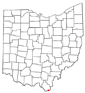
Proctorville is a village in Lawrence County, Ohio, United States, along the Ohio River. The population was 523 at the 2020 census. The East End Bridge connects Proctorville to Huntington, West Virginia across the Ohio River.
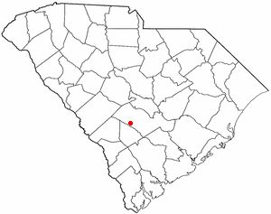
<span class="mw-page-title-main">Coburn, Pennsylvania</span> Census-designated place in Pennsylvania, United States

Coburn is a census-designated place (CDP) in Centre County, Pennsylvania, United States. It is part of the State College, Pennsylvania Metropolitan Statistical Area. The population was 236 at the 2010 census.

<span class="mw-page-title-main">Govan, South Carolina</span> Town in South Carolina, United States

Govan is a town in Bamberg County, South Carolina, United States. The population was 65 at the 2010 census.

<span class="mw-page-title-main">Lesslie, South Carolina</span> CDP in South Carolina, United States

Lesslie is a census-designated place located in York County, South Carolina, United States, southeast of the city of Rock Hill. In 2010, Lesslie had a total population of 2,882 people.

<span class="mw-page-title-main">Mitchell Heights, West Virginia</span> Town in West Virginia, United States

Mitchell Heights is a town in Logan County, West Virginia, United States. The population was 315 at the 2020 census. The town was named for an early farm on which it was established.

References

  1. "ArcGIS REST Services Directory". United States Census Bureau. Retrieved September 20, 2022.
  2. 1 2 U.S. Geological Survey Geographic Names Information System: Proctorville, North Carolina
  3. 1 2 "U.S. Census website". United States Census Bureau . Retrieved 2008-01-31.
  4. Powell, William S. (1976). The North Carolina Gazetteer: A Dictionary of Tar Heel Places. Chapel Hill: The University of North Carolina Press. p. 397. ISBN   9780807812471.
  5. "National Register Information System". National Register of Historic Places . National Park Service. July 9, 2010.
  6. "Census of Population and Housing". Census.gov. Retrieved June 4, 2015.