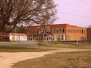
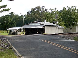
Elrod, North Carolina

Last updated

Elrod, North Carolina
CDP
USA North Carolina location map.svg
Red pog.svg
Elrod, North Carolina
Location within the state of North Carolina
Coordinates: 34°36′26″N79°13′51″W / 34.60722°N 79.23083°W / 34.60722; -79.23083
Country United States
State North Carolina
County Robeson
Area
[1]
  Total5.34 sq mi (13.83 km2)
  Land5.34 sq mi (13.83 km2)
  Water0.00 sq mi (0.00 km2)
Elevation
[2]
154 ft (47 m)
Population
 (2020)
  Total391
  Density73.25/sq mi (28.28/km2)
Time zone UTC-5 (Eastern (EST))
  Summer (DST) UTC-4 (EDT)
ZIP code
28383 [3]
Area codes 910, 472
FIPS code 37-21120 [4]
GNIS feature ID2402452 [2]

Elrod is a census-designated place (CDP) in Robeson County, North Carolina, United States. The population was 441 at the 2000 census.

Contents

Geography

According to the United States Census Bureau, the CDP has a total area of 5.3 square miles (14 km2), all land.

The first post master for Elrod, North Carolina was Malcolm H. McCall on July 29, 1892. The post office lasted until August 31, 1957. [5]

Demographics

Historical population
CensusPop.Note
2020 391
U.S. Decennial Census [6]

As of the census [4] of 2000, there were 441 people, 159 households, and 110 families residing in the CDP. The population density was 83.0 inhabitants per square mile (32.0/km2). There were 164 housing units at an average density of 30.9 per square mile (11.9/km2). The racial makeup of the CDP was 8.62% White, 23.58% African American, 65.99% Native American, and 1.81% from two or more races. Hispanic or Latino of any race were 3.85% of the population.

There were 159 households, out of which 38.4% had children under the age of 18 living with them, 44.7% were married couples living together, 18.9% had a female householder with no husband present, and 30.8% were non-families. 28.9% of all households were made up of individuals, and 12.6% had someone living alone who was 65 years of age or older. The average household size was 2.77 and the average family size was 3.45.

In the CDP, the population was spread out, with 30.2% under the age of 18, 8.8% from 18 to 24, 28.6% from 25 to 44, 21.5% from 45 to 64, and 10.9% who were 65 years of age or older. The median age was 32 years. For every 100 females, there were 81.5 males. For every 100 females age 18 and over, there were 83.3 males.

The median income for a household in the CDP was $18,125, and the median income for a family was $22,308. Males had a median income of $20,625 versus $19,125 for females. The per capita income for the CDP was $10,079. About 27.8% of families and 39.5% of the population were below the poverty line, including 57.3% of those under age 18 and 52.2% of those age 65 or over.

Related Research Articles

<span class="mw-page-title-main">Altamahaw, North Carolina</span> Census-designated place in North Carolina, United States

Altamahaw is a census-designated place (CDP) in Alamance County, North Carolina, United States. It is part of the Burlington, North Carolina Metropolitan Statistical Area. As of the 2010 census it had a population of 347. The community was listed as Altamahaw-Ossipee at the 2000 census, at which time the population was 996. The town of Ossipee incorporated in 2002 and currently has a population of 543. The remainder of the territory was reassigned as the Altamahaw CDP.

<span class="mw-page-title-main">Woodlawn, North Carolina</span> Census-designated place in North Carolina, United States

Woodlawn is a census-designated place in Alamance County, North Carolina, United States.

<span class="mw-page-title-main">Gorman, North Carolina</span> Census-designated place in North Carolina, United States

Gorman is a census-designated place (CDP) in Durham County, North Carolina, United States. The population was 1,011 at the 2010 census.

<span class="mw-page-title-main">Ashley Heights, North Carolina</span> Census-designated place in North Carolina, United States

Ashley Heights is an unincorporated community and census-designated place (CDP) in Hoke County, North Carolina, United States. The population was 380 at the 2010 census.
<span class="mw-page-title-main">Bowmore, North Carolina</span> Census-designated place in North Carolina, United States

Bowmore is an unincorporated community and census-designated place (CDP) in Hoke County, North Carolina, United States. The population was 103 at the 2010 census.

<span class="mw-page-title-main">Five Points, North Carolina</span> Census-designated place in North Carolina, United States

Five Points is a census-designated place (CDP) in Hoke County, North Carolina, United States. The population was 689 at the 2010 census.

<span class="mw-page-title-main">Silver City, North Carolina</span> Census-designated place in North Carolina, United States

Silver City is an unincorporated area and census-designated place (CDP) in Hoke County, North Carolina in the United States. The population was 882 at the 2010 census, down from 1,146 at the 2000 census.

<span class="mw-page-title-main">Lowesville, North Carolina</span> Census-designated place in North Carolina, United States

Lowesville is a census-designated place (CDP) in Lincoln County, North Carolina, United States. The population was 2,945 at the 2010 census, up from 1,440 in 2000.

<span class="mw-page-title-main">Masonboro, North Carolina</span> Former CDP in North Carolina, United States

Masonboro was a census-designated place (CDP) in New Hanover County, North Carolina. The last census count in 2000 was 11,812. Masonboro was located southeast of Wilmington near the Atlantic coast.

Barker Ten Mile is a census-designated place (CDP) in Robeson County, North Carolina, United States. The population was 952 at the 2010 census.

<span class="mw-page-title-main">Parkton, North Carolina</span> Town in North Carolina, United States

Parkton is a town in Robeson County, North Carolina, Lumberton metro area, United States. The town was so named because it was a place where farmers tied up their horses while waiting for the train. As of the 2010 census, the town population was 436.

Raemon is a census-designated place (CDP) in Robeson County, North Carolina, United States. The population was 212 at the 2000 census.

<span class="mw-page-title-main">Rex, North Carolina</span> CDP in North Carolina, United States

Rex is a census-designated place (CDP) in Robeson County, North Carolina, United States. The population was 55 at the 2010 census, and Rex ranked fourth on the list of the highest-income places in the United States.

<span class="mw-page-title-main">Shannon, North Carolina</span> CDP in North Carolina, United States

Shannon is a census-designated place (CDP) in Robeson County, North Carolina, United States. The population was 197 at the 2000 census.

Ivanhoe is a census-designated place (CDP) in Sampson County, North Carolina, United States. The population was 198 at the 2020 U.S. census.

Keener is a census-designated place (CDP) in Sampson County, North Carolina, United States. The population was 508 at the 2000 census.

Plain View is a census-designated place (CDP) in Sampson County, North Carolina, United States. The population was 1,923 at the 2020 U.S. census.

Flat Rock is a census-designated place (CDP) in Surry County, North Carolina, United States. The name "Flat Rock" stems from the community's granite quarry. The granite quarry is the largest open-face granite quarry in the world, and has been mined continuously since 1889 by the North Carolina Granite Corporation.

<span class="mw-page-title-main">Berea, South Carolina</span> CDP in South Carolina, United States

Berea is a census-designated place (CDP) in Greenville County, South Carolina, United States. The population was 14,295 at the 2010 census. It is part of the Greenville–Mauldin–Easley Metropolitan Statistical Area.

<span class="mw-page-title-main">Lesslie, South Carolina</span> CDP in South Carolina, United States

Lesslie is a census-designated place located in York County, South Carolina, United States, southeast of the city of Rock Hill. In 2010, Lesslie had a total population of 2,882 people.

References

  1. "ArcGIS REST Services Directory". United States Census Bureau. Retrieved September 20, 2022.
  2. 1 2 U.S. Geological Survey Geographic Names Information System: Elrod, North Carolina
  3. "Elrod NC ZIP Code". zipdatamaps.com. 2023. Retrieved February 17, 2023.
  4. 1 2 "U.S. Census website". United States Census Bureau . Retrieved January 31, 2008.
  5. Lewis, J.D. "Robeson County, NC Post Offices - 1787 to 1971".
  6. "Census of Population and Housing". Census.gov. Retrieved June 4, 2016.