North Carolina Highway 901

Last updated

NC 901.svg

North Carolina Highway 901
Memorial Highway
NC 901 map.svg
Route information
Maintained by NCDOT
Length 19.0 mi [1] (30.6 km)
Existed 1930 – present
Major junctions
South endUS 64.svg US 64 near Calahaln
 US 21.svg US 21 in Harmony
I-77.svg I77 near Union Grove
North endNC 115.svg NC 115 near New Hope
Location
Counties Davie, Iredell
Highway system
I-840.svg I840 NC 902 NC 902.svg

North Carolina Highway 901 (NC 901) is a primary state highway in the U.S. state of North Carolina. The highway serves to connect the town of Harmony with nearby major highways.

A state highway, state road, or state route is usually a road that is either numbered or maintained by a sub-national state or province. A road numbered by a state or province falls below numbered national highways in the hierarchy. Roads maintained by a state or province include both nationally numbered highways and un-numbered state highways. Depending on the state, "state highway" may be used for one meaning and "state road" or "state route" for the other.

North Carolina State of the United States of America

North Carolina is a state in the southeastern region of the United States. It borders South Carolina and Georgia to the south, Tennessee to the west, Virginia to the north, and the Atlantic Ocean to the east. North Carolina is the 28th-most extensive and the 9th-most populous of the U.S. states. The state is divided into 100 counties. The capital is Raleigh, which along with Durham and Chapel Hill is home to the largest research park in the United States. The most populous municipality is Charlotte, which is the second-largest banking center in the United States after New York City.

Harmony, North Carolina Town in North Carolina, United States

Harmony is a town in Iredell County, North Carolina, United States. The town is located in northeastern Iredell County and lies in the eastern portion of the North Carolina High Country. It is primarily located in Turnersburg Township, with its northernmost portion in Eagle Mills Township. The population was 531 at the 2010 census.

Contents

Route description

NC 901 is a two-lane rural highway that traverses 19.0 miles (30.6 km) from US 64, near Calahaln, to NC 115, near New Hope. Surrounded most of its journey with farmland, NC 901 is a no-thrills road through northern Iredell County.

U.S. Route 64 in North Carolina highway in North Carolina

U.S. Route 64 (US 64) is the longest numbered route in the U.S. state of North Carolina, running 604 miles (972 km) from the Tennessee state line to the Outer Banks. The route passes through the westernmost municipality in the state, Murphy, and one of the most easternmost municipalities, Manteo, making US 64 a symbolic representation of the phrase "from Murphy to Manteo" which is used to refer to the expanse of the state. The highway is a major east-west route through the central and eastern portion of the state.

North Carolina Highway 115 highway in North Carolina

North Carolina Highway 115 is a primary state highway in the U.S. state of North Carolina. It runs from U.S. Route 21 in North Charlotte north through Mecklenburg, Iredell and Wilkes counties. Its northern terminus is at its intersection with US 421 Business, NC 18 and NC 268 in North Wilkesboro.

Iredell County, North Carolina County in North Carolina, United States

Iredell County is an administrative division (county) of the U.S. state of North Carolina. According to US Census projections in 2017, the population was 169,798. Its county seat is Statesville, and its largest town is Mooresville. The county was formed in 1788, annexed from Rowan County. It is named for James Iredell, one of the first justices of the Supreme Court of the United States.

NC 901 is a viable alternate route between Mocksville and Wilkesboro; it is shorter in mileage, though takes a few minutes longer than via US 601 and US 421.

Mocksville, North Carolina Town in North Carolina, United States

Mocksville is a town in Davie County, North Carolina, United States. The population was 5,051 at the 2010 census. It is the county seat of Davie County.

Wilkesboro, North Carolina Town in North Carolina, Wilkes

Wilkesboro is a town in and the county seat of Wilkes County, North Carolina. The population was 3,413 at the 2010 census. The town is located along the south bank of the Yadkin River, directly opposite the town of North Wilkesboro. Wilkesboro is a Small Town Main Street community and has recently revitalized its historic downtown to include the Carolina West Wireless Community Commons, Wilkes Communications Pavilion, Heritage Square and Splash Pad. Cub Creek Park is adjacent to the downtown and contains many amenities to include baseball, walking trails, mountain biking trails, trout fishing, dog park, basketball, tennis, and pickleball courts, picnic shelters, etc. Wilkesboro is also the home of the annual MerleFest and Carolina in the Fall festivals.

U.S. Route 601 (US 601) is a north–south United States highway that runs for 316.3 miles (509.0 km) from U.S. Route 321, near Tarboro, South Carolina, to U.S. Route 52, in Mount Airy, North Carolina.

History

Established by 1930 as a new primary routing, from US 64/NC 90 to US 21/NC 26, in Harmony. In 1937, NC 901 was extended northwest to its current northern terminus at NC 115.

North Carolina Highway 90 highway in North Carolina

North Carolina Highway 90 is a primary state highway in the U.S. state of North Carolina. It is one of the few highways in the state with an unpaved portion.

Junction list

CountyLocationmi [1] kmDestinationsNotes
Davie 0.00.0US 64.svg US 64  Mocksville, Statesville
Iredell Harmony 6.410.3US 21.svg US 21 (Harmony Highway) Jonesville, Statesville
11.618.7I-77.svg I77  Elkin, Statesville
19.030.6NC 115.svg NC 115 (Wilkesboro Highway) Wilkesboro, Statesville
1.000 mi = 1.609 km; 1.000 km = 0.621 mi

Related Research Articles

North Carolina Highway 159 highway in North Carolina

North Carolina Highway 159 is a primary state highway in the U.S. state of North Carolina. It serves as access to the North Carolina Zoological Park.

North Carolina Highway 345 highway in North Carolina

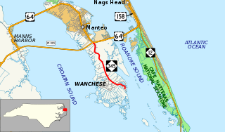
North Carolina Highway 345 (NC 345) is a primary state highway in the U.S. state of North Carolina connecting Wanchese and Manteo on Roanoke Island. The highway begins at The Lane and Thicket Lump Drive south of the town marina. Following Mill Landing Road through Wanchese, the road eventually becomes the western boundary for the Roanoke Island Marshes Dedicated Nature Preserve, before reaching its northern terminus at US 64.

North Carolina Highway 49 highway in North Carolina

North Carolina Highway 49 (NC 49) is a primary state highway in the U.S. state of North Carolina. It traverses much of the Piedmont region of North Carolina.

North Carolina Highway 18 highway in North Carolina

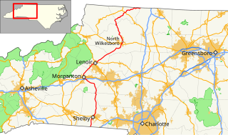
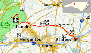
North Carolina Highway 18 (NC 18) is a primary state highway in the U.S. state of North Carolina. Traveling north–south through the Foothills region, it connects the cities of Shelby, Morganton, Lenoir, Wilkesboro and North Wilkesboro.

North Carolina Highway 87 highway in North Carolina

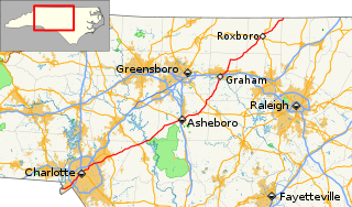
North Carolina Highway 87 (NC 87) is a primary state highway in the U.S. state of North Carolina. NC 87 begins in the Atlantic coastal town of Southport and crosses into Virginia at the Virginia state line five miles (8 km) north of Eden in Rockingham County. At 240 miles (390 km) in length, NC 87 is the second longest state highway in the U.S. state of North Carolina. Labeled as a north–south route, NC 87 travels along a relatively straight southeast–northwest path, connecting Cape Fear region with the Piedmont and connecting the cities of Fayetteville, Sanford, and Burlington.

North Carolina Highway 28 highway in North Carolina

North Carolina Highway 28 (NC 28) is an 81.2-mile-long (130.7 km) primary state highway in the U.S. state of North Carolina. The highway runs north–south through the Nantahala National Forest in Western North Carolina.

North Carolina Highway 268 highway in North Carolina

North Carolina Highway 268 (NC 268) is a primary state highway in the U.S. state of North Carolina. It connects many communities as it traverses through the northwestern North Carolina mountains and foothills.

North Carolina Highway 903 highway in North Carolina

North Carolina Highway 903 (NC 903) is a primary state highway in the U.S. state of North Carolina. It serves as predominantly rural highway in the Inner Banks region and arterial road in and around Greenville. The road covers a total of 200 miles (320 km), in a zigzag pattern through the state.

North Carolina Highway 94 highway in North Carolina

North Carolina Highway 94 (NC 94) is a primary state highway in the U.S. state of North Carolina. It runs from Hyde County in Swan Quarter to Chowan County near Edenton.

North Carolina Highway 242 highway in North Carolina

North Carolina Highway 242 (NC 242) is a primary state highway in the U.S. state of North Carolina. It traverses from Cerro Gordo to Benson, connecting the cities of Bladenboro, Elizabethtown, and Roseboro.

North Carolina Highway 141 highway in North Carolina

North Carolina Highway 141 (NC 141) is a primary state highway in the U.S. state of North Carolina. It serves to connect the Peachtree community, located in the Valley River Mountains, with Marble and Murphy.

North Carolina Highway 581 highway in North Carolina

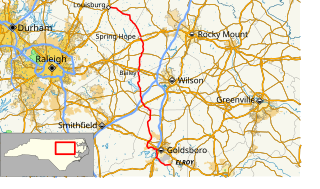
North Carolina Highway 581 (NC 581) is a primary state highway in the U.S. state of North Carolina. The highway travels from Goldsboro to Louisburg, connecting various rural communities in between.

North Carolina Highway 45 highway in North Carolina

North Carolina Highway 45 (NC 45) is a primary state highway in the U.S. state of North Carolina. The highway traverses north-south, from Ocracoke to Winton.

North Carolina Highway 61 highway in North Carolina

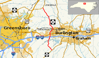
North Carolina Highway 61 (NC 61) is a primary state highway in the U.S. state of North Carolina. It serves as the main north–south highway in eastern Guilford County, connecting Whitsett and Gibsonville.

North Carolina Highway 902 highway in North Carolina

North Carolina Highway 902 (NC 902) is a primary state highway in the U.S. state of North Carolina. The highway connects southwest Chatham County with the county seat of Pittsboro. NC 902 has mostly rural routing going northeast most of the way. NC 902 was created in 1929 running from U.S. Route 64 (US 64) near Asheboro to Carthage but has since been truncated to its current routing over a long period of time.

North Carolina Highway 231

North Carolina Highway 231 (NC 231) is a 25.4-mile-long (40.9 km) primary state highway in the U.S. state of North Carolina. The highway serves to connect communities in northern Johnston and western Nash counties.

North Carolina Highway 704

North Carolina Highway 704 (NC 704) is a primary state highway in the U.S. state of North Carolina. The highway connects Madison with northern Stokes County and the Wentworth-Reidsville area.

North Carolina Highway 152

North Carolina Highway 152 (NC 152) is a 25.5-mile-long (41.0 km) primary state highway in the U.S. state of North Carolina. It serves as the main thoroughfare in southern Rowan County.

References

  1. 1 2 Google (November 18, 2013). "North Carolina Highway 901" (Map). Google Maps . Google. Retrieved November 18, 2013.
KML file (edithelp)
KML is from Wikidata