This article relies largely or entirely on a single source .(January 2016) |
North Channel Bridge | |
|---|---|
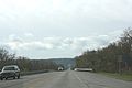
 North Channel Bridge, looking south from the north approach. | |
| Coordinates | 44°03′44″N91°38′15″W / 44.06222°N 91.63750°W |
| Carries | Two lanes of |
| Crosses | Mississippi River |
| Locale | Winona, Minnesota |
| Maintained by | Wisconsin Department of Transportation |
| ID number | B-06-0752 (Wisconsin), 5930 (Minnesota) |
| Characteristics | |
| Design | Concrete girder bridge |
| Total length | 1,008 feet (307 m) |
| Width | 61 feet (19 m) |
| Longest span | 101 feet (31 m) |
| Clearance below | 20 feet (6.1 m) |
| History | |
| Opened | 1997 |
| Location | |
 | |
The North Channel Bridge crosses the north channel of the Mississippi River between Latsch Island (part of Winona, Minnesota) and Buffalo County, Wisconsin.
Contents
The bridge has a street setup, with one lane in either direction. It carries Minnesota State Highway 43 and WI 54 in either direction. Immediately to the south is the Main Channel Bridge.