
The Mohawk River is a 149-mile-long (240 km) river in the U.S. state of New York. It is the largest tributary of the Hudson River. The Mohawk flows into the Hudson in Cohoes, New York, a few miles north of the city of Albany. The river is named for the Mohawk Nation of the Iroquois Confederacy. It is a major waterway in north-central New York. The largest tributary, the Schoharie Creek, accounts for over one quarter (26.83%) of the Mohawk River's watershed. Another main tributary is the West Canada Creek, which makes up for 16.33% of the Mohawk's watershed.

The Unadilla River is a 71-mile-long (114 km) river in the Central New York Region of New York State. The river begins northeast of the hamlet of Millers Mills and flows generally south to the village of Sidney, where it converges with the Susquehanna River, which drains into the Chesapeake Bay, a bay of the Atlantic Ocean.

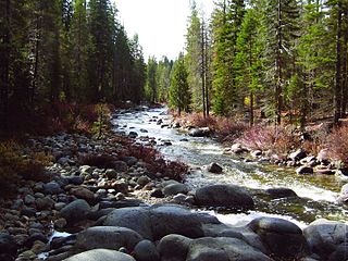
The Clavey River is a tributary of the Tuolumne River in the Sierra Nevada, located in the Stanislaus National Forest and Tuolumne County, California. The river is 31.3 miles (50.4 km) long, and is one of the few undammed rivers on the western slope of the Sierra. Via the Tuolumne River, the Clavey is part of the San Joaquin River watershed.

The Chippewa River is a stream in Michigan, United States, that runs 91.8 miles (147.7 km) through the central Lower Peninsula. The Chippewa is a tributary of the Tittabawassee River and is thus part of the Saginaw River drainage basin. The river is named after the Chippewa people.
Carp River is a 40.2-mile-long (64.7 km) river in Chippewa and Mackinac counties in the U.S. state of Michigan. 21.7 miles (34.9 km) of the river were added to the National Wild and Scenic Rivers System in 1992.
The Black River is a 41.1-mile-long (66.1 km) river on the Upper Peninsula of the U.S. state of Michigan, flowing mostly in Gogebic County into Lake Superior at 46°40′03″N90°02′57″W. Its source at 46°18′54″N90°01′15″W is a boreal wetland on the border with Iron County, Wisconsin. The northern section of the river, 14 miles (23 km) within the boundaries of the Ottawa National Forest, was designated a National Wild and Scenic River in 1992.
Black River is a 4.2-mile-long (6.8 km) river in the southwest part of the U.S. state of Michigan that empties into Lake Michigan in South Haven at 42°24′08″N86°17′04″W, where it discharges past the South Pier Lighthouse. The river takes its name from the dark brown color of its water, which is caused by suspended sediments and organic materials picked up along its course. The river supports a variety of wildlife including trout, snapping turtles, leeches, and many other varieties of flora and fauna. The Black River watershed encompasses 287 square miles (740 km2) across two counties and 13 townships.

Wappinger Creek is a 41.7-mile-long (67.1 km) creek which runs from Thompson Pond to the Hudson River at New Hamburg in Dutchess County, New York, United States. It is the longest creek in Dutchess County, with the largest watershed in the county.
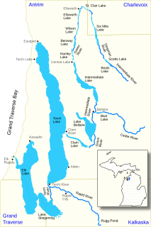
The Elk River Chain of Lakes Watershed is a 75-mile-long (121 km) waterway consisting of 14 lakes and connecting rivers in the northwestern section of the Lower Peninsula of the U.S. state of Michigan, which empty into Lake Michigan.

Otego Creek is a 32.7-mile-long (52.6 km) tributary of the Susquehanna River in Otsego County, New York. Otego Creek rises in the Town of Otsego and flows south through the Towns of Hartwick and Laurens, before joining the Susquehanna River southwest of the City of Oneonta.

The Pine River is a 103-mile-long (166 km) river in the Lower Peninsula of the U.S. state of Michigan. The Pine River is a tributary of the Chippewa River and is thus part of the Saginaw River drainage basin.

The Middle Fork Kings River is a 37.2-mile (59.9 km) tributary of the Kings River in Kings Canyon National Park, California, in the southern Sierra Nevada. Draining 318 square miles (820 km2) – almost all of it wilderness – the Middle Fork is one of the largest wholly undeveloped watersheds in the state, with no dams or paved roads within its basin. The entire length of the Middle Fork is designated a National Wild and Scenic River.

Snake Mountain is a mountain located along the border between North Carolina and Tennessee, east of the community of Zionville, in the southeastern United States. It is part of the Blue Ridge Mountains, and includes parts of Watauga County, North Carolina, and Johnson County, Tennessee. It has two peaks, the highest of which reaches an elevation of 5,564 feet (1,696 m). The lower peak, at 5,518 feet (1,682 m), is Johnson County's high point.

Pacheco Creek is a 28 miles (45 km) west by southwest flowing stream which heads in the Diablo Range in southeastern Santa Clara County and flows to San Felipe Lake, the beginning of the Pajaro River mainstem, in San Benito County, California.

The Canajoharie Creek is a river that flows into the Mohawk River in the Village of Canajoharie in the U.S. State of New York. The name "Canajoharie" is a Mohawk language term meaning "the pot that washes itself", referring to the "Canajoharie Boiling Pot", a 20-foot (6.1 m) wide and 10-foot (3.0 m) deep pothole in the Canajoharie Creek, just south of the village of Canajoharie. Bowmans Creek is one main tributary that enters the creek east of the Hamlet of Sprout Brook. The other main tributary is Brimstone Creek which enters the creek north-northwest of the Village of Ames.
South Chuctanunda Creek is a river in Montgomery and Schenectady counties in the state of New York. It flows into the Mohawk River in Amsterdam.

Tapeats Creek is a creek located entirely within the Grand Canyon National Park. It flows southwest from its source near the North Rim of the canyon to the Colorado River at the base of the canyon. It was named by the Second Powell Expedition in the winter of 1871–1872 for a Southern Paiute Indian who claimed ownership of the stream. It contributes the largest amount of water to the Colorado of any tributary on the north side within the Grand Canyon.
Dinkey Creek is a large stream in the southern Sierra Nevada, in Fresno County, California. The creek is 29.2 miles (47.0 km) long, flowing undammed in a southerly direction through the Sierra National Forest. It is a tributary of the North Fork Kings River, in turn part of the Kings River system which drains into the de-watered Tulare Lake bed.

