Related Research Articles
Wuthara Island is a national park in Queensland, Australia. It is located 1,962 km northwest of Brisbane in the Great Barrier Reef Marine Park Queensland, about 40 km North East of Kutini-Payamu National Park and Lockhart River in the Cape Weymouth area in the Coral Sea just off the small locality of Portland Road.

Hope Islands National Park is a national park in Queensland (Australia) 1,521 km north-west of Brisbane. The park consists of four islands: East Hope and West Hope, Snapper Island and Struck Island.

Lizard Island is an island on the Great Barrier Reef in Queensland (Australia), 1,624-kilometre (1,009 mi) northwest of Brisbane and part of the Lizard Island Group that also includes Palfrey Island. It is part of the Lizard Island National Park. Lizard Island is within the locality of Lizard in the Cook Shire.

Orpheus Island National Park is a national park on Orpheus Island, in North Queensland, Australia. The Aboriginal name for this island is Goolboddi Island. It is one of the Palm Islands group, 1,189 km (739 mi) northwest of Brisbane, as is Pelorus Island 800 metres (2,600 ft) to the north; both are in the Shire of Hinchinbrook. Besides Orpheus Island, the national park also includes Albino Rock, which is located 2.6 kilometres (1.6 mi) east of Great Palm Island. Orpheus Island is a continental island.

Far North Queensland (FNQ) is the northernmost part of the Australian state of Queensland. Its largest city is Cairns and it is dominated geographically by Cape York Peninsula, which stretches north to the Torres Strait, and west to the Gulf Country. The waters of Torres Strait include the only international border in the area contiguous with the Australian mainland, between Australia and Papua New Guinea.
South Direction Island is an island in the offshore locality of Lizard in the Shire of Cook, Queensland, Australia. It is 25 km north-east of Cape Flattery in the Great Barrier Reef Marine Park Authority and about 25 km south of Lizard Island, Queensland, Australia.
Palfrey Island is an island in the offshore locality of Lizard in the Shire of Cook, Queensland, Australia. It is 270 km north of Cairns and is part of the Lizard Island Group and south of Lizard Island,There is an automated lighthouse structure situated on this island.
Eagle Island is an island in the locality of Lizard in the Shire of Cook, Queensland, Australia. It is in the Lizard Island National Park, approximately 2,000 km north-west of Brisbane. The island is south-west of Lizard Island situated 270 km north of Cairns, Queensland.
North and South Barrow Islands are a pair of islands within the Great Barrier Reef Marine Park in Ninian Bay, 90 km South East of Cape Melville, Queensland, Australia. The islands take their names from Barrow Point, a few hundred metres away, where a mine is located. Barrow Point in turn was named in May 1815 by Lieutenant Charles Jeffreys of the HM Colonial brig Kangaroo, probably after John Barrow, the Secretary to the Admiralty.
Sherrard Island is an island in the Aboriginal Shire of Lockhart River in Queensland, Australia.
Bootie Island is a small island in the Shire of Cook in Far North Queensland, Australia. It is part of the Cockburn Islands Group.

Keppel Bay is a bay in Central Queensland, Australia at the mouth of the Fitzroy River on the coast of the Coral Sea.

The Shire of Cook is a local government area in Far North Queensland, Australia. The Shire covers most of the eastern and central parts of Cape York Peninsula, the most northerly section of the Australian mainland.
The Shire of Torres is a local government area located in Far North Queensland, Australia, covering large sections of the Torres Strait Islands and the northern tip of Cape York Peninsula north of 11°S latitude. It holds two distinctions—it is the northernmost Local Government Area in Australia, and is the only one to abut an international border – it is at one point just 73 kilometres (45 mi) from Papua New Guinea. It is administered from Thursday Island.

Endeavour Reef is a coral reef within the Great Barrier Reef. It is within the Shire of Cook, Queensland, Australia. The reef is about 7 kilometres (4.3 mi) long and runs in an east–west direction. The center of the reef is located at 15°46′40″S145°34′53″E. It is about 6 kilometres (3.7 mi) south-east of the Hope Islands in the Hope Islands National Park and 12 kilometres (7.5 mi) off the mainland.
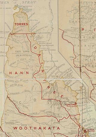
The Shire of Hann is a former local government area in Far North Queensland, Australia.

The Mossman River is a river in lower Cape York Peninsula, Queensland, Australia.
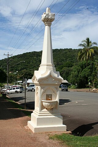
Mary Watson's Monument is a heritage-listed memorial at Charlotte Street, Cooktown, Shire of Cook, Queensland, Australia. It was designed and built by Ernest Greenway in 1886. It was added to the Queensland Heritage Register on 21 October 1992.
The Aboriginal Shire of Lockhart River is a local government area in Far North Queensland, Australia.
Lizard is an offshore locality consisting of a number of islands in the Great Barrier Reef area of the Coral Sea within the Shire of Cook, Queensland, Australia. It includes Lizard Island. In the 2021 census, Lizard had a population of 65 people.
References
- ↑ "North Direction Island – island in the Shire of Cook (entry 24631)". Queensland Place Names. Queensland Government . Retrieved 28 October 2023.
- ↑ "Map of North Direction Island, QLD".
| | This Queensland location article is a stub. You can help Wikipedia by expanding it. |