Lizard, Queensland

Last updated

Map all coordinates using: OpenStreetMap
Lizard
Queensland
Lizard-Island-Australia-2018-Luka-Peternel.jpg
Lizard Island beach with Prince Charles Island (right), 2018
Australia Queensland location map.svg
Red pog.svg
Lizard
Coordinates 14°45′16″S145°20′24″E / 14.7544°S 145.34°E / -14.7544; 145.34 (Lizard (centre of locality))
Population65 (SAL 2021) [1]
Postcode(s) 4871
Area2,833.7 km2 (1,094.1 sq mi)
Time zone AEST (UTC+10:00)
LGA(s) Shire of Cook
State electorate(s) Cook
Federal division(s) Leichhardt
Suburbs around Lizard:
Starcke Coral Sea Coral Sea
Starcke Lizard Coral Sea
Hope Vale Hope Vale Coral Sea

Lizard is an offshore locality consisting of a number of islands in the Great Barrier Reef area of the Coral Sea within the Shire of Cook, Queensland, Australia. It includes Lizard Island. In the 2021 census, Lizard had a population of 65 people. [2]

Contents

Geography

The locality consists of many island groups and islands. Being in the Great Barrier Reef area, there are many coral reefs with low-lying islands (known as coral cays) which can develop or erode over time. Consequently many are unnamed or poorly documented. The named features are listed in the table, from north to south.

NameSizeCoordinatesNotes
Nymph Island76.3396 hectares (188.639 acres) 14°39′15″S145°15′10″E / 14.6543°S 145.2529°E / -14.6543; 145.2529 (Nymph Island) It is surrounded by the Nymph Reef. It is part of the Turtle Group National Park. [3] [4] [5]
Prince Charles Island1.0756 hectares (2.658 acres) 14°40′00″S145°26′38″E / 14.6666°S 145.4439°E / -14.6666; 145.4439 (Prince Charles Island (Osprey Island)) Also known as Osprey Island, it is just off the west coast of Lizard Island connected by the Lizard Island Reef. It is part of the Lizard Island National Park. [3] [5]
Lizard Island 8.6287 square kilometres (3.3316 sq mi) 14°40′02″S145°27′38″E / 14.6671°S 145.4606°E / -14.6671; 145.4606 (Lizard Island) Named on 12 August 1770 by Lieutenant James Cook, commander of HMS Endeavour, noting "...the only land animals we saw here were lizards". [6] [3] It is a continental island rising to 350 metres (1,150 ft) above sea level with the Lizard Island Reef. It is the largest island in the Lizard Island National Park. [5]
Seabird Isletapprox 1.75 hectares (4.3 acres) 14°41′30″S145°27′57″E / 14.6916°S 145.4658°E / -14.6916; 145.4658 (Seabird Islet) A small continental island, covered in grass, shrubs and granite boulders. It is a nesting site for osprey, black-naped terns, bridled terns, silver gulls, Torres Strait Pigeons and reef herons. [7] It is south of Lizard Head on Lizard Island and is part of the Lizard Island Reef and the Lizard Island National Park. [5] It is the only named island in the Bird Islets.
Bird Islets 14°41′32″S145°27′59″E / 14.6922°S 145.4663°E / -14.6922; 145.4663 (Bird Islets) An island group south of Lizard Head on Lizard Island within the Lizard Island Reef. Its only named island is Seabird Islet. [8]
Palfrey Island 51.8023 hectares (128.006 acres) 14°41′33″S145°26′47″E / 14.6926°S 145.4464°E / -14.6926; 145.4464 (Palfrey Island) A continental island rising to 130 metres (430 ft) to south of Research Point on Lizard Island and part of the Lizard Island Reef and the Lizard Island National Park. [3] [9] [5]
Eagle Island 3.5178 hectares (8.693 acres) 14°41′48″S145°22′39″E / 14.6968°S 145.3774°E / -14.6968; 145.3774 (Eagle Island) Within the Eyrie Reef, it was named by Lieutenant James Cook on the HMS Endeavour on 13 August 1770. It is part of the Lizard Island National Park. [3] [10] [5]
South Island28.6527 hectares (70.802 acres) 14°42′06″S145°27′16″E / 14.7018°S 145.4544°E / -14.7018; 145.4544 (South Island (Newt Island)) Also known as Newt Island, it is a continental island rising to 110 metres (360 ft) south of Lizard Island. It is part of the Lizard Island Reef and the Island Island National Park. [3] [11] [5]
Turtle Group 14°43′22″S145°11′38″E / 14.7227°S 145.1938°E / -14.7227; 145.1938 (Turtle Group) An island group consisting of a number of unnamed islands within the Turtle Group Reef. It is part of the Turtle Group National Park. [12] [5]
Pethebridge Islets 14°44′02″S145°05′30″E / 14.7338°S 145.0916°E / -14.7338; 145.0916 (Pethebridge Islets) An island group consisting of two unnamed islands within the Pethebridge Islets Reef, formerly known as Q Reef or Kew Reef. It is part of the Turtle Group National Park. [13] [5]
North Direction Island 48.1906 hectares (119.082 acres) 14°44′44″S145°30′41″E / 14.7455°S 145.5115°E / -14.7455; 145.5115 (North Direction Island (Northern Direction Island)) Also known as Northern Direction Island, it is surrounded by the North Direction Reef. [3] [14] [5]
South Direction Island 55.2957 hectares (136.639 acres) 14°49′43″S145°31′30″E / 14.8285°S 145.5249°E / -14.8285; 145.5249 (South Direction Island) It is surrounded by the South Direction Reef. [3] [15] [5]
Rocky Islets 14°51′45″S145°28′38″E / 14.8625°S 145.4772°E / -14.8625; 145.4772 (Rocky Islets) An island group of 3 unnamed islands joined by the Rocky Islets Reef. One of them rises to 30 metres (98 ft). The group is within the Three Islands Group National Park. [16]

There are three national parks within the locality:

History

The locality takes its name from Lizard Island, the largest island in the locality. The island was named on 12 August 1770 by Lieutenant James Cook, commander of HMS Endeavour, with the comment "...the only land animals we saw here were lizards". [20]

Heritage listings

Mrs Watson's Cottage on Lizard Island is listed on the Queensland Heritage Register. [21]

Demographics

In the 2016 census, Lizard had a population of 49 people. [22]

In the 2021 census, Lizard had a population of 65 people. [2]

Education

Lizard Island Airport, 2015 Lizard Island Airport.jpg
Lizard Island Airport, 2015

There are no schools in Lizard nor nearby. The options are distance education and boarding school. [23]

Transport

Lizard Island Airport is on Lizard Island ( 14°40′16″S145°27′09″E / 14.6712°S 145.4525°E / -14.6712; 145.4525 (Lizard Island Airfield) ). [24]

Related Research Articles

Wuthara Island is a national park in Queensland, Australia. It is located 1,962 km northwest of Brisbane in the Great Barrier Reef Marine Park Queensland, about 40 km North East of Kutini-Payamu National Park and Lockhart River in the Cape Weymouth area in the Coral Sea just off the small locality of Portland Road.

<span class="mw-page-title-main">Lizard Island</span> Protected area in Queensland, Australia

Lizard Island is an island on the Great Barrier Reef in Queensland (Australia), 1,624-kilometre (1,009 mi) northwest of Brisbane and part of the Lizard Island Group that also includes Palfrey Island. It is part of the Lizard Island National Park. Lizard Island is within the locality of Lizard in the Cook Shire.

<span class="mw-page-title-main">Palm Island, Queensland</span> Locality consisting of a group of islands in Queensland, Australia

Palm Island is a locality consisting of an island group of 16 islands, split between the Shire of Hinchinbrook and the Aboriginal Shire of Palm Island, in Queensland, Australia. The locality coincides with the geographical entity known as the Palm Island group, also known as the Greater Palm group, originally named the Palm Isles.

<span class="mw-page-title-main">Lakeland, Queensland</span> Town in Queensland, Australia

Lakeland is a rural town and locality in the Shire of Cook, Queensland, Australia. In the 2016 census, the locality of Lakeland had a population of 299 people.

<span class="mw-page-title-main">Whitsunday Islands</span> Island group in Queensland, Australia

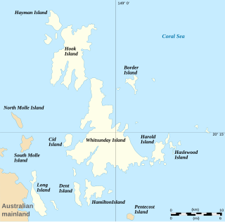
The Whitsunday Islands are 74 continental islands of various sizes off the central coast of Queensland, Australia, 900 kilometres north of Brisbane. The northernmost of the islands are off the coast by the town of Bowen, while the southernmost islands are off the coast by Proserpine. The island group is centred on Whitsunday Island, while the commercial centre is Hamilton Island. The traditional owners of the area are the Ngaro people and the Gia people, whose Juru people has the only legally recognised native title in the Whitsunday Region.

<span class="mw-page-title-main">Seventeen Seventy, Queensland</span> Town in Queensland, Australia

Seventeen Seventy, sometimes inaccurately written as 1770 or Town of 1770, is a coastal town and locality in the Gladstone Region, Queensland, Australia. In the 2016 census, the locality of Seventeen Seventy had a population of 69 people.

<span class="mw-page-title-main">Green Island (Queensland)</span> Place in Queensland, Australia

Green Island is a marine island and locality in the Cairns Region, Queensland, Australia. In the 2021 census, Green Island had a population of 20 people.

South Direction Island is an island in the offshore locality of Lizard in the Shire of Cook, Queensland, Australia. It is 25 km north-east of Cape Flattery in the Great Barrier Reef Marine Park Authority and about 25 km south of Lizard Island, Queensland, Australia.

North Direction Island is an island in the offshore locality of Lizard in the Shire of Cook, Queensland, Australia.

Palfrey Island is an island in the offshore locality of Lizard in the Shire of Cook, Queensland, Australia. It is 270 km north of Cairns and is part of the Lizard Island Group and south of Lizard Island,There is an automated lighthouse structure situated on this island.

Eagle Island is an island in the locality of Lizard in the Shire of Cook, Queensland, Australia. It is in the Lizard Island National Park, approximately 2,000 km north-west of Brisbane. The island is south-west of Lizard Island situated 270 km north of Cairns, Queensland.

Rossville is a town and coastal locality in the Shire of Cook, Queensland, Australia. In the 2016 census, the locality of Rossville had a population of 204 people.

Forrest Beach is a small coastal locality in the Shire of Hinchinbrook, Queensland, Australia. In the 2016 census, Forrest Beach had a population of 1,254 people.

<span class="mw-page-title-main">Welsby, Queensland</span> Suburb of Bribie Island, Queensland, Australia

Welsby is a coastal locality on Bribie Island in the City of Moreton Bay, Queensland, Australia. In the 2016 census Welsby had a population of 5 people.

<span class="mw-page-title-main">Bloomfield, Queensland</span> Suburb of Shire of Cook, Queensland, Australia

Bloomfield is a town in the Shire of Cook and a coastal locality which is split between the Shire of Cook and the Shire of Douglas in Queensland, Australia. The neighbourhood of Ayton is within the locality. In the 2016 census, Bloomfield had a population of 204 people.

Yarraden is a coastal rural locality in the Shire of Cook, Queensland, Australia. In the 2016 census Yarraden had a population of 11 people.

<span class="mw-page-title-main">Coral Cove, Queensland</span> Suburb of Bundaberg, Queensland, Australia

Coral Cove is a coastal locality in the Bundaberg Region, Queensland, Australia. In the 2016 census, Coral Cove had a population of 1,268 people. It has been used as a diving point by tourists and contains the Coral Cove Golf course.

<span class="mw-page-title-main">Iron Range, Queensland</span> Suburb of Shire of Cook, Queensland, Australia

Iron Range is a coastal locality in the Shire of Cook, Queensland, Australia. The town of Portland Road is on a north-east headland in the locality. In the 2021 census, Iron Range had a population of 30 people.

Stanage is a coastal rural town and locality in the Livingstone Shire, Queensland, Australia. In the 2016 census, Stanage had a population of 83 people.

Low Isles is a locality in the Shire of Douglas, Queensland, Australia. In the 2016 census, Low Isles had a population of 0 people.

References

  1. Australian Bureau of Statistics (28 June 2022). "Lizard (Suburb and Locality)". Australian Census 2021 QuickStats. Retrieved 28 June 2022.  OOjs UI icon edit-ltr-progressive.svg
  2. 1 2 Australian Bureau of Statistics (28 June 2022). "Lizard (SAL)". 2021 Census QuickStats. Retrieved 28 February 2023. OOjs UI icon edit-ltr-progressive.svg
  3. 1 2 3 4 5 6 7 8 "Marine islands - Queensland". Queensland Open Data. Queensland Government. 12 November 2020. Archived from the original on 25 November 2020. Retrieved 25 November 2020.
  4. "Nymph Island – island (entry 24924)". Queensland Place Names. Queensland Government . Retrieved 25 November 2020.
  5. 1 2 3 4 5 6 7 8 9 10 11 "Queensland Globe". State of Queensland . Retrieved 27 October 2023.
  6. "Lizard Island – island (entry 19800)". Queensland Place Names. Queensland Government . Retrieved 25 November 2020.
  7. "Seabird Islet – island in Shire of Cook (entry 30316)". Queensland Place Names. Queensland Government . Retrieved 1 October 2023.
  8. "Island groups - Queensland". Queensland Open Data. Queensland Government. 12 November 2020. Archived from the original on 25 November 2020. Retrieved 25 November 2020.
  9. "Palfrey Island – island (entry 25834)". Queensland Place Names. Queensland Government . Retrieved 25 November 2020.
  10. "Eagle Island – island (entry 11002)". Queensland Place Names. Queensland Government . Retrieved 25 November 2020.
  11. "South Island – island (entry 31415)". Queensland Place Names. Queensland Government . Retrieved 25 November 2020.
  12. "Turtle Group – island group in Shire of Cook (entry 35417)". Queensland Place Names. Queensland Government . Retrieved 1 October 2023.
  13. "Pethebridge Islets – island group in Shire of Cook (entry 26531)". Queensland Place Names. Queensland Government . Retrieved 1 October 2023.
  14. "North Direction Island – island in Shire of Cook (entry 24631)". Queensland Place Names. Queensland Government . Retrieved 1 October 2023.
  15. "South Direction Island – island (entry 31447)". Queensland Place Names. Queensland Government . Retrieved 25 November 2020.
  16. "Rocky Islets – island group in Shire of Cook (entry 28844)". Queensland Place Names. Queensland Government . Retrieved 1 October 2023.
  17. "Lizard Island National Park". Parks and forests. Queensland Government. 19 October 2009. Archived from the original on 7 June 2023. Retrieved 27 October 2023.
  18. "Turtle Group National Park". Parks and forests. Queensland Government. 22 October 2009. Archived from the original on 31 May 2023. Retrieved 27 October 2023.
  19. "Three Islands Group National Park". Parks and forests. Queensland Government. 1 March 2010. Archived from the original on 10 June 2023. Retrieved 27 October 2023.
  20. "Lizard – locality in Shire of Cook (entry 46133)". Queensland Place Names. Queensland Government . Retrieved 30 October 2019.
  21. "Stone ruin at Lizard Island (entry 600430)". Queensland Heritage Register . Queensland Heritage Council. Retrieved 7 July 2013.
  22. Australian Bureau of Statistics (27 June 2017). "Lizard (SSC)". 2016 Census QuickStats. Retrieved 20 October 2018. OOjs UI icon edit-ltr-progressive.svg
  23. "Layers: Locality; Schools and school catchments". Queensland Globe. Queensland Government. Archived from the original on 19 December 2017. Retrieved 27 October 2023.
  24. "Airports - Queensland". Queensland Open Data. Queensland Government. 22 October 2020. Archived from the original on 15 November 2020. Retrieved 3 November 2020.