
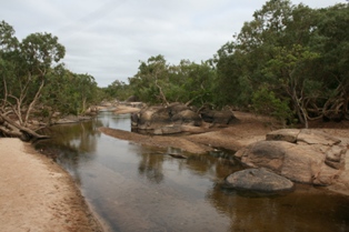
Cape Tribulation is a headland and coastal locality in the Shire of Douglas in northern Queensland, Australia. In the 2021 census, Cape Tribulation had a population of 123 people.

Injinoo is a coastal town in the Northern Peninsula Area Region and a locality split between Northern Peninsula Area Region and the Shire of Torres in Far North Queensland, Australia. It is on the north-western coast of Cape York Peninsula. In the 2016 census, Injinoo had a population of 561 people.

Bloomfield is a town in the Shire of Cook and a coastal locality which is split between the Shire of Cook and the Shire of Douglas in Queensland, Australia. The neighbourhood of Ayton is within the locality. In the 2016 census, Bloomfield had a population of 204 people.

Palmer is a rural locality in the Shire of Cook, Queensland, Australia. In the 2021 census, Palmer had a population of 46 people.

Dixie is a rural locality in the Shire of Cook, Queensland, Australia. In the 2021 census, Dixie had a population of 43 people.
Archer River is a rural locality in the Shire of Cook, Queensland, Australia. In the 2021 census, Archer River had a population of 27 people.
Edward River is a rural locality in the Shire of Cook, Queensland, Australia. In the 2021 census, Edward River had a population of 3 people.
Nicholson is a coastal locality in the Shire of Burke, Queensland, Australia. It is on the border with the Northern Territory. In the 2021 census, Nicholson had a population of 32 people.
Jardine is a rural locality in the Livingstone Shire, Queensland, Australia. In the 2021 census, Jardine had a population of 72 people.
Mission River is a coastal rural locality split between the Shire of Cook and the Aboriginal Shire of Napranum in Queensland, Australia. In the 2016 census, Mission River had a population of 987 people.
Shelburne is a northern coastal locality in the Shire of Cook, Queensland, Australia. In the 2021 census, Shelburne had a population of 44 people.
Maramie is a locality in the Shire of Carpentaria, Queensland, Australia. In the 2021 census, Maramie had a population of 28 people.
Gangalidda is a coastal locality in the Aboriginal Shire of Doomadgee, Queensland, Australia, on the Gulf of Carpentaria. In the 2021 census, Gangalidda had "no people or a very low population".
Holroyd River is a locality in the Shire of Cook, Queensland, Australia. In the 2021 census, Holroyd River had a population of 4 people.
Dedin is an undeveloped locality in the Shire of Douglas, Queensland, Australia. In the 2021 census, Dedin had "no people or a very low population".
Garrawalt is a rural locality in the Shire of Hinchinbrook, Queensland, Australia.
Highbury is a rural locality in the Shire of Mareeba, Queensland, Australia. In the 2021 census, Highbury had a population of 9 people.
Bolwarra is a rural locality in the Shire of Mareeba, Queensland, Australia. In the 2021 census, Bolwarra had "no people or a very low population".
Bulleringa is a rural locality in the Shire of Mareeba, Queensland, Australia. In the 2021 census, Bulleringa had "no people or a very low population".
Prince Of Wales is an island locality in the Shire of Torres, Queensland, Australia. In the 2021 census, the locality of Prince Of Wales had a population of 62 people.
