North Eleuthera Airport

Last updated

North Eleuthera Airport
Summary
Airport typePublic
LocationNorth Eleuthera
Elevation  AMSL 13 ft / 4 m
Coordinates 25°28′30″N076°41′01″W / 25.47500°N 76.68361°W / 25.47500; -76.68361
Map
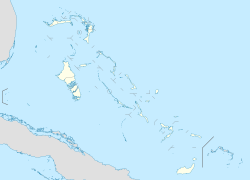
Bahamas location map.svg
Airplane silhouette.svg
MYEH
Location in The Bahamas
Runways
Direction LengthSurface
mft
07/251,8356,020Asphalt
Source: DAFIF [1]

North Eleuthera Airport is an airport in North Eleuthera on Eleuthera in the Bahamas ( IATA : ELH, ICAO : MYEH). It serves the outlying islands of Harbour Island and Spanish Wells as well as the northernmost third of Eleuthera Island.
Contents

Airlines and destinations

Passenger

AirlinesDestinations
American Eagle Charlotte, Miami
Bahamasair Governor's Harbour, Nassau, Rock Sound
Delta Connection Atlanta
Pineapple Air Governor's Harbour, Nassau
Silver Airways Fort Lauderdale, Orlando
Southern Air Charter Nassau

Related Research Articles

<span class="mw-page-title-main">Eleuthera</span> Island in the Bahamas

Eleuthera refers both to a single island in the archipelagic state of The Commonwealth of the Bahamas and to its associated group of smaller islands. Eleuthera forms a part of the Great Bahama Bank. The island of Eleuthera incorporates the smaller Harbour Island. "Eleuthera" derives from the feminine form of the Greek adjective ἐλεύθερος (eleútheros), meaning "free". Known in the 17th century as Cigateo, it lies 80 km east of Nassau. It is long and thin—180 km long and in places little more than 1.6 km wide. Its eastern side faces the Atlantic Ocean, and its western side faces the Great Bahama Bank. The topography of the island varies from wide rolling pink sand beaches to large outcrops of ancient coral reefs, and its population is approximately 11,000. The principal economy of the island is tourism.

<span class="mw-page-title-main">Ragged Island, Bahamas</span> Island in Bahamas

Ragged Island is a 23 km2 (8.9 sq mi) island and district in the southern Bahamas. Ragged Island is part of the Jumentos Cays and Ragged Island Chain. The crescent-shaped chain measures over 180 km (110 mi) in length and includes cays known as Raccoon Cay, Hog Cay and Double-Breasted Cay. Island ownership is stated to have been granted to William George Lockhart some time in the 18th century. On 8 September 2017, Duncan Town took a direct hit from hurricane Irma.

<span class="mw-page-title-main">Harbour Island, Bahamas</span> Island and district in Bahamas

Harbour Island is an island and administrative district in the Bahamas and is located off the northeast coast of Eleuthera Island. It has a population of 1,762.

<span class="mw-page-title-main">North Eleuthera</span>

North Eleuthera is one of the districts of the Bahamas, on the island of Eleuthera. It has a population of 3,247.

<span class="mw-page-title-main">South Eleuthera</span>

South Eleuthera is one of the districts of the Bahamas, on the island of Eleuthera.

<span class="mw-page-title-main">Spanish Wells</span> Place in St. Georges Cay, Bahamas

Spanish Wells is a district of the Bahamas. The settlement consists of a medium-sized town on the island of St. George's Cay 610 m (2,000 ft) wide by 2,860 m (9,380 ft) long, located approximately 500 m (1,600 ft) off the northern tip of Eleuthera island. According to the 2010 census, it has a population of 1,551 residents.

Lynx Air International was a United States airline based in Fort Lauderdale, Florida, USA.

Freetown is an area in the Bahamas located on the island of Eleuthera. As of 2018, it had a population of about 100.

Southern Air Charter is an airline and air charter company, operating in the Bahamas. They mainly fly air charters, but the airline does offer some scheduled inter-island services between destinations in the Bahamas.

Governor's Harbour Airport is an airport in Governor's Harbour on Eleuthera in the Bahamas. It is the second most active of the three airports on Eleuthera, and is about 8 mi (13 km) north of the city.

Rock Sound International Airport is an airport in the South Eleuthera district of The Bahamas. Its name comes from the former district of Rock Sound.

<span class="mw-page-title-main">Effects of Hurricane Andrew in The Bahamas</span>

The effects of Hurricane Andrew in the Bahamas included three direct fatalities and $250 million (1992 USD) in damage. Forming from a tropical wave on August 16, Andrew remained weak until rapidly intensifying on August 22, and late on August 23 it made its first landfall in The Bahamas on Eleuthera as a Category 5 hurricane with winds of 260 km/h (160 mph); early the next day Hurricane Andrew passed through the southern Berry Islands with winds of 240 km/h (150 mph). The hurricane later made a devastating landfall in southern Florida, and after striking southern Louisiana it dissipated over the eastern United States. Andrew was the first major hurricane to affect the nation since Hurricane Betsy in 1965. It caused $250 million in damage, with damage heaviest on Eleuthera and Cat Cay. Four deaths occurred due to the storm, of which one was indirectly related to the hurricane.

<span class="mw-page-title-main">Outline of the Bahamas</span> Overview of and topical guide to The Bahamas

The following outline is provided as an overview of and topical guide to The Bahamas:

<span class="mw-page-title-main">Index of the Bahamas–related articles</span>

The following is an alphabetical list of topics related to the Commonwealth of The Bahamas.

Florida Coastal Airlines (FCA) was an airline based in Fort Lauderdale, Florida, USA. It operated services between Florida and the Bahamas, Cuba, and Haiti.

Cape Eleuthera Airport was a public use airport located 3 nm east-southeast of Cape Eleuthera, The Bahamas. The airport is closed, and the runway is not usable.

Pineapple Air is an airline based in Nassau, Bahamas.

References

  1. "Airport information for MYEH". World Aero Data. Archived from the original on 5 March 2019.{{cite web}}: CS1 maint: unfit URL (link) Data current as of October 2006. Source: DAFIF.