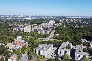
St. Lawrence is a neighbourhood located in downtown Toronto, Ontario, Canada. The area, a former industrial area, is bounded by Yonge, Front, and Parliament Streets, and the Canadian National railway embankment. The Esplanade off Yonge St., lined with restaurants, cafés and hotels runs through the middle of the area. In previous times, the area was sometimes referred to as 'St. Lawrence Ward' or more often today as 'St. Lawrence Market', synonymous with the large retail vendor market which is the neighbourhood's focal point. The area is the site of a large city-sponsored housing project of the 1970s, which revitalized an old brownfields area. The boundaries of the St Lawrence Neighbourhood Association and the St Lawrence Market BIA are somewhat larger than those noted above. Both groups have boundaries that extend from Yonge to Parliament Streets and Queen Street East to the rail corridor.

Harbourfront is a neighbourhood on the northern shore of Lake Ontario within the downtown core of the city of Toronto, Ontario, Canada. Part of the Toronto waterfront, Harbourfront extends from Bathurst Street in the west, along Queens Quay, with its ill-defined eastern boundary being either Yonge Street or York Street. Its northern boundary is the Gardiner Expressway. Much of the district was former water lots filled in during the early 1900s to create a larger harbour district. After shipping patterns changed and the use of the Toronto harbour declined, the area was converted from industrial uses to a mixed-use district that is mostly residential and leisure.

The Toronto waterfront is the lakeshore of Lake Ontario in the city of Toronto, Ontario, Canada. It spans 46 kilometres between the mouth of Etobicoke Creek in the west and the Rouge River in the east.

Parkdale—High Park is a federal electoral district in Ontario, Canada, that has been represented in the House of Commons of Canada since 1979. It was created during the 1976 electoral boundaries redistribution from parts of Parkdale, High Park—Humber Valley, Davenport and Spadina districts. As of the October 19, 2015, Canadian general election, the current Member of Parliament (MP) is Liberal member Arif Virani. According to the 2016 Census, Parkdale—High Park has the lowest percentage of visible minorities (26.2%) among all City of Toronto ridings; it also has the highest percentage of people of Irish (20.0%), German (9.8%), and French (8.9%) ethnic origin of all City of Toronto ridings.

False Creek is a short narrow inlet in the heart of Vancouver, separating the Downtown and West End neighbourhoods from the rest of the city. It is one of the four main bodies of water bordering Vancouver, along with English Bay, Burrard Inlet, and the Fraser River. Granville Island is located within the inlet.

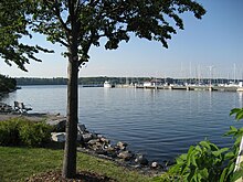
Toronto Harbour or Toronto Bay is a bay on the north shore of Lake Ontario, in Toronto, Ontario, Canada. It is a natural harbour, protected from Lake Ontario waves by the Toronto Islands. Today, the harbour is used primarily for recreational boating, including personal vessels and pleasure boats providing scenic or party cruises. Ferries travel from docks on the mainland to the Islands, and cargo ships deliver aggregates and raw sugar to industries located in the harbour. Historically, the harbour has been used for military vessels, passenger traffic and cargo traffic. Waterfront uses include residential, recreational, cultural, commercial and industrial sites.
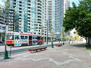
Queens Quay is a prominent street in the Harbourfront neighbourhood of Toronto, Ontario, Canada. The street was originally commercial in nature due to the many working piers along the waterfront; parts of it have been extensively rebuilt in since the 1970s with parks, condominiums, retail, as well as institutional and cultural development.

Sunnyside is a lakefront district in Toronto, Ontario, Canada. It includes a beach and park area along Lake Ontario's Humber Bay, from west of Exhibition Place to the mouth of the Humber River. The area has several recreation uses, including rowing clubs, sports clubs, picnic areas, playgrounds, a nightclub, a bathing pavilion and public pool. The area is a 3 kilometres (1.9 mi) long strip along the lakeshore, bounded by the Gardiner Expressway and rail lines, which separate it from the Parkdale, Roncesvalles and Swansea neighbourhoods to the north. The name originates in a local farm owned by John Howard, which was situated just to the north, on the location of the current St. Joseph's Health Centre hospital.
O'Connor–Parkview is a neighbourhood in the East York area of Toronto, Ontario, Canada. While the name is taken from the definition used by the city of Toronto, local residents are more familiar with the niche areas that define the larger neighbourhood. It is a very diverse neighbourhood that includes English-speakers and Greeks in the west, to the Tamil speakers in the east and Bengali people in the south. It includes low-income highrises, to huge property lots. The smaller areas included inside the neighbourhood are Topham Park, Woodbine Gardens and Parkview Hills.

The Queensway–Humber Bay, known officially as Stonegate–Queensway, is a neighbourhood in the southwest of Toronto, Ontario, Canada. It is located in the southeast area of the former City of Etobicoke.

Bay Street is a lower city arterial road in Hamilton, Ontario, Canada. It starts at Inglewood Drive, just South of Aberdeen Avenue, as a collector road with only two lanes, then eventually becomes a six lane thoroughfare at its peak. Bay Street also passes through downtown Hamilton, where many high-rise buildings are found. Bay Street is a one-way street from Aberdeen Avenue to Cannon Street West. Bay Street continues as an arterial route to Strachan Street, where it is downgraded to a neighbourhood collector and eventually ends at a curb at Pier 4 Park at Burlington Street in the city's North End.

Hughson Street is a Lower City collector road in Hamilton, Ontario, Canada. It starts at Charlton Avenue East at St. Joseph's hospital and runs north to Haymarket Street in the downtown where it's cut off by the Hamilton GO Transit station. Up to this point it is a two-way street. It then starts up again north of the station on Hunter Street East, where it then becomes a one-way street going north just past Barton Street East to Murray Street where it's cut off again by a parking lot for LIUNA Station. It then starts up again one block north past the CN railway tracks on Strachan Street and from this point onwards becomes a two-way street again that extends to the city's North End to the waterfront on Guise Street West, the site of the Canada Marine Discovery Centre and Pier 9.

James Street is a Lower City arterial road in Hamilton, Ontario, Canada. It starts off at the base of the Niagara Escarpment from James Mountain Road, a mountain-access road in the city. It was one of many arterials in the central business district converted to one-way operation in 1956 when the city retained Wilbur Smith and Associates to develop a Traffic and Transportation Plan. Parts of it were restored to two-way operation in 2002. It extends north to the city's waterfront at the North End where it ends at Guise Street West right in front of the Harbour West Marina Complex and the Royal Hamilton Yacht Club.
Pier 4 Park is a 2.4 hectare park found in the west-end of Hamilton Harbour near Bay Street North in Hamilton, Ontario, Canada.

Bayfront Park is a 16-hectare (40-acre) park found in the West-end of Hamilton Harbour in the North End neighbourhood of Hamilton, Ontario, Canada.
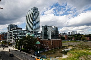
East Bayfront, or the East Bayfront Precinct, is an emerging neighbourhood in Toronto, Ontario, Canada. It is currently undergoing a transformation from industrial use to mixed-use as part of Waterfront Toronto's plans to create a residential and commercial district urban core near the lake.

West Harbour GO Station is a regional rail station in the North End neighbourhood of Hamilton, Ontario, Canada. The station has been served by GO Transit's Lakeshore West line since July 9, 2015. There is hourly service between West Harbour and Toronto's Union Station, seven days a week. Via Rail service may eventually be provided.

The Esplanade is an east-west street along the central waterfront of Toronto, Ontario, Canada. Originally conceived as a city beautification project to clean up the city's waterfront in the 1850s, the street was taken over by the coming of the railways to Toronto in 1850. The railway eventually moved to an elevated viaduct, leaving only the eastern section of the street today. The area, east of Yonge Street, was dominated by industrial uses until the second half of the 20th century. As the harbour declined as a transfer point, the railway and industrial uses left the area. The Esplanade was redeveloped into a residential area, known as the "St. Lawrence Neighbourhood" in the late 1970s and early 1980s. This neighbourhood consists of generally low-rise and mid-rise housing - condominiums, public housing, cooperatives and some town homes between Jarvis and Parliament Streets south of Front Street. In the blocks between Jarvis and Parliament, the southern part of the street were converted to a long strip of park and recreation space for the residents - David Crombie Park. The stretch between Scott Street and Market Street is a popular restaurant area.