
Harbourfront is a neighbourhood on the northern shore of Lake Ontario within the downtown core of the city of Toronto, Ontario, Canada. Part of the Toronto waterfront, Harbourfront extends from Bathurst Street in the west, along Queens Quay, with its ill-defined eastern boundary being either Yonge Street or York Street. Its northern boundary is the Gardiner Expressway. Much of the district was former water lots filled in during the early 1900s to create a larger harbour district. After shipping patterns changed and the use of the Toronto harbour declined, the area was converted from industrial uses to a mixed-use district that is mostly residential and leisure.

The Toronto waterfront is the lakeshore of Lake Ontario in the city of Toronto, Ontario, Canada. It spans 46 kilometres between the mouth of Etobicoke Creek in the west and the Rouge River in the east.

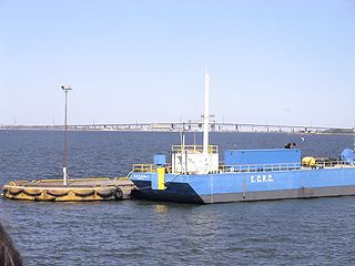
Toronto Harbour or Toronto Bay is a natural bay on the north shore of Lake Ontario, in Toronto, Ontario, Canada. Today, the harbour is used primarily for recreational boating, including personal vessels and pleasure boats providing scenic or party cruises. Ferries travel from docks on the mainland to the Islands, and cargo ships deliver aggregates and raw sugar to industries located in the harbour. Historically, the harbour has been used for military vessels, passenger traffic and cargo traffic. Waterfront uses include residential, recreational, cultural, commercial and industrial sites.
Hamilton Harbour lies on the western tip of Lake Ontario, bounded on the northwest by the City of Burlington, on the south by the City of Hamilton, and on the east by Hamilton Beach and Burlington Beach. It is joined to Cootes Paradise by a narrow channel formerly excavated for the Desjardins Canal. Within Hamilton itself, it is referred to as "Hamilton Harbour", "The Harbour" and "The Bay". The bay is naturally separated from Lake Ontario by a sand bar. The opening in the north end was filled in and channel cut in the middle for ships to pass. The Port of Hamilton is on the Hamilton side of the harbour.

The Scarborough Bluffs, also known as The Bluffs, is an escarpment in the Scarborough district of Toronto, Ontario, Canada. There are nine parks along the bluffs, with Bluffers Park being the only one with a beach. Forming much of the eastern portion of Toronto's waterfront, the Scarborough Bluffs stands above the shoreline of Lake Ontario. At its highest point, the escarpment rises 90 metres (300 ft) above the coastline and spans a length of 15 kilometres (9.3 mi).

Sunnyside is a lakefront district in Toronto, Ontario, Canada. It includes a beach and park area along Lake Ontario's Humber Bay, from west of Exhibition Place to the mouth of the Humber River. The area has several recreation uses, including rowing clubs, sports clubs, picnic areas, playgrounds, a nightclub, a bathing pavilion and public pool. The area is a 3 kilometres (1.9 mi) long strip along the lakeshore, bounded by the Gardiner Expressway and rail lines, which separate it from the Parkdale, Roncesvalles and Swansea neighbourhoods to the north. The name originates in a local farm owned by John Howard, which was situated just to the north, on the location of the current St. Joseph's Health Centre hospital.
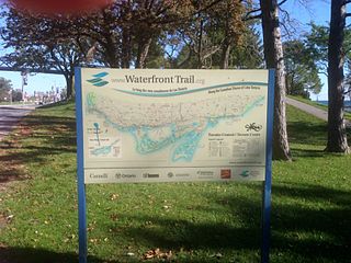
Stretching over 3600 km from Prince Township, west of Sault Ste. Marie, to the Quebec border, the Great Lakes Waterfront Trail is a signed route of interconnecting roads and off-road trails joining over 150 communities and First Nations along the Canadian shores of the Great Lakes and St. Lawrence River. A celebration of nature and culture, the Great Lakes Waterfront Trail is part of a strategy to protect and connect people to the largest group of freshwater lakes on earth. It is a legacy project of the Waterfront Regeneration Trust, a charity, and its community partners. Through Toronto, the trail is called the Martin Goodman Trail. The Waterfront Trail is also used by commuters in parts of Southern Ontario.

Humber Bay Park is a waterfront park located in Etobicoke, part of Toronto, Ontario, Canada. The park consists of two landspits situated at the mouth of Mimico Creek. The park is south of Lake Shore Boulevard West, near Park Lawn Road. Humber Bay Park East is 19 hectares, while Humber Bay Park West is 120 hectares.

Bay Street is a lower city arterial road in Hamilton, Ontario, Canada. It starts at Inglewood Drive, just South of Aberdeen Avenue, as a collector road with only two lanes, then eventually becomes a six lane thoroughfare at its peak. Bay Street also passes through downtown Hamilton, where many high-rise buildings are found. Bay Street is a one-way street from Aberdeen Avenue to Cannon Street West. Bay Street continues as an arterial route to Strachan Street, where it is downgraded to a neighbourhood collector and eventually ends at a curb at Pier 4 Park at Burlington Street in the city's North End.

Hughson Street is a Lower City collector road in Hamilton, Ontario, Canada. It starts at Charlton Avenue East at St. Joseph's hospital and runs north to Haymarket Street in the downtown where it's cut off by the Hamilton GO Transit station. Up to this point it is a two-way street. It then starts up again north of the station on Hunter Street East, where it then becomes a one-way street going north just past Barton Street East to Murray Street where it's cut off again by a parking lot for LIUNA Station. It then starts up again one block north past the CN railway tracks on Strachan Street and from this point onwards becomes a two-way street again that extends to the city's North End to the waterfront on Guise Street West, the site of the Canada Marine Discovery Centre and Pier 9.

MacNab Street is a Lower City collector road in Hamilton, Ontario, Canada. It starts in the Durand neighbourhood on Markland Street, as a one-way street going north to Bold Street, where it becomes two-way for one block until Hurst Place where it's cut off by a wall for the Hunter Street railway bridge. Pedestrians may cross Hunter Street at an underpass. MacNab Street starts again north of the Railway line on Hunter Street as a two-way street but is cut off again at King Street where the Lloyd D. Jackson Square mall and Stelco Tower are situated. MacNab Street continues north of this Mall on York Boulevard, in front of the Hamilton Public Library & the entrance to the Hamilton Farmer's Market, again as a two-way street right through the city's North End to Burlington Street. It continues as a one-way street to the waterfront where it ends at Guise Street West, the site of the Royal Hamilton Yacht Club and Pier 5.

York Boulevard is a Lower City arterial road in Hamilton, Ontario, Canada. Formerly known as Highway 2 and Highway 6, it starts in Burlington, Ontario, at Plains Road West as a two-way arterial road that wraps around and over Hamilton Harbour, enters the city of Hamilton in the west end at Dundurn Park, and ends at James Street North. It has a one-way section from Queen Street to Bay Street North, and continues east of James Street North as Wilson Street.)

The Royal Hamilton Yacht Club (RHYC) is located in Hamilton, Ontario, Canada, at the west end of Lake Ontario, and has been in existence since 1888. When the yacht club first opened, it was located on the Burlington Canal, along the beach strip that separates Burlington Bay from Lake Ontario. It later moved to the foot of Bay Street. Since its founding in 1888, RHYC has promoted local and international yacht racing. Its current general manager is Katrina Lewis.

The Palace Pier is the site of Palace Place and Palace Pier, two cruciform condominium towers tied for the 45th-tallest building in Toronto, Ontario, Canada. They are located at 2045 Lake Shore Boulevard West and 1 Palace Pier Court in the Humber Bay neighbourhood in the former city of Etobicoke.

Beach Boulevard is a Lower city street in Hamilton, Ontario, Canada, east of the Hamilton Harbour on a thin piece of land that crosses over Lake Ontario and stretches from where Woodward Avenue becomes Eastport Drive in the south to near the Lift Bridge in the north at Eastport Drive (again). It runs parallel with the QEW and the Burlington Bay James N. Allan Skyway Bridge.
Pier 4 Park is a 2.4 hectare park found in the west-end of Hamilton Harbour near Bay Street North in Hamilton, Ontario, Canada.

The Royal Vancouver Yacht Club (RVYC) is a yacht club located in Vancouver, British Columbia. Royal Vancouver Yacht Club currently operates two marinas, the one at Jericho Beach in English Bay and another in Coal Harbour. The Jericho site includes a clubhouse, two restaurants, and berths enough for 350 as well as a dinghy dock. In 2017 the award-winning Dock Building was completed, designed by Michael Green Architecture, providing offices for the Harbour Master, instruction and amenity space and workshops to maintain boats, sails, and gear. The Coal Harbour site has approximately 350 berths, some with covered moorage, and is the location of the floating restaurant called The Mermaid. The club also has seven offshore stations in BC waters.
East Bayfront, or the East Bayfront Precinct, is an emerging neighbourhood in Toronto, Ontario, Canada. It is currently undergoing a transformation from industrial use to mixed-use as part of Waterfront Toronto's plans to create a residential and commercial district urban core near the lake.
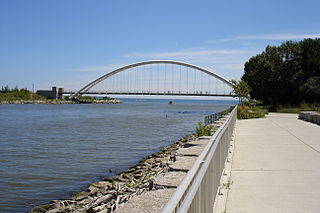
The Martin Goodman Trail is a 56 km (35 mi) multi-use path along the waterfront in Toronto, Ontario, Canada. It traverses the entire lake shore from one end of the city to the other, from Humber Bay Arch Bridge in the west to the Rouge River in the east. The Martin Goodman Trail is part of the 730 km Waterfront Trail around Lake Ontario.
Amet Sound is a large body of water, an embayment of the Northumberland Strait, on the north shore Nova Scotia straddling Colchester and Pictou counties. It takes its name from Amet Island, a small island just beyond the mouth of the sound in Northumberland Strait. Because of its sheltered position, its bays and harbours are considered "safe haven" for yachts in the event of major storms.


