Transport in Hamilton, Ontario consists of a variety of modes.
Transport in Hamilton, Ontario consists of a variety of modes.
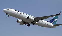
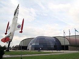
John C. Munro Hamilton International Airport, located on the tip of Hamilton Mountain at Mount Hope in the former Glanbrook Township, is the busiest air cargo hub in Canada. WestJet, for several years up until 2010 used the airport as their primary point of access to Southern Ontario over the more expensive Toronto Pearson International Airport. The airport is a major lower-cost alternative to Pearson for cargo air service. It is also home to the Canadian Warplane Heritage Museum. [1] Currently the Airport needs 10 km2 of new employment land to handle its growth for the next 25 years; farmland around the airport is the best option available. A report by Hemson Consulting [2] says the city will need greenfields the size of the Royal Botanical Gardens on which to locate businesses that will generate an estimated 59,000 jobs by 2031. Aerotropolis, a proposed 10.5 km2 industrial park at Highway 6 and 403, has been a hotly debated issue at Hamilton City Hall for years. Opponents feel the city needs to do more investigation about the cost to taxpayers before embarking on the project. [3]
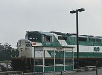
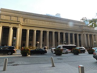
Canadian National Railways (CN) serves Hamilton for lifting and setting off traffic for the Rail America (Southern Ontario Railway Shortline), but as heavy industry declined and the preferred mode of transportation changed to road, the number of branch lines and feeder tracks has declined dramatically. Until the early 1970s, the Toronto, Hamilton and Buffalo Railway offered passenger service. Since the late 1980s, GO Transit has offered sporadic passenger train service from its James Street North station. In the late 1990s, GO Transit operations were consolidated at the refurbished Art Deco building on Hunter Street which formerly served the Toronto, Hamilton and Buffalo service. GO trains and buses serve a population of six million in an 8,000 km2 area (3,000 sq.mi.) radiating from Downtown Toronto to Hamilton and Guelph in the west; Orangeville, Barrie, and Beaverton to the north; and Port Perry, Oshawa, and Newcastle in the east. The buses extend GO's service as far as over 100 km (about 60 miles) from Downtown Toronto. GO connects with every municipal transit system in the Greater Toronto and Hamilton areas, including the Toronto Transit Commission (TTC). The TH&B station retains its name today, at the GO Transit network located in the heart of Hamilton's downtown core. The nearest Via Rail Canada station is at Aldershot GO Station in west Burlington.
Hamilton has good bus connections with cities in southern Ontario. GO Transit offers frequent and reliable express bus service to Toronto, now from Hamilton GO Centre and formerly from Rebecca Street.
Within the city, the Hamilton Street Railway offers good service in the lower city (especially on east-west routes), reduced service on the Mountain and skeletal service outside the old city of Hamilton (except for Dundas, which is served about as well as the Mountain). The name is a legacy of the days when the majority of public transit vehicles were streetcars; the present-day Hamilton Street Railway is in fact built around bus services. Burlington Transit also serves Burlington via York Boulevard and the former Highway 2, and HSR connects downtown Burlington under the Burlington Skyway Bridge.

The following controlled access highways and expressways serve Hamilton, Ontario:
All of the old city of Hamilton is on a broken great grid pattern, with major north-south streets spaced approximately one half-mile apart and major east-west streets generally spaced six tenths of a mile apart - thus enclosing 160 acre concessions. Great grid streets on the Mountain bear the name of their lower city counterparts with the prefix "Upper" except for Garth Street, which would be Upper Dundurn Street if the pattern held.
East-west streets on the central and east Mountain are pretty regular, while those in the lower city (especially major ones) and west Mountain are very irregular. King and Main Streets run approximately parallel to one another though they intersect at The Delta. They are usually one-way streets in opposite directions, so they are best conceptualized as a single very wide boulevard and are envied by other Ontario cities for their usually efficient flow of traffic.
However, some contend that the very efficiency that makes driving easy discourages pedestrian street life and hurts downtown businesses. Streets that have recently converted from one-way to two-way, like James Street North, have enjoyed a resurgence in local business, reinvestment in buildings, and improving economic activity.
Mountain Accesses in the city of Hamilton include the following: [4]
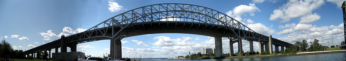
There are 389 Bridges and culverts in Hamilton including 25 bridges being built for the Red Hill Valley Parkway. Total Replacement value is more than $350-million. Hamilton has the second largest number of municipal bridges in Ontario. Up to $6-million is spent annually on bridge projects.
22-point inspections (including the deck, hand railings, expansion joints, approaches and substructure) are conducted every two years by engineering firms. The Mary Street bridge is closed to vehicle traffic and will become a pedestrian bridge once a Ferguson Avenue bridge is completed. The Ray Street pedestrian bridge north of Hunter Street was closed after an inspection.
As of 8 January 2007, Dundurn Street South is closed between Main Street West and Hill Street until the end of June 2007 while Canadian Pacific Railway replaces the bridge nearest Main Street. The city of Hamilton and CPR are splitting the $2.2-million cost. [6] On June 27, 2007, One half of the Aberdeen Avenue bridge over Highway 403 was closed for emergency repairs because a hole appeared in the deck. [7]
On July 25, 2008, a newly constructed bridge opened up on Ferguson Avenue North, just north of Barton Street East, to Simcoe Street East. This part of Ferguson was separated by CN railway tracks and better connects the downtown to Hamilton's waterfront. The $4.6 million construction project began in November 2006 and includes one lane of traffic in each direction, bicycle lanes and sidewalks. This project is also in line with Hamilton’s recently adopted Transportation Master Plan which emphasizes enhanced cycling and walking facilities and an efficient road network to support economic development. This construction project received federal funding through the Federal Gas Tax Fund. [8] [9] [10]
The Queen Elizabeth Way (QEW) is a 400-series highway in the Canadian province of Ontario linking Toronto with the Niagara Peninsula and Buffalo, New York. The freeway begins at the Peace Bridge in Fort Erie and travels 139.1 kilometres (86.4 mi) around the western end of Lake Ontario, ending at Highway 427 in Toronto. The physical highway, however, continues as the Gardiner Expressway into downtown Toronto. The QEW is one of Ontario's busiest highways, with an average of close to 200,000 vehicles per day on some sections. Major highway junctions are at Highway 420 in Niagara Falls, Highway 405 in Niagara-on-the-Lake, Highway 406 in St. Catharines, the Red Hill Valley Parkway in Hamilton, Highway 403 and Highway 407 in Burlington, Highway 403 at the Oakville–Mississauga boundary, and Highway 427 in Etobicoke. Within the Regional Municipality of Halton the QEW is signed concurrently with Highway 403. The speed limit is 100 km/h (62 mph) throughout most of its length, with the exceptions being between Hamilton and St. Catharines where the posted limit is 110 km/h (68 mph).
The Don Valley Parkway (DVP) is a municipal expressway in Toronto, Ontario, Canada, which connects the Gardiner Expressway in downtown Toronto with Highway 401. North of Highway 401, it continues as Highway 404. The parkway runs through the parklands of the Don River valley, after which it is named. It has a maximum speed limit of 90 km/h (56 mph) for its entire length of 15.0 km (9.3 mi). It is six lanes for most of its length, with eight lanes north of York Mills Road and four lanes south of Eastern Avenue. As a municipal road, it is patrolled by the Toronto Police Service.

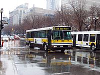
The Hamilton Street Railway commonly known as the HSR is a public transport agency in Hamilton, Ontario, Canada. The name is a legacy of the company's early period, when public transit in Hamilton was primarily served by streetcars. Although streetcars are no longer used in the city today, the HSR operates bus and paratransit services, with a ridership of 21 million passengers a year. The HSR uses the Presto card as its method of fare payment, allowing for connections with GO Transit and other transit systems in the Greater Toronto area.
King's Highway 403, or simply Highway 403, is a 400-series highway in the Canadian province of Ontario that travels between Woodstock and Mississauga, branching off from and reuniting with Highway 401 at both ends and travelling south of it through Hamilton and Mississauga. It is concurrent with the Queen Elizabeth Way (QEW) for 22 km (14 mi) from Burlington to Oakville. The Highway 403 designation was first applied in 1963 to a short stub of freeway branching off the QEW, and the entire route was completed on August 15, 1997, when the section from Brantford to the then-still independent Town of Ancaster was opened to traffic. The section of Highway 403 between Woodstock and Burlington was formally dedicated as the Alexander Graham Bell Parkway on April 27, 2016, in honour of Alexander Graham Bell.

Burlington Transit is the public transport provider in the city of Burlington, Ontario, Canada. Services began in September 1975, after the city had been served by neighbouring systems including Hamilton Street Railway (HSR) and former subsidiary Canada Coach Lines, as well as "local" services to and from Toronto once provided by Gray Coach Lines and GO Transit along Lakeshore Road.

The cancelled expressways in Toronto were a planned series of expressways in Toronto, Ontario, Canada that were only partially built or cancelled due to public opposition. The system of expressways was intended to spur or handle growth in the suburbs of Toronto, but were opposed by citizens within the city of Toronto proper, citing the demolition of homes and park lands, air pollution, noise and the high cost of construction. The Spadina Expressway, planned since the 1940s, was cancelled in 1971 after being only partially constructed. After the Spadina cancellation, other expressway plans, intended to create a 'ring' around the central core, were abandoned.

Dufferin Street is a major north–south street in Toronto, Vaughan and King, Ontario, Canada. It is a concession road, two concessions (4 km) west of Yonge Street. The street starts at Exhibition Place, continues north to Toronto's northern boundary at Steeles Avenue with some discontinuities and continues into Vaughan, where it becomes York Regional Road 53. The street is named for Frederick Hamilton-Temple-Blackwood, 1st Marquess of Dufferin and Ava, who served as Governor General of Canada from 1872 to 1878. Prior to 1878 the street was labelled as Western City Limits or Sideline Road south off Bloor. In 2003 and 2007, it was voted as one of "Ontario's Worst 20 Roads" in the Ontario's Worst Roads poll organized by the Canadian Automobile Association.
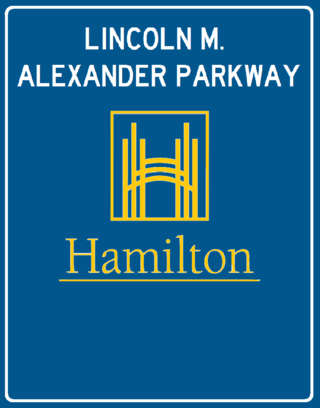
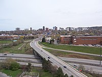
The Lincoln Alexander Parkway, nicknamed The Linc, is a municipal expressway in the city of Hamilton, Ontario, Canada, which connects Highway 403 with the Red Hill Valley Parkway, which continues north to the Queen Elizabeth Way (QEW). Collectively, the two expressways form a southern and eastern bypass of Hamilton. Located on the Hamilton mountain, atop the Niagara Escarpment, the freeway was named after the former Progressive Conservative MP and first black Lieutenant Governor of Ontario, Lincoln Alexander in July 1997, despite him never holding a driver's license.

Aldershot GO Station is a railway station and bus station used by Via Rail and GO Transit, located at Highway 403 and Waterdown Road in the Aldershot community of Burlington, Ontario, Canada.

Hamilton GO Centre is a commuter rail station and bus terminal in downtown Hamilton, Ontario, Canada. As the terminal stop for evening rush-hour Lakeshore West line trains, it is a major hub for GO Transit bus and train services.
Transportation in the Canadian city of Toronto forms the hub of the road, rail and air networks in the Greater Toronto Area and much of southern Ontario. There are many forms of transport in the city, including railways, highways, and public transit. Toronto also has an extensive network of bicycle lanes and multi-use trails and paths.

King Street is a Lower City arterial road in Hamilton, Ontario, Canada, also known as Highway 8. The western-end starts off beside McMaster University Medical Centre as a two-way street and passes through Westdale. At Paradise Road, King Street switches over to a one-way street (westbound) right through the city's core up to "the Delta", a spot in town where King and Main streets intersect. From the Delta onwards, King Street then switches over to become a two-way street again and ends at Highway 8 in Stoney Creek.
Hunter Street is a Lower City collector road in Hamilton, Ontario, Canada. It is a one-way street (Westbound) that starts West of Locke Street at Hill Street Park and ends two blocks East of Victoria Avenue at Emerald Street. Hunter Street is a two-way street between Victoria and Emerald Streets.

Concession Street is an Upper City (mountain) arterial road in Hamilton, Ontario, Canada. It starts at Belvidere Avenue, just west of Sam Lawrence Park, and extends eastward past Mountain Drive Park on Upper Gage Avenue and ends shortly thereafter at East 43rd Street.
The CN Halton Subdivision is a major railway line in Southern Ontario, Canada. It is owned and operated by the Canadian National Railway (CN).
MoveOntario 2020 was a 2007 plan proposed by the Government of Ontario that would fund 52 rapid-transit projects throughout the Greater Toronto and Hamilton Area in Ontario, Canada. It was succeeded by The Big Move and GO Transit's Go 2020.

The Hurontario LRT is a light rail line under construction in the cities of Mississauga and Brampton, Ontario, Canada. The line will run along Hurontario Street from Mississauga's Port Credit neighbourhood north to Steeles Avenue in Brampton. The line will be built and operated as a public-private partnership by Mobilinx, a consortium of private European and Japanese companies, with provincial transit agency Metrolinx retaining ownership of the line. It will be the only street railway operating in the Greater Toronto Area outside Toronto proper.
Public transportation in the Canadian city of Toronto dates back to 1849 with the creation of a horse-drawn stagecoach company. Today, Toronto's mass transit is primarily made up of a system of subways, buses, and streetcars, covering approximately 1,200 km (750 mi) of routes operated by the Toronto Transit Commission (TTC) and inter-regional commuter rail and bus service provided by GO Transit.