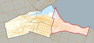
Hamilton is located on the western end of the Niagara Peninsula and wraps around the westernmost part of the Lake Ontario. Most of the city including the downtown section lies along the south shore. Situated in the geographic centre of the Golden Horseshoe, it lies roughly midway between Toronto and Buffalo. The two major physical features are Hamilton Harbour marking the northern limit of the city and the Niagara Escarpment running through the middle of the city across its entire breadth, bisecting the city into 'upper' and 'lower' parts.[1]
According to records from local historians, this district was called "Attawandaronia" by the native Neutral people.[2] Hamilton is one of 11 cities showcased in the book, "Green City: People, Nature & Urban Places" by Quebec author Mary Soderstrom, which examines the city as an example of an industrial powerhouse co-existing with nature.[3] Soderstrom credits Thomas McQuesten and family in the 1930s who "became champions of parks, greenspace and roads" in Hamilton.[4]
Hamilton Harbour is a natural harbour with a large sandbar called the Beachstrip. This sandbar was deposited during a period of higher lake levels during the last ice age, and extends southeast through the central lower city to the escarpment. Hamilton's deep sea port is accessed by ship canal through the Beachstrip into the harbour, the canal being traversed by two bridges, the QEW's Burlington Bay James N. Allan Skyway and the lower Canal Lift Bridge.[5]
Between 1788 and 1793, the townships at the Head-of-the-Lake were surveyed and named. The area was first known as The Head-of-the-Lake for its location at the western end of Lake Ontario. John Ryckman, born in Barton township (where present day downtown Hamilton is), described the area in 1803 as he remembered it: "The city in 1803 was all forest. The shores of the bay were difficult to reach or see because they were hidden by a thick, almost impenetrable mass of trees and undergrowth...Bears ate pigs, so settlers warred on bears. Wolves gobbled sheep and geese, so they hunted and trapped wolves. They also held organized raids on rattlesnakes on the mountainside. There was plenty of game. Many a time have I seen a deer jump the fence into my back yard, and there were millions of pigeons which we clubbed as they flew low."[6]
George Hamilton, a settler and local politician, established a town site in the northern portion of Barton Township in 1815. He kept several east–west roads which were originally Indian trails, but the north–south streets were on a regular grid pattern. Streets were designated "East" or "West" if they crossed James Street or Highway 6. Streets were designated "North" or "South" if they crossed King Street or Highway 8.[7] The overall design of the townsite, likely conceived in 1816, was commonplace. George Hamilton employed a grid street pattern used in most towns in Upper Canada and throughout the American frontier. The eighty original lots had frontages of fifty feet; each lot faced a broad street and backed onto a twelve-foot lane. It took at least a decade for all of the original lots to be sold, but the construction of the Burlington Canal in 1823, and a new court-house in 1827 encouraged Hamilton to add more blocks around 1828–9. At this time, he included a market square in an effort to draw commercial activity onto his lands, but the natural growth of the town was to the north of Hamilton's plot.[8]
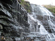
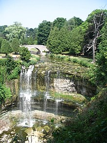
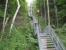
The Hamilton Conservation Authority owns, leases or manages about 4,500 hectares (11,100 acres) of land with the City operating 1,077 hectares (2,661 acres) of parkland at 310 locations.[9][10] Many of the parks are located along the Niagara Escarpment, which runs from Tobermory at the tip of the Bruce Peninsula in the north, to Queenston at the Niagara River in the south, and provides views of the cities and towns at the western end of Lake Ontario. The hiking path Bruce Trail runs the length of the escarpment.[11]Hamilton is home to more than 100 waterfalls and cascades, most of which are on or near the Bruce Trail as it winds through the Niagara Escarpment.[12]
Bay/Harbour
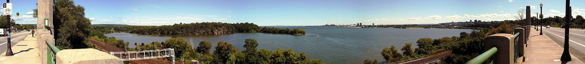
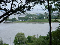
Panoramic view of Hamilton Harbour from T.B. McQuesten High Level Bridge on York Boulevard, near Harvey Park.
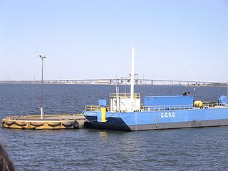
Burlington Bay is a natural harbour with a large sandbar called the Beachstrip. The first aboriginals to settle in the Hamilton area called this bay Macassa, meaning "beautiful waters".[13] This sandbar was deposited during a period of higher lake levels during the last ice age, and extends southeast through the central lower city to the escarpment. Hamilton's deep sea port is accessed by ship canal through the beach strip into the harbour and is traversed by two bridges, the QEW's Burlington Bay - James N. Allan Skyway and the lower Canal Lift Bridge. Hamilton Harbour ranks one of Canada's largest seaports. The Hamilton Port Authority manages the heavily industrial harbour.[14]
Volume of water: 2.8 x 10 to 8th cubic feet (7.9 million m³) of water
Reduction in surface area from 1926 to 1982: 22%
Navigational season is from April through to mid December
City and suburbs
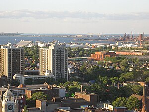
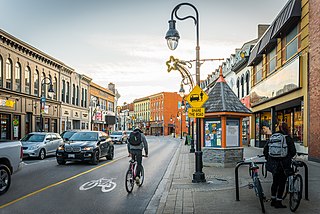
Downtown began and remains around Gore Park and the intersection of King and James Streets. Central Hamilton extends from the base of the Mountain north to Barton Street, west to Chedoke Creek or Dundurn Street, and east to approximately Wentworth Street or Sherman Avenues. West Hamilton or the west end begins at Dundurn Street or Chedoke Creek. East Hamilton or the east end begins at approximately Ottawa Street or Kenilworth Avenue. North Hamilton or the north end begins at Barton Street or the Canadian National Railways (CN) tracks.
As city limits expanded to include the Mountain, the retronym for the city below the Escarpment became the Lower City (now often just referred to as downtown). The east/west divide line for the mountain is Upper James Street, and the east/west divide line for downtown is James Street. The south Mountain begins at approximately Limeridge Road or the Lincoln M. Alexander Expressway.
Hamilton, like many cities, is broken up into several areas, well known to the local residents. Some 'sections' of the city include: Ainslie Wood, The North End, Downtown, the East and West End, Westdale (the area where McMaster University is located, and therefore has a high percentage of students), Beasley, Crown Point, McQuesten, Stinson, Locke, Dundas, Ancaster (including Meadowlands, which is often seen as separate from Ancaster), the West, Central, and East Mountain, Stoney Creek and Stoney Creek Mountain. These areas are all unique, and the people, economy and cultures vary a great deal across the city.
The Niagara Escarpment in Hamilton is a vertical wall of limestone, sandstone and shale that runs through southern Ontario from western New York to the Wisconsin/Illinois border. The Hamilton portion, in many places 100 m (330') tall, is commonly referred to as "the Mountain" by locals. On average the Hamilton Mountain is 4–5km inland from the Lake Ontario shoreline and at its edge affords views of the city and harbour.[citation needed] The number of waterfalls within the City of Hamilton limits have recently[when?] inspired local tourism interests to market Hamilton as the "City of Waterfalls". More than 100 waterfalls and cascades flow over Hamilton Mountain within city limits,[16] including Stoney Creek, Red Hill Creek, Grindstone Creek, Spencer Gorge Waterfall and Chedoke Creek, which flows into the Hamilton Harbour and most of which can be found along the Bruce Trail.
During the Ordovician period, the Michigan Basin was under a shallow, tropical sea. Muds and sands were deposited from erosion of the Taconic Mountains to the south, creating the base shale and sandstone units of the Niagara Escarpment. Later, during Silurian period, the Taconic Mountains stopped uplifting, erosion slowed, and calcium carbonate sediments formed, creating the upper limestone and dolomite beds of the Escarpment. Fossils such as sponges, crinoids, brachiopods and rugose corals, indicating warm tropical waters, can be found in the Escarpment. There were fish, a species of shark, but none of their remains have been found in this district. The limestone layer of rock found here becomes thicker as one goes northward. At Manitoulin Island it is 200 feet (61m) thick, suggesting that the water must have been shallower in Hamilton.[2]
The shale layer underlying the limestone in the Escarpment allows for its perpendicularity; the soft shale wears away more rapidly than limestone and thus the top layer always stays out farther than the part below.[2]
The Dundas Valley is a glacial re-entrant valley, formed by several advances and retreats of an ice lobe. A thick layer of glacial and post-glacial deposits is found on the valley floor. Glacial geomorphological features such as kame moraines and kettles are present.[17]
During the last glacial retreat, a large lake called Lake Iroquois was in the approximate location of Lake Ontario. It was likely formed as a result of ice damming in the St. Lawrence River. The lake laid down glaciolacustrine sediments such as sand and clay in the lower city and created the beach bar between Cootes Paradise and Hamilton Harbour.[2]
Soil in Hamilton is predominately derived from glacial drift (glaciolacustrine sediments in the lower city; glacial tills in the upper city) and from limestone and shale erosion.[2]
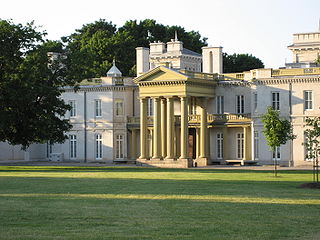
Acting on provisions of the Public Parks Act of 1883, the voters of Hamilton, on 8 January 1900, endorsed a by-law establishing the Board of Parks Management, an independent body whose members were appointed for three-year terms. The need for the new organization was obvious as when it began there were only three formal parklands at the disposal of residents in the community; the Gore, acquired by the city in 1852, Dundurn, which was appropriated by the City in 1899, and Victoria Park on King Street West, which by this time had lost an imposing landmark, the Crystal Palace. From then on other parks were opened in town because of the efforts of the group. These include, (in chronological order); Mountain Drive (1905), Beulah (1908), Stewart & LaSalle (1912), Delta (1914), Gage (1917), whose Rose Garden attracted tourists province-wide, Scott (1919), which eventually became the future home of Civic Stadium (Ivor Wynne Stadium), Parkdale & Chedoke (1925), Ainslie Woods (1927), King's Forest, Mahoney, and Donohue (1929), Bruce (1936), and Mount Hamilton (1939). 3,000 acres (12km2) altogether were acquired and developed by the Board in the span of a half a century.[18]
The City's Parks Board drew up plans in 1927 for the construction of a full-scale botanical gardens. By 1930 work had started on the project which converted a stone quarry into a horticultural showcase, known as the Royal Botanical Gardens. A decade later a bill was introduced in the Provincial Legislature calling for an even more ambitious project which when completed would become the "Mecca of flower lovers from all parts of North America" its supporters claimed. The sponsor of the legislation was the Minister of Highways in the Provincial Government, and native Hamiltonian, T.B. McQuesten.[18]
The climate of Hamilton is humid continental (Dfa type) and relatively mild compared with most Canadian cities. The average January temperature is −5°C (23.0°F) downtown, but many days rise just above freezing often making for slushy conditions during snowfalls.[19] Winter snowfall averages 126 centimetres (50in) with great year-to-year variation.[19] The average July temperature is 22°C (71.6°F) and humidity is usually high during the peak of summer.[19] Daytime highs in the 30s with humidex making it feel above 40°C are quite common anytime from May through early October.
The climate of the lower city is in general much more sheltered and milder than on top of the Mountain, which has a shorter growing season and in winter is prone to more wind whipped lake effect snows. Generally the lower city receives less snow than the upper city. The escarpment also greatly affects summer weather; temperature inversions can make the downtown many degrees warmer, particularly at night, and often an inversion will combine with the physical barrier of the escarpment to trap smog in the downtown area, sometimes reducing downtown visibility to less than 2km.
Summer rains can be heavy but in general severe weather is rare. One notable exception was a late season tornado that occurred November 9, 2005 damaging hundreds of houses and lifted off Lawfield Middle School's gymnasium roof on the Hamilton Mountain, injuring two students and leaving the school structurally unsound. Environment Canada confirmed an F1 tornado struck the area; this was one of the latest dates in any year that a confirmed tornado touched down in Canada.
Notes
↑ Based on station coordinates provided by Environment and Climate Change Canada, climate data for was recorded near downtown Hamilton from January 1866 to August 1958, and April 1950 to present at the Royal Botanical Gardens.
Related Research Articles
Hamilton is a port city in the Canadian province of Ontario. Hamilton has a population of 569,353 (2021), and its census metropolitan area, which encompasses Burlington and Grimsby, has a population of 785,184. The city is situated approximately 45 kilometres (28 mi) southwest of Toronto in the Greater Toronto and Hamilton Area (GTHA).
The Niagara Escarpment is a long escarpment, or cuesta, in Canada and the United States that starts from the south shore of Lake Ontario westward, circumscribes the top of the Great Lakes Basin running from New York through Ontario, Michigan, and Wisconsin. The escarpment is the cliff over which the Niagara River plunges at Niagara Falls, for which it is named.
Burlington is a city and lower-tier municipality in Halton Region at the west end of Lake Ontario in Ontario, Canada. Located approximately halfway between Toronto and Niagara Falls, it is part of the Greater Toronto Area and the Hamilton census metropolitan area.
St. Catharines is the most populous city in Canada's Niagara Region, the eighth largest urban area in the province of Ontario. As of 2017, St. Catharines has an area of 96.13 square kilometres (37.12 sq mi) and 140,370 residents. It lies in Southern Ontario, 51 kilometres (32 mi) south of Toronto across Lake Ontario, and is 19 kilometres (12 mi) inland from the international boundary with the United States along the Niagara River. It is the northern entrance of the Welland Canal. Residents of St. Catharines are known as St. Catharinites. St. Catharines carries the official nickname "The Garden City" due to its 1,000 acres (4 km2) of parks, gardens, and trails.
The Queen Elizabeth Way (QEW) is a 400-series highway in the Canadian province of Ontario linking Toronto with the Niagara Peninsula and Buffalo, New York. The highway begins at the Canada–United States border on the Peace Bridge in Fort Erie and travels 139.1 kilometres (86.4 mi) around the western end of Lake Ontario, ending at Highway 427 as the physical highway continues as the Gardiner Expressway into downtown Toronto. The QEW is one of Ontario's busiest highways, with an average of close to 250,000 vehicles per day on some sections.
The Genesee River is a tributary of Lake Ontario flowing northward through the Twin Tiers of Pennsylvania and New York in the United States. The river contains several waterfalls in New York at Letchworth State Park and Rochester.
Hamilton East was a federal electoral district in Ontario, Canada. It was represented in the House of Commons of Canada from 1904 to 2004. It consisted of the eastern part of the city of Hamilton, Ontario. It is considered a working class district.
The Royal Botanical Gardens (RBG) is a heritage-listed botanical garden located in the cities of Burlington and Hamilton in Ontario, Canada. It covers extensive environmentally protected areas, historic sites, and culturally relevant gardens from Burlington to Hamilton. It is one of the major tourist attractions between Niagara Falls and Toronto, as well as being a significant local and regional horticultural, education, conservation, and scientific resource.
Hamilton Harbour lies on the western tip of Lake Ontario, bounded on the northwest by the City of Burlington, on the south by the City of Hamilton, and on the east by Hamilton Beach and Burlington Beach. It is joined to Cootes Paradise by a narrow channel formerly excavated for the Desjardins Canal. Within Hamilton itself, it is referred to as "Hamilton Harbour", "The Harbour" and "The Bay". The bay is naturally separated from Lake Ontario by a sand bar. The opening in the north end was filled in and channel cut in the middle for ships to pass. The Port of Hamilton is on the Hamilton side of the harbour.
Thomas Baker McQuesten was a Canadian politician in Ontario, Canada. He was a Liberal member of the Legislative Assembly of Ontario from 1934 to 1943 who represented the riding of Hamilton—Wentworth. He served as a cabinet minister in the governments of Mitchell Hepburn and Gordon Conant.
King's Highway 20, commonly referred to as Highway 20, is a provincially maintained highway in the Canadian province of Ontario. Presently, it is a short 1.9 km (1.2 mi) stub between Highway 58 and Niagara Regional Road 70 in the City of Thorold, but until 1997 it connected Hamilton to Niagara Falls, serving several towns atop the Niagara Escarpment en route.
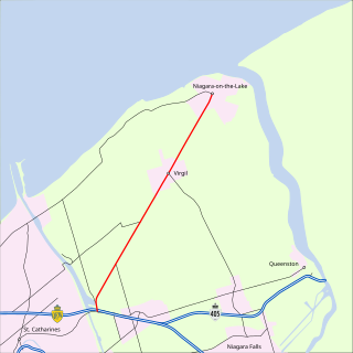
King's Highway 55, commonly referred to as Highway 55 and historically as the Niagara Stone Road and Black Swamp Road, was a provincially maintained highway in the Canadian province of Ontario, which connected the Queen Elizabeth Way (QEW) with Niagara-on-the-Lake, following Niagara Stone Road. The route divided a swath of wineries at the foot of the Niagara Escarpment, passing at an oblique angle to the concession road grid.
Dundurn Street is a Lower City arterial road in Hamilton, Ontario, Canada. It is a two-way street that starts off at Mountain Face Park, Niagara Escarpment in front of the Bruce Trail as a collector road, right behind Hillcrest Avenue and then turns into a four lane thoroughfare from Aberdeen Avenue northward to York Boulevard where it ends in front of Dundurn Park.
Centennial Parkway is an arterial road in southeastern Hamilton, Ontario, Canada. It is best known as the western terminus of the former King's Highway 20, now maintained by the City of Hamilton. It starts off as Upper Centennial Parkway, a mountain-access road in the City right before the Canadian Pacific Railway line at the backend of Battlefield Park, and is a two-way street throughout that extends north over the Queen Elizabeth Way and ends at Beach Boulevard/Van Wagners Beach Road in front of Confederation Park.
Aberdeen Avenue is a Lower City minor arterial road in Hamilton, Ontario, Canada. It starts off just west of Longwood Road South and east of Highway 403 as a two-way thoroughfare up to Queen Street South, where it then switches over to a one-way collector road (eastbound) to Bay Street South and then to another two-way section from Bay Street to James Mountain Road, a mountain-access road in the city near the base of the Niagara Escarpment (mountain).
The Chedoke Creek is an urban creek that runs through the west end of Hamilton, Ontario. It crosses the Bruce Trail and the Radial Trail.
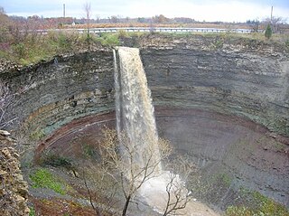
Devil's Punch Bowl is a 37-metre ribbon waterfall on the Niagara Escarpment, in the Stoney Creek community of Hamilton, Ontario, Canada. It is in the Devil's Punchbowl Conservation Area maintained by the Hamilton Conservation Authority, and features an escarpment access trail with connections to a section of the Bruce Trail. Stoney Creek's Dofasco 2000 Trail is nearby. The Punch Bowl is also known as Horseshoe Falls for the distinctive shape of the cliff-face, which somewhat resembles its much larger cousin in Niagara Falls.
Hamilton East—Stoney Creek is a provincial electoral district in Ontario, Canada, that has been represented in the Legislative Assembly of Ontario since the 2007 provincial election.
Lakeshore Road is a historic roadway in the Canadian province of Ontario, running through the city of Burlington and the town of Oakville in Halton Region, as well as the city of Mississauga in Peel Region. As its name implies, the road closely follows the shoreline of Lake Ontario, although the lake itself is not visible from the road in most areas. Lakeshore Road was once a key section of the historic Highway 2, which traversed the province, but has since been downloaded to local municipalities. Despite this historical role as a major route, however, most of the road is a lower-capacity picturesque residential and historic commercial street with only two through lanes until it becomes a four-lane, higher-volume artery after it enters Mississauga and jogs to the north.
References
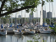
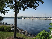
Hamilton Bay with Skyway in backgroundHamilton's Marina with Dofasco in background
This page is based on this Wikipedia article Text is available under the CC BY-SA 4.0 license; additional terms may apply. Images, videos and audio are available under their respective licenses.