Locke Street (Hamilton, Ontario)

Last updated

Locke Street South LockeStreetHamilton.JPG
Locke Street South

Locke Street is a Lower City collector road in Hamilton, Ontario, Canada. It starts off at Aberdeen Avenue as a two-way street going through the Locke Street shopping district up to Main Street where it then becomes a one-way street until it crosses King Street and becomes two-way again going north past Victoria Park and ends just past Barton Street West on Tecumseh Street, a road that winds West and leads to the back-end of Dundurn Park.

Contents

History

Locke Street South, walking tour LockeStreetHamiltonB.JPG
Locke Street South, walking tour
Locke Street South, walking tour LockeStreetHamiltonE.JPG
Locke Street South, walking tour
Locke Street South, walking tour LockeStreetHamiltonF.JPG
Locke Street South, walking tour
LockeStreetHamiltonK.JPG
LockeStreetHamiltonN.JPG

The origins of Locke Street's name can be traced back as early as 1840, when it was spelled "Lock"; by 1870 the spelling was standardized to "Locke." North of King Street West was known as Railway Street because it ran to the Great Western Railway yards. Locke Street North is mostly residential and in the 1800s most of the homes there belonged to the railway workers and their families. [1]

Locke Street is a "street of churches" and a "hub for antique shops." The early churches were founded as follows:

Prior to 1853, just south of Herkimer Street on Locke was the site of the Beasley Racetrack. The racetrack was named after its owner and operator Richard Beasley (1761–1842), who was a soldier, political figure, farmer and businessman. [3] It was a popular spot featuring both trotting and steeplechase racing. [2]

Just off Locke near Charlton, the Hamilton Amateur Athletic Association Grounds is a park that was home to the Hamilton Tiger-Cats from 1872–1949. Today it is also the site of the Hamilton Tennis Club. [4] Before it was used for football, the park was the site of a cricket club, and in 1860 a racquet club was established near the present site of the Hamilton Tennis Club. In 1870, Locke South was described as a "sparsely populated mud track."[ citation needed ]

Despite rapid expansion of the city[ citation needed ], Locke Street South was still an isolated area. On the other hand, Locke Street North continued[ citation needed ] with its residential growth and the development of Victoria Park and the opening of the Crystal Palace. The Crystal Palace opened up at Victoria Park on 20 September 1860 by Edward, Prince of Wales (who later became King Edward VII). It was home to the area's largest fall fair (agriculture exhibition) for many years. The Hamilton Herald reported on 22 September 1890 that "The Carnival of Venice, The Paris Exposition or the World's Fair in Chicago will be nowhere tomorrow when the great Central Fair is opened at the Crystal Palace Grounds in this city." The structure was demolished in 1891. [3] [5]

By 1885, Locke Street South began to grow, after a brick sewer was constructed and gas lines were laid. In 1889, Wesley Vollick, a cabinet maker, built a small brick cottage that in 1924 became the Locke Street Library. [2]

In 1890, The Hamilton Street Railway (HSR) built its western terminus on the northeast corner of Locke & Herkimer Streets. A two-storey tram building and horse barn which could accommodate up to 42 horses and 12 tram cars. As well, the Hamilton-Dundas Electric Railway line, nicknamed the "Dundas Dummy", travelled along Aberdeen Avenue and crossed over Locke Street South. [2]

In 2000, Locke Street South celebrated its 150th anniversary.

In March 2018 a small group of people vandalized businesses on Locke Street in response to gentrification in Hamilton. [6]

Festivals

Locke Street has festivals held throughout the year. One is called Spring Blooms on Locke, an annual festival that marks the end of winter and is also a fundraiser for sick children. The Locke Street Festival where each September the street is closed off for a day with live entertainment, street vendors, and food. [7] The Christmas Open House celebrates the holidays with businesses open late, food, drink, and carollers each November. [8]

Major intersections

North to south:

Related Research Articles

Bay Street (Hamilton, Ontario)

Bay Street is a Lower City arterial road in Hamilton, Ontario, Canada. It starts at Inglewood Drive, just South of Aberdeen Avenue, as a collector road with only two lanes, then eventually becomes a six lane thoroughfare at its peak. Bay Street also passes through Downtown Hamilton, where many high-rise buildings are found. Bay Street is a one-way street from Aberdeen Avenue to Cannon Street West. Bay Street continues as an arterial route to Strachan Street, where it is downgraded to a neighbourhood collector and eventually ends at a curb at Pier 4 Park at Burlington Street in the city's North End.
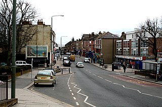
Hughson Street

Hughson Street is a Lower City collector road in Hamilton, Ontario, Canada. It starts at Charlton Avenue East at St. Joseph's hospital and runs north to Haymarket Street in the downtown where it's cut off by the Hamilton GO Transit station. Up to this point it is a two-way street. It then starts up again north of the station on Hunter Street East, where it then becomes a one-way street going north just past Barton Street East to Murray Street where it's cut off again by a parking lot for LIUNA Station. It then starts up again one block north past the CN railway tracks on Strachan Street and from this point onwards becomes a two-way street again that extends to the city's North End to the waterfront on Guise Street West, the site of the Canada Marine Discovery Centre and Pier 9.

John Street (Hamilton, Ontario)

John Street is a Lower City arterial road in Hamilton, Ontario, Canada. Originally it was known as Mountain Road or Ancaster Road. It starts off at the base of Arkledun Avenue, a Mountain-access road in the city, just east of St. Joseph's Hospital, where it is a one-way street going north and tunnels underneath the Hunter Street Railway bridge and continues onward to the city's North End at the waterfront, where it ends at Guise Street East, the site of Pier 9.

Hess Street (Hamilton, Ontario)

Hess Street is a Lower City collector road in Hamilton, Ontario, Canada. It starts off at the base of the Niagara Escarpment right before Aberdeen Avenue, and is a one-way street going north past the Durand and Central neighbourhoods. Between Main and King Street West is Hess Village, a cobblestone pedestrian zone of nightclubs, bars, and historic buildings. Hess Street then continues onwards to the waterfront where it ends at Stuart Street, right in front of the Canadian National Railway Yard.

Wellington Street (Hamilton, Ontario)

Wellington Street is a Lower City arterial road in Hamilton, Ontario, Canada. It starts off at Charlton Avenue East as a two-way street for only one block where it's then blocked off by the Corktown Park and a couple of Canadian National Railway lines that cut through it. It then starts up again north of the park on Young Street and is a one-way street the rest of the way (Southbound). It ends in the North End of the City on Burlington Street East, in front of the Lakeport Brewing Company and the Administration offices of the Hamilton Port Authority.

Queen Street (Hamilton, Ontario)

Queen Street is a Lower City arterial road in Hamilton, Ontario, Canada. It starts off at Beckett Drive, a mountain-access road in the city and is a two-way street up to Herkimer Street and a one-way street (Southbound) the rest of the way north up to the Canadian National Railway Yard where the road turns right, merging with Stuart Street which travels in a west–east direction.

Dundurn Street (Hamilton, Ontario)

Dundurn Street is a Lower City arterial road in Hamilton, Ontario, Canada. It is a two-way street that starts off at Mountain Face Park, Niagara Escarpment in front of the Bruce Trail as a collector road, right behind Hillcrest Avenue and then turns into a four lane thoroughfare from Aberdeen Avenue northward to York Boulevard where it ends in front of Dundurn Park.

Catharine Street (Hamilton, Ontario)

Catharine Street is a Lower City collector road in Hamilton, Ontario, Canada. It starts off at Charlton Avenue East at Woolverton Park in the Corktown neighbourhood as a one-way street (southbound), tunnels underneath the Hunter Street Railway bridge and stretches up to Barton Street East where it then turns two-way and cutoff by the CN Railway lines that cut through Strachan Street Park one block north past Barton. Catharine Street then resumes again on Strachan Street East, north of the Park again as a two-way road for 3 blocks and interrupted again at Picton Street East, the site of St. Lawrence Elementary School and resumes again north of this property on Macauley Street East, again as a two-way street for another 3 blocks where it's interrupted for a third time at Brock Street, the site of Eastwood Park and Eastwood Arena. Catherine Street resumes again north of Eastwood Park on Guise Street East and ends at the city's North End waterfront, the site of a Royal Canadian Navy base and Pier 9.

Ferguson Avenue (Hamilton, Ontario)

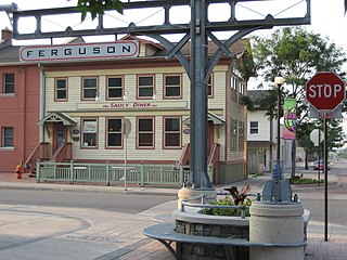
Ferguson Avenue is a Lower City collector road in Hamilton, Ontario, Canada. It is a two-way street throughout that starts off at the base of the Mountain on Foster Street. It's interrupted 3 blocks north at Corktown Park where Canadian Pacific Railway lines passes through it. Ferguson Avenue resumes again north of the Park right before Hunter Street East, extending northward past Barton Street East through the city's North End industrial neighbourhood where it ends on Dock Service Road, the site of a Royal Canadian Navy base and Pier 10.

Barton Street (Hamilton, Ontario)

Barton Street is an arterial road in the Lower City of Hamilton, Ontario, Canada. It's also the longest street (21.0 km) in the city. It starts at the north end of downtown at Locke Street North and is a two-way street that stretches eastward through a number of different and varied communities in the city and ends in Winona at Fifty Road just west of the Hamilton/Niagara regional boundary. The street is divided in East and West portions, divided by James Street. However, the East designation does not continue through the Stoney Creek district, which was a separate municipality prior to amalgamation in 2001, and the designation as well as the address numbering system were not restructured upon amalgamation, and numbers reset at the former city limits at Centennial Parkway.

Cannon Street (Hamilton, Ontario)

Cannon Street, is a Lower City collector road in Hamilton, Ontario, Canada. It starts off at Queen Street North as a one-way street (Westbound) up to Sherman Avenue North where it then switches over to a two-way street the rest of the way Eastward and ends just past Kenilworth Avenue North on Barons Avenue and merges with Britannia Avenue, a street that runs parallel with Cannon Street from Ottawa Street North to Barons Avenue.

Wilson Street (Hamilton, Ontario)

Wilson Street is a Lower City collector road in Hamilton, Ontario, Canada. It starts off at James Street North and works its way East and ends at Sherman Avenue North. The section between James Street and Ferguson Avenue was a one-way road, but was converted to a two-way street at 10 am on December 10, 2010.

King Street (Hamilton, Ontario)

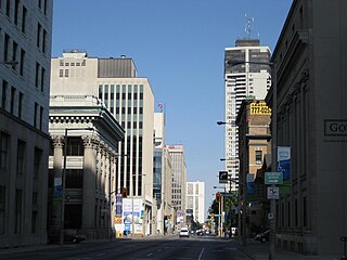
King Street is a Lower City arterial road in Hamilton, Ontario, Canada, also known as Highway 8. The western-end starts off in front of the McMaster University Medical Centre as a two-way street and passes through Westdale. At Paradise Road, King Street switches over to a one-way street (westbound) right through the city's core up to "the Delta", a spot in town where King and Main streets intersect. From the Delta onwards, King Street then switches over to become a two-way street again and ends at Highway 8 in Stoney Creek.

Main Street (Hamilton, Ontario)

Main Street is a street in Hamilton, Ontario, Canada.

Jackson Street (Hamilton, Ontario)

Jackson Street, is a Lower City collector road in Hamilton, Ontario, Canada. It starts off West of Locke Street South at Jackson Playground as a one-way street (Westbound) up to Queen Street South where it then switches over to a two-way street and is interrupted at Bay Street South the site of the Hamilton City Hall and the Canadian Football Hall of Fame (museum), resumes again East of the property on MacNab Street South and then ends at Wellington Street South.

Hunter Street (Hamilton, Ontario)

Hunter Street is a Lower City collector road in Hamilton, Ontario, Canada. It is a one-way street (Westbound) that starts West of Locke Street at Hill Street Park and ends two blocks East of Victoria Avenue at Emerald Street.

Beasley is the name of a neighbourhood in the Lower City area of Hamilton, Ontario, Canada. The Beasley neighbourhood is bounded in the north by the Canadian National Railway tracks just north of Barton Street, James Street (west), Main Street (south) and Wellington Street (east).

Charlton Avenue (Hamilton, Ontario)

Charlton Avenue, is a Lower City collector road in Hamilton, Ontario, Canada. This collector road starts off just west of Dundurn Street as a one-way street (Westbound) up to James Street South where it then switches over to a two-way street the rest of the way eastward and ends at Wentworth Street South right in front of Mountain Face Park and the Escarpment Rail Trail.

Aberdeen Avenue

Aberdeen Avenue is a Lower City minor arterial road in Hamilton, Ontario, Canada. It starts off just west of Longwood Road South and east of Highway 403 as a two-way thoroughfare up to Queen Street South, where it then switches over to a one-way collector road (eastbound) to Bay Street South and then to another two-way section from Bay Street to James Mountain Road, a mountain-access road in the city near the base of the Niagara Escarpment (mountain).

References

  1. Houghton, Margaret (2002). Hamilton Street Names: An Illustrated Guide. James Lorimer & Co. Ltd. ISBN   1-55028-773-7.
  2. 1 2 3 4 Manson, Ann & Bill (1999). Up and Down Locke Street South. North Shore Publishing. ISBN   1-896899-08-0.
  3. 1 2 Bailey, Thomas Melville (1981). Dictionary of Hamilton Biography (Vol I, 1791-1875). W.L. Griffin Ltd.
  4. "A.A.A. Grounds: Canadian Football Timelines; Canadian Football web site". Archived from the original on 28 February 2007. Retrieved 24 April 2007.
  5. Henley, Brian (1993). Hamilton our Lives and Times. The Hamilton Spectator. ISBN   0-9697255-0-7.
  6. Wilson, Codi (4 March 2018). "Shops in Hamilton damaged after masked group went on vandalism spree: police". CP24. Retrieved 1 August 2019.
  7. "Locke Street Festival: Official site" . Retrieved 24 July 2008.
  8. "Locke Street Shopping District" . Retrieved 5 April 2007.

Coordinates: 43°15′52″N79°52′55″W / 43.2645°N 79.8820°W / 43.2645; -79.8820