Gage Avenue (Hamilton, Ontario)

Last updated
Gage Park fountain Gage Park Fountain.jpg
Gage Park fountain

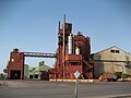
Gage Avenue is a Lower City arterial road in Hamilton, Ontario, Canada. It starts off at Lawrence Road at the base of the Niagara Escarpment (mountain) at the south end of Gage Park. It is a two-way arterial road that extends north through the city's North End industrial neighbourhood and ends at Industrial Drive.

Contents

History

Gage Park fountain and watercourse Gage Park Fountain Watercourse.jpg
Gage Park fountain and watercourse
Gage Park, George R. Robinson Bandshell GageParkBandshellHamilton.JPG
Gage Park, George R. Robinson Bandshell

Gage Avenue and Upper Gage Avenue are named after the park of the same name whose western border is bounded by Gage Avenue. The park was on lands sold by Robert Russel Gage, a descendant of William Gage and named in honour of the Gage families that descended from James Gage, a lumber merchant and his uncle William Gage, a farmer. Together James and William had farms that were the site of the Battle of Stoney Creek during the War of 1812. The wounded were treated inside their homes and they were both awarded compensation for it by the government. [1] Originally Gage Avenue was called Trolley Street. [2]

Tim Horton's Field (2 blocks West of Gage Avenue) is the home of the Hamilton Tiger-Cats of the Canadian Football League. The stadium was originally known as Civic Stadium and was constructed in 1930 to host the 1930 British Empire Games; Canada's first major international athletic event, held in Hamilton from August 16 to 23, 1930. The stadium is now surrounded by residential housing in Hamilton's east side. [3] The CFL's annual Eastern Division Labour Day Classic pits the Hamilton Tiger-Cats against perennial rivals the Toronto Argonauts. This particular weekend, typically the tenth or eleventh week in the season, is known for its fixtures that do not change from year to year. Oddly, for many years before his death, Harold Ballard owned both the Hamilton Tiger-Cats and the Toronto Maple Leafs, the National Hockey League (NHL) franchise in rival city Toronto. [4] The Hamilton A.A.A. Grounds, (Hamilton Amateur Athletic Association Grounds), is a park that was home to the Hamilton Tiger-Cats from 1872 to 1949. That Park is still there today and can be found at Queen Street South, right before Charlton Avenue West. [5]

Festivals

Hamilton, Ontario has hosted several cultural and craft fairs since the 1960s, notably Festival of Friends, which made it a major tourist destination. The Festival of Friends, founded in 1975, is the largest annual free music event in Canada. Burton Cummings, Lighthouse, Finger Eleven, and Bruce Cockburn have been among the main stage headliners at the George R. Robinson Bandshell at Gage Park. [6]

Landmarks

Ivor Wynne Stadium IvorWynneStadium Hamilton.jpg
Ivor Wynne Stadium

Note: Listing of Landmarks from North to South.

Communities

Neighbourhood snapshot, Gage Avenue South GageSouthNeighbourhoodHamilton.JPG
Neighbourhood snapshot, Gage Avenue South
Ukrainian Orthodox Cathedral of St. Vladimir UkrainianOrthodoxHamilton.JPG
Ukrainian Orthodox Cathedral of St. Vladimir

Note: Listing of neighbourhoods from North to South [7]

Images

See also

Related Research Articles

<span class="mw-page-title-main">Hamilton Tiger-Cats</span> Canadian Football League team

The Hamilton Tiger-Cats are a professional Canadian football team based in Hamilton, Ontario, Canada. They are currently members of the East Division of the Canadian Football League (CFL). The Tiger-Cats play their home games at Tim Hortons Field.

<span class="mw-page-title-main">Ivor Wynne Stadium</span> Demolished Canadian football stadium in Hamilton, Ontario

Ivor Wynne Stadium was a Canadian football stadium located at the corner of Balsam and Beechwood avenues, two blocks west of Gage Avenue North in Hamilton, Ontario, Canada. The stadium was the home of the Hamilton Tiger-Cats of the CFL from 1950 until it closed on October 27, 2012. The club's previous home was the Hamilton Amateur Athletic Association Grounds. The stadium was replaced by Tim Hortons Field, with a fixed capacity of 24,000, on the same property.

<span class="mw-page-title-main">Dufferin Street</span> Roadway in Ontario, Canada

Dufferin Street is a major north–south street in Toronto, Vaughan and King, Ontario, Canada. It is a concession road, two concessions (4 km) west of Yonge Street. The street starts at Exhibition Place, continues north to Toronto's northern boundary at Steeles Avenue with some discontinuities and continues into Vaughan, where it is designated York Regional Road 53. The street is named for Frederick Hamilton-Temple-Blackwood, 1st Marquess of Dufferin and Ava, who served as Governor General of Canada from 1872 to 1878. Prior to 1878 the street was labelled as Western City Limits or Sideline Road south off Bloor. In 2003 and 2007, it was voted as one of "Ontario's Worst 20 Roads" in the Ontario's Worst Roads poll organized by the Canadian Automobile Association.

<span class="mw-page-title-main">Labour Day Classic</span> Annual CFL rivalry games

The Labour Day Classic is a week of the Canadian Football League (CFL) schedule played over the Labour Day weekend. Labour Day weekend, roughly 12 or 13 weeks into the CFL season, is known for its matchups that do not change from year to year, unlike other "rivalry" weeks of the CFL schedule. Labour Day weekend is also one of typically two weeks in the CFL schedule that the league plays on a Monday. Multinational Balkrishna Industries' OK Tire brand is the presenting sponsor of the event as of 2022.

<span class="mw-page-title-main">Geography of Hamilton, Ontario</span>

Hamilton is located on the western end of the Niagara Peninsula and wraps around the westernmost part of the Lake Ontario. Most of the city including the downtown section lies along the south shore. Situated in the geographic centre of the Golden Horseshoe, it lies roughly midway between Toronto and Buffalo. The two major physical features are Hamilton Harbour marking the northern limit of the city and the Niagara Escarpment running through the middle of the city across its entire breadth, bisecting the city into 'upper' and 'lower' parts.

<span class="mw-page-title-main">John Street (Hamilton, Ontario)</span> Street in Hamilton, Ontario, Canada

John Street is a Lower City arterial road in Hamilton, Ontario, Canada. Originally it was known as Mountain Road or Ancaster Road. It starts off at the base of Arkledun Avenue, a Mountain-access road in the city, just east of St. Joseph's Hospital, where it is a one-way street going north and tunnels underneath the Hunter Street Railway bridge and continues onward to the city's North End at the waterfront, where it ends at Guise Street East, the site of Pier 9.

<span class="mw-page-title-main">James Street (Hamilton, Ontario)</span>

James Street is a Lower City arterial road in Hamilton, Ontario, Canada. It starts off at the base of the Niagara Escarpment from James Mountain Road, a mountain-access road in the city. It was one of many arterials in the central business district converted to one-way operation in 1956 when the city retained Wilbur Smith and Associates to develop a Traffic and Transportation Plan. Parts of it were restored to two-way operation in 2002. It extends north to the city's waterfront at the North End where it ends at Guise Street West right in front of the Harbour West Marina Complex and the Royal Hamilton Yacht Club.

<span class="mw-page-title-main">Wellington Street (Hamilton, Ontario)</span>

Wellington Street is a Lower City arterial road in Hamilton, Ontario, Canada. It starts off at Charlton Avenue East as a two-way street for only one block where it's then blocked off by the Corktown Park and a couple of Canadian National Railway lines that cut through it. It then starts up again north of the park on Young Street and is a one-way street the rest of the way (Southbound). It ends in the North End of the City on Burlington Street East, in front of the Lakeport Brewing Company and the Administration offices of the Hamilton Port Authority.

<span class="mw-page-title-main">Queen Street, Hamilton, Ontario</span> Lower City arterial road in Hamilton, Ontario, Canada

Queen Street is a Lower City arterial road in Hamilton, Ontario, Canada. It starts off at Beckett Drive, a mountain-access road in the city and is a two-way street up to King Street West and a one-way street (southbound) the rest of the way north up to the Canadian National Railway Yard, where the road turns right, merging with Stuart Street which travels in a west–east direction.

<span class="mw-page-title-main">Dundurn Street (Hamilton, Ontario)</span> Lower City arterial road in Hamilton, Ontario, Canada

Dundurn Street is a Lower City arterial road in Hamilton, Ontario, Canada. It is a two-way street that starts off at Mountain Face Park, Niagara Escarpment in front of the Bruce Trail as a collector road, right behind Hillcrest Avenue and then turns into a four lane thoroughfare from Aberdeen Avenue northward to York Boulevard where it ends in front of Dundurn Park.

<span class="mw-page-title-main">Ferguson Avenue (Hamilton, Ontario)</span>

Ferguson Avenue is a Lower City collector road in Hamilton, Ontario, Canada. It is a two-way street throughout that starts off at the base of the Mountain on Foster Street. It's interrupted 3 blocks north at Corktown Park where Canadian Pacific Railway lines passes through it. Ferguson Avenue resumes again north of the Park right before Hunter Street East, extending northward past Barton Street East through the city's North End industrial neighbourhood where it ends on Dock Service Road, the site of a Royal Canadian Navy base and Pier 10.

<span class="mw-page-title-main">Wentworth Street</span> Lower City arterial road in Hamilton, Ontario, Canada

Wentworth Street is a Lower City arterial road in Hamilton, Ontario, Canada. It starts off at the base of the Niagara Escarpment (mountain) on Charlton Avenue East just south of the CP lines and runs right through the city's North End industrial neighbourhood and ends north of Burlington Street East at Pier 14, which one time was used by International Harvester (1902–1992).

<span class="mw-page-title-main">Sherman Avenue (Hamilton, Ontario)</span> Collector road in the lower portion of Hamilton, Ontario, Canada

Sherman Avenue is a collector road in the lower portion of Hamilton, Ontario, Canada. It begins at the Niagara Escarpment just south of Cumberland Avenue and is a one-way street bisecting the industrialized northern neighbourhoods of the city. It ends at Ship Street — the site of Steel Company of Canada (Stelco).

<span class="mw-page-title-main">Ottawa Street (Hamilton, Ontario)</span>

Ottawa Street is a Lower City arterial road in Hamilton, Ontario, Canada. It starts off at Lawrence Road at the base of the Niagara Escarpment (mountain) and is a two-way street throughout, cutting through the Delta and Crown Point neighbourhoods and the City's North End industrial neighbourhood. It ends at Industrial Drive, the site of the Dofasco steel company. This used to be one of the east ends' mountain access roads - it continued south over the train tracks at Lawrence Road and quickly turned right towards the brick manufacturing plant once known as Hamilton Brick. It took several turns before joining what is now the Kenilworth Access near the old water reservoir entrance. Its routing up the mountain is fairly consistent with the current Kenilworth Access with one exception - another hair-pin turn at the top; not the traffic circle that is present now. It was because of these hair-pin turns that the Hamilton Street Railway discontinued bus service on this road in 1944, and why the City planned a new Kenilworth Access to the east which opened in 1957.

<span class="mw-page-title-main">Kenilworth Avenue (Hamilton, Ontario)</span> Lower City arterial road in Hamilton, Ontario, Canada

Kenilworth Avenue is a Lower City arterial road in Hamilton, Ontario, Canada. It starts off at the Kenilworth Traffic Circle and Kenilworth Access, a mountain-access road at the base of the Niagara Escarpment (mountain) and is a two-way street throughout stretching northward through the city's North End industrial neighbourhood where it then flows underneath the Burlington Street bridge and right into Dofasco's Industrial Park.

<span class="mw-page-title-main">Centennial Parkway</span> Road in Hamilton, Ontario, Canada

Centennial Parkway is an arterial road in southeastern Hamilton, Ontario, Canada. It is best known as the western terminus of the former King's Highway 20, now maintained by the City of Hamilton. It starts off as Upper Centennial Parkway, a mountain-access road in the City right before the Canadian Pacific Railway line at the backend of Battlefield Park, and is a two-way street throughout that extends north over the Queen Elizabeth Way and ends at Beach Boulevard/Van Wagners Beach Road in front of Confederation Park.

<span class="mw-page-title-main">Cannon Street (Hamilton, Ontario)</span>

Cannon Street is a Lower City collector road in Hamilton, Ontario, Canada. It starts off at Queen Street North as a one-way street (Westbound) up to Sherman Avenue North where it then switches over to a two-way street the rest of the way Eastward and ends just past Kenilworth Avenue North on Barons Avenue and merges with Britannia Avenue, a street that runs parallel with Cannon Street from Ottawa Street North to Barons Avenue.

<span class="mw-page-title-main">Aberdeen Avenue</span> Lower City minor arterial road in Hamilton, Ontario, Canada

Aberdeen Avenue is a Lower City minor arterial road in Hamilton, Ontario, Canada. It starts off just west of Longwood Road South and east of Highway 403 as a two-way thoroughfare up to Queen Street South, where it then switches over to a one-way collector road (eastbound) to Bay Street South and then to another two-way section from Bay Street to James Mountain Road, a mountain-access road in the city near the base of the Niagara Escarpment (mountain).

<span class="mw-page-title-main">Concession Street (Hamilton, Ontario)</span> Road in Hamilton, Ontario, Canada

Concession Street is an Upper City (mountain) arterial road in Hamilton, Ontario, Canada. It starts at Belvidere Avenue, just west of Sam Lawrence Park, and extends eastward past Mountain Drive Park on Upper Gage Avenue and ends shortly thereafter at East 43rd Street.

<span class="mw-page-title-main">Upper James Street (Hamilton, Ontario)</span> Upper City (mountain) arterial road in Hamilton, Ontario, Canada

Upper James Street, is an Upper City (mountain) arterial road in Hamilton, Ontario, Canada. It starts at the Claremont Access, a mountain-access road in the north, and extends southward towards the John C. Munro Hamilton International Airport where it then changes its name to the Hamilton Port Dover Plank Road,. It is a two-way street throughout. As with most of the "Upper" streets, their addresses start at roughly the point where their lower counterpart finishes just below the Escarpment and were originally labelled without the "Upper" prefix.

References

  1. Bailey, Thomas Melville (1981). Dictionary of Hamilton Biography (Vol I, 1791-1875). W.L. Griffin Ltd.
  2. Manson, Bill (2003). Footsteps In Time: Exploring Hamilton's heritage neighbourhoods. North Shore Publishing Inc. ISBN   1-896899-22-6.
  3. Wilson, Paul. "Ivor Wynne Stadium" . Retrieved 2007-03-27.
  4. Beddoes, Dick (1989). Pal Hal: An uninhibited, no-holds-barred account of the life and times of Harold Ballard. Macmillan of Canada. ISBN   1-57243-390-6.
  5. "A.A.A. Grounds: Canadian Football Timelines; Canadian Football web site". Archived from the original on 2007-02-28. Retrieved 2007-03-28.
  6. "The Hamilton Memory Project;" (Press release). The Hamilton Spectator- Tourism Hamilton page MP54. 2006-06-10.
  7. "Hamilton Neighbourhood Boundaries, (map.hamilton.ca)" (PDF). Archived from the original (PDF) on 2007-09-27. Retrieved 2007-05-11.