John Street is a Lower City arterial road in Hamilton, Ontario, Canada. Originally it was known as Mountain Road or Ancaster Road. It starts off at the base of Arkledun Avenue, a Mountain-access road in the city, just east of St. Joseph's Hospital, where it is a one-way street going north and tunnels underneath the Hunter Street Railway bridge and continues onward to the city's North End at the waterfront, where it ends at Guise Street East, the site of Pier 9.
Talk of creating a townsite at what is now the intersection of John and Main streets arose as early as 1809, but the war delayed the scheme until 1816 when George Hamilton and Nathaniel Hughson successfully promoted Hamilton as the judicial centre for the counties of Halton and Wentworth (the Gore District).[1]
GO Transit station, view from John & Haymarket Streets
When the Town of Hamilton was incorporated in 1833, one of the first orders of business was to find a suitable place for the town board to meet. For the first few years they made do with meeting in local taverns such as Thomas Wilson's Inn on the corner of John and Jackson Streets.[2]
John Street is also one of the original native pathways in the area. In 1837, the police commission officially named it John Street - a name originally chosen by George Hamilton (City founder), apparently in honour of a family of early settlers.[3]
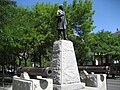
The John A. Macdonald Statue at Gore Park arrived in Hamilton from London, England on 30 October 1893. Official dedication of the statue took place 1 November 1893. Originally, the statue was located at the intersection of King and Hughson Streets and pointed West. Prime Minister Sir John Thompson was in attendance.[4]Alexander Aitchison, a local Hamilton Fire Chief, died of injuries he sustained from crashing into the base of the statue with his horse and buggy and because of it, the statue was then relocated to Gore Park near King and John Streets only this time the statue instead of pointing West, now points East.[5]
Ronnie Hawkins came to Canada in 1958. His first gig was at the Golden Rail in Hamilton near the corner of King and John Streets where he became an overnight success. It was a result of Hawkins success in Hamilton that he decided to move to Canada permanently. His career spans over five decades and 25 records. His hits include, "Forty Days", "Mary Lou", and "Hey Bo Diddley".[6]
Landmarks
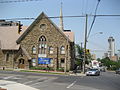
John Street South, walking tourJohn Street South, walking tourHamilton Central Fire Station
This page is based on this Wikipedia article Text is available under the CC BY-SA 4.0 license; additional terms may apply. Images, videos and audio are available under their respective licenses.