Niagara is a neighbourhood in Toronto, Ontario, Canada, located south of Queen Street West; it is usually bordered by Strachan Avenue to the west, Bathurst Street to the east, and the railway corridor to the south, and so named because Niagara Street runs through the centre of it. The eastern portion of this area was first planned as the New Town Extension when Toronto was incorporated as a city. The area was developed as a residential area for the workers of industries located along the CN and CP railway corridors. It remains a working-class neighbourhood that has seen the development of new condominium apartment buildings.

The Olympia Condos, a 33-storey condo building is the 4th tallest building in Hamilton, Ontario, Canada. Situated just east of John Street South on Charlton Avenue East in the Corktown neighbourhood, 2 blocks east of the St. Joseph's hospital and nearby is the mountain access known as Arkledun Avenue/Jolley Cut. It is also a 5-minute walk to the downtown Hamilton GO Transit station from this location.

Hughson Street is a Lower City collector road in Hamilton, Ontario, Canada. It starts at Charlton Avenue East at St. Joseph's hospital and runs north to Haymarket Street in the downtown where it's cut off by the Hamilton GO Transit station. Up to this point it is a two-way street. It then starts up again north of the station on Hunter Street East, where it then becomes a one-way street going north just past Barton Street East to Murray Street where it's cut off again by a parking lot for LIUNA Station. It then starts up again one block north past the CN railway tracks on Strachan Street and from this point onwards becomes a two-way street again that extends to the city's North End to the waterfront on Guise Street West, the site of the Canada Marine Discovery Centre and Pier 9.

John Street is a Lower City arterial road in Hamilton, Ontario, Canada. Originally it was known as Mountain Road or Ancaster Road. It starts off at the base of Arkledun Avenue, a Mountain-access road in the city, just east of St. Joseph's Hospital, where it is a one-way street going north and tunnels underneath the Hunter Street Railway bridge and continues onward to the city's North End at the waterfront, where it ends at Guise Street East, the site of Pier 9.

Wellington Street is a Lower City arterial road in Hamilton, Ontario, Canada. It starts off at Charlton Avenue East as a two-way street for only one block where it's then blocked off by the Corktown Park and a couple of Canadian National Railway lines that cut through it. It then starts up again north of the park on Young Street and is a one-way street the rest of the way (Southbound). It ends in the North End of the City on Burlington Street East, in front of the Lakeport Brewing Company and the Administration offices of the Hamilton Port Authority.

Queen Street is a Lower City arterial road in Hamilton, Ontario, Canada. It starts off at Beckett Drive, a mountain-access road in the city and is a two-way street up to King Street West and a one-way street (southbound) the rest of the way north up to the Canadian National Railway Yard, where the road turns right, merging with Stuart Street which travels in a west–east direction.

Catharine Street is a Lower City collector road in Hamilton, Ontario, Canada. It starts off at Charlton Avenue East at Woolverton Park in the Corktown neighbourhood as a one-way street (southbound), tunnels underneath the Hunter Street Railway bridge and stretches up to Barton Street East where it then turns two-way and cutoff by the CN Railway lines that cut through Strachan Street Park one block north past Barton. Catharine Street then resumes again on Strachan Street East, north of the Park again as a two-way road for 3 blocks and interrupted again at Picton Street East, the site of St. Lawrence Elementary School and resumes again north of this property on Macauley Street East, again as a two-way street for another 3 blocks where it's interrupted for a third time at Brock Street, the site of Eastwood Park and Eastwood Arena. Catherine Street resumes again north of Eastwood Park on Guise Street East and ends at the city's North End waterfront, the site of a Royal Canadian Navy base and Pier 9.

Ferguson Avenue is a Lower City collector road in Hamilton, Ontario, Canada. It is a two-way street throughout that starts off at the base of the Mountain on Foster Street. It's interrupted 3 blocks north at Corktown Park where Canadian Pacific Railway lines passes through it. Ferguson Avenue resumes again north of the Park right before Hunter Street East, extending northward past Barton Street East through the city's North End industrial neighbourhood where it ends on Dock Service Road, the site of a Royal Canadian Navy base and Pier 10.

Wentworth Street is a Lower City arterial road in Hamilton, Ontario, Canada. It starts off at the base of the Niagara Escarpment (mountain) on Charlton Avenue East just south of the CP lines and runs right through the city's North End industrial neighbourhood and ends north of Burlington Street East at Pier 14, which one time was used by International Harvester (1902–1992).

Sherman Avenue is a collector road in the lower portion of Hamilton, Ontario, Canada. It begins at the Niagara Escarpment just south of Cumberland Avenue and is a one-way street bisecting the industrialized northern neighbourhoods of the city. It ends at Ship Street — the site of Steel Company of Canada (Stelco).

Gage Avenue is a Lower City arterial road in Hamilton, Ontario, Canada. It starts off at Lawrence Road at the base of the Niagara Escarpment (mountain) at the south end of Gage Park. It is a two-way arterial road that extends north through the city's North End industrial neighbourhood and ends at Industrial Drive.

Cannon Street is a Lower City collector road in Hamilton, Ontario, Canada. It starts off at Queen Street North as a one-way street (Westbound) up to Sherman Avenue North where it then switches over to a two-way street the rest of the way Eastward and ends just past Kenilworth Avenue North on Barons Avenue and merges with Britannia Avenue, a street that runs parallel with Cannon Street from Ottawa Street North to Barons Avenue.

Main Street is a street in Hamilton, Ontario, Canada.

Jackson Street, is a Lower City collector road in Hamilton, Ontario, Canada. It starts off West of Locke Street South at Jackson Playground as a one-way street (Westbound) up to Queen Street South where it then switches over to a two-way street and is interrupted at Bay Street South the site of the Hamilton City Hall and the Canadian Football Hall of Fame (museum), resumes again East of the property on MacNab Street South and then ends at Wellington Street South.

Hunter Street is a Lower City collector road in Hamilton, Ontario, Canada. It is a one-way street (Westbound) that starts West of Locke Street at Hill Street Park and ends two blocks East of Victoria Avenue at Emerald Street. Hunter Street is a two-way street between Victoria and Emerald Streets.
Beasley is a neighbourhood in the Lower City area of Hamilton, Ontario, Canada. The Beasley neighbourhood is bounded in the north by the Canadian National Railway tracks just north of Barton Street, James Street (west), Main Street (south) and Wellington Street (east).

Aberdeen Avenue is a Lower City minor arterial road in Hamilton, Ontario, Canada. It starts off just west of Longwood Road South and east of Highway 403 as a two-way thoroughfare up to Queen Street South, where it then switches over to a one-way collector road (eastbound) to Bay Street South and then to another two-way section from Bay Street to James Mountain Road, a mountain-access road in the city near the base of the Niagara Escarpment (mountain).

The West Don Lands are the site of a neighbourhood under construction in Toronto, Ontario, Canada. The area is bordered by the Don River, King Street, Parliament Street and the rail line adjacent to the Gardiner Expressway. It is 80 hectares in size. A former industrial area, the area is being rebuilt as a mixed-use neighbourhood.

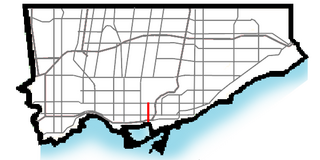
Parliament Street is a north–south street in the eastern part of downtown Toronto, Ontario, Canada. The street runs from Bloor Street to Queens Quay and is the first major street west of the Don River.


