
CKTB is a radio station in St. Catharines, Ontario, Canada. Broadcasting at 610 AM, the station airs a news/talk format. CKTB is housed in the former mansion of William Hamilton Merritt, the main promoter of the first Welland Canal, located on Yates Street in downtown St. Catharines. Its transmitters are located on Grassy Brook Road east of Port Robinson.

CKOC is a Canadian radio station, broadcasting at 1150 AM in Hamilton, Ontario. The station airs a Sports Radio format branded as TSN Radio and is owned by Bell Media. CKOC is a 50,000 watt, Class B station operating on a Regional broadcast frequency, with transmitters located near Empire Corners in Haldimand County, about 25 kilometers south of Hamilton. A six-tower directional antenna is used at all times. CKOC's studios are located on Upper Wentworth Street in Hamilton.

Burlington Street is a road in Hamilton, Ontario, stretching along the south shore of Hamilton Harbour in Lake Ontario. Burlington Street has four different statuses along the route. In its western terminus, it is a collector route ending at Bay Street North. Upon the intersection at Wellington Street, the road becomes an arterial route with four lanes. The Street ends at Parkdale Avenue. On October 14, 2015, city council approved the renaming of the upper portion of Burlington Street from 165 meters east of Ottawa St to the QEW to Nikola Tesla Boulevard.

James Street is a Lower City arterial road in Hamilton, Ontario, Canada. It starts off at the base of the Niagara Escarpment from James Mountain Road, a mountain-access road in the city, originally was a one-way street going south throughout but now has sections of it that are two-way. It extends north to the city's waterfront at the North End where it ends at Guise Street West right in front of the Harbour West Marina Complex and the Royal Hamilton Yacht Club.
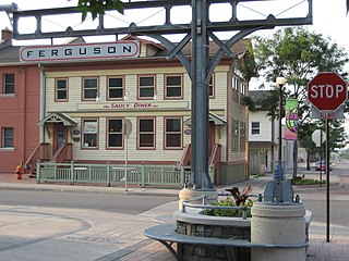
Ferguson Avenue is a Lower City collector road in Hamilton, Ontario, Canada. It is a two-way street throughout that starts off at the base of the Mountain on Foster Street. It's interrupted 3 blocks north at Corktown Park where Canadian Pacific Railway lines passes through it. Ferguson Avenue resumes again north of the Park right before Hunter Street East, extending northward past Barton Street East through the city's North End industrial neighbourhood where it ends on Dock Service Road, the site of a Royal Canadian Navy base and Pier 10.
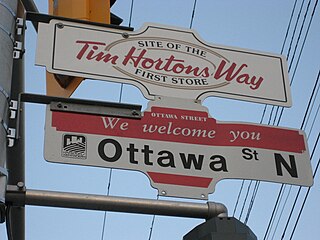
Ottawa Street is a Lower City arterial road in Hamilton, Ontario, Canada. It starts off at Lawrence Road at the base of the Niagara Escarpment (mountain) and is a two-way street throughout, cutting through the Delta and Crown Point neighbourhoods and the City's North End industrial neighbourhood. It ends at Industrial Drive, the site of the Dofasco steel company. This used to be one of the east ends' mountain access roads - it continued south over the train tracks at Lawrence Road and quickly turned right towards the brick manufacturing plant once known as Hamilton Brick. It took several turns before joining what is now the Kenilworth Access near the old water reservoir entrance. Its routing up the mountain is fairly consistent with the current Kenilworth Access with one exception - another hair-pin turn at the top; not the traffic circle that is present now. It was because of these hair-pin turns that the Hamilton Street Railway discontinued bus service on this road in 1944, and why the City planned a new Kenilworth Access to the east which opened in 1957.
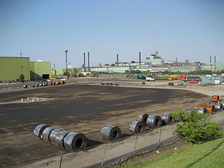
Kenilworth Avenue is a Lower City arterial road in Hamilton, Ontario, Canada. It starts off at the Kenilworth Traffic Circle and Kenilworth Access, a mountain-access road at the base of the Niagara Escarpment (mountain) and is a two-way street throughout stretching northward through the city's North End industrial neighbourhood where it then flows underneath the Burlington Street bridge and right into Dofasco's Industrial Park.

Parkdale Avenue, is a Lower City arterial road in Hamilton, Ontario, Canada. It starts off just South of Lawrence Road at Hixon Road and is a two-way street throughout, stretching northward through the city's North End industrial neighbourhood and ends just north of the Nikola Tesla Boulevard East overpass at the front gates of Triple M Metal LP, a scrap & waste management company.

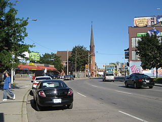
Barton Street is an arterial road in the Lower City of Hamilton, Ontario, Canada. It's also the longest street (21.0 km) in the city. It starts at the north end of downtown at Locke Street North and is a two-way street that stretches eastward through a number of different and varied communities in the city and ends in Winona at Fifty Road just west of the Hamilton/Niagara regional boundary. The street is divided in East and West portions, divided by James Street. However, the East designation does not continue through the Stoney Creek district, which was a separate municipality prior to amalgamation in 2001, and the designation as well as the address numbering system were not restructured upon amalgamation, and numbers reset at the former city limits at Centennial Parkway.
Wilson Street is a Lower City collector road in Hamilton, Ontario, Canada. It starts off at James Street North and works its way East and ends at Sherman Avenue North. The section between James Street and Ferguson Avenue was a one-way road, but was converted to a two-way street at 10 am on December 10, 2010.
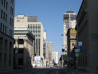
Main Street is a street in Hamilton, Ontario, Canada.

Hunter Street is a Lower City collector road in Hamilton, Ontario, Canada. It is a one-way street (Westbound) that starts West of Locke Street at Hill Street Park and ends two blocks East of Victoria Avenue at Emerald Street.
Charlton Avenue, is a Lower City collector road in Hamilton, Ontario, Canada. This collector road starts off just West of Dundurn Street as a one-way street (Westbound) up to James Street South where it then switches over to a two-way street the rest of the way eastward and ends at Wentworth Street South right in front of Mountain Face Park and the Escarpment Rail Trail.
Limeridge Road is a two-way Upper City (mountain) collector road in Hamilton, Ontario, Canada. It starts off just West of Garth Street/William McCulloch Park as Limeridge Court and cuts across the Hamilton mountain eastward running parallel with the Lincoln M. Alexander Parkway and ends at Mountain Brow Boulevard, South of Mohawk Sports Park in front of Upper King's Forest Park.
Stone Church Road, is a two-way Upper City (mountain) east-west arterial road in Hamilton, Ontario, Canada. It starts at Golf Links Road, just east of Meadowlands, and goes across the Escarpment and ends at Upper Mount Albion Road.

Lime Ridge Mall is a two-level indoor shopping mall in Hamilton, Ontario, Canada. Opened on September 13, 1981, it is the largest mall complex in the city, an 815,000-square-foot (75,700 m2) super-regional shopping centre with over 213 stores including department stores and big box stores such as Hudson's Bay and the former Sears. It is located on Upper Wentworth Street.
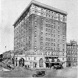
The Royal Connaught Hotel is a 13-storey building in downtown Hamilton, Ontario. It was built by Harry Frost of Buffalo, New York in 1914, who also started up and owned the Frost Fence Company in Hamilton. It is located at the corner of King Street East and John Street South. From 2014-2018 it was converted to a condominium.
Upper Wentworth Street is an Upper City road in Hamilton, Ontario, Canada. It starts off at Concession Street in the north and extends southward past Rymal Road. It is a two-way street throughout. As with most of the "Upper" streets, their addresses start at roughly the point where their lower counterpart finishes just below the Escarpment and were originally labeled without the "Upper" prefix.
Upper Sherman Avenue is an Upper City (mountain) arterial road in Hamilton, Ontario, Canada. It starts off north of Concession Street at Mountain Park Avenue and extends southward where it ends at Rymal Road. It is a two-way street throughout. As with most of the "Upper" streets, their addresses start at roughly the point where their lower counterpart finishes just below the Escarpment and were originally labelled without the "Upper" prefix.


