
Sherman Avenue is a collector road in the lower portion of Hamilton, Ontario, Canada. It begins at the Niagara Escarpment just south of Cumberland Avenue and is a one-way street bisecting the industrialized northern neighbourhoods of the city. It ends at Ship Street — the site of Steel Company of Canada (Stelco).

Gage Avenue is a Lower City arterial road in Hamilton, Ontario, Canada. It starts off at Lawrence Road at the base of the Niagara Escarpment (mountain) at the south end of Gage Park. It is a two-way arterial road that extends north through the city's North End industrial neighbourhood and ends at Industrial Drive.
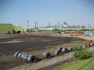
Kenilworth Avenue is a Lower City arterial road in Hamilton, Ontario, Canada. It starts off at the Kenilworth Traffic Circle and Kenilworth Access, a mountain-access road at the base of the Niagara Escarpment (mountain) and is a two-way street throughout stretching northward through the city's North End industrial neighbourhood where it then flows underneath the Burlington Street bridge and right into Dofasco's Industrial Park.

Barton Street is an arterial road in the Lower City of Hamilton, Ontario, Canada. It's also the longest street (21.0 km) in the city. It starts at the north end of downtown at Locke Street North and is a two-way street that stretches eastward through a number of different and varied communities in the city and ends in Winona at Fifty Road just west of the Hamilton/Niagara regional boundary. The street is divided in East and West portions, divided by James Street. However, the East designation does not continue through the Stoney Creek district, which was a separate municipality prior to amalgamation in 2001, and the designation as well as the address numbering system were not restructured upon amalgamation, and numbers reset at the former city limits at Centennial Parkway.
Wilson Street is a Lower City collector road in Hamilton, Ontario, Canada. It starts off at James Street North and works its way East and ends at Sherman Avenue North. The section between James Street and Ferguson Avenue was a one-way road, but was converted to a two-way street at 10 am on December 10, 2010.

King William Street is a Lower City collector road in Hamilton, Ontario, Canada. It starts off at the western-end at James Street North and is a one-way street (Eastbound) until Mary Street, where it becomes a two-way street that ends at Wentworth Street North. It is named after King William IV of the United Kingdom.
Augusta Street is a Lower City collector road in Hamilton, Ontario, Canada. A two-way collector road that starts off on James Street South and ends 4-blocks East at Shamrock Park just past Walnut Street South.
Charlton Avenue, is a Lower City collector road in Hamilton, Ontario, Canada. This collector road starts off just west of Dundurn Street as a one-way street (Westbound) up to James Street South where it then switches over to a two-way street the rest of the way eastward and ends at Wentworth Street South right in front of Mountain Face Park and the Escarpment Rail Trail.

Aberdeen Avenue is a Lower City minor arterial road in Hamilton, Ontario, Canada. It starts off just west of Longwood Road South and east of Highway 403 as a two-way thoroughfare up to Queen Street South, where it then switches over to a one-way collector road (eastbound) to Bay Street South and then to another two-way section from Bay Street to James Mountain Road, a mountain-access road in the city near the base of the Niagara Escarpment (mountain).
Limeridge Road is a two-way Upper City (mountain) collector road in Hamilton, Ontario, Canada. It starts off just west of Garth Street/William McCulloch Park as Limeridge Court and cuts across the Hamilton mountain eastward running parallel with the Lincoln M. Alexander Parkway and ends at Mountain Brow Boulevard, South of Mohawk Sports Park in front of Upper King's Forest Park.
Stone Church Road, is a two-way Upper City (mountain) east-west arterial road in Hamilton, Ontario, Canada. It starts at Golf Links Road, just east of Meadowlands, and goes across the Escarpment and ends at Upper Mount Albion Road.
Upper James Street, is an Upper City (mountain) arterial road in Hamilton, Ontario, Canada. It starts at the Claremont Access, a mountain-access road in the north, and extends southward towards the John C. Munro Hamilton International Airport where it then changes its name to the Hamilton Port Dover Plank Road,. It is a two-way street throughout. As with most of the "Upper" streets, their addresses start at roughly the point where their lower counterpart finishes just below the Escarpment and were originally labelled without the "Upper" prefix.
Upper Wellington Street is an Upper City (mountain) arterial road in Hamilton, Ontario, Canada. It starts at the Jolley Cut, a mountain-access road to the north, beside Sam Lawrence Park and extends southward past Rymal Road where it ends at the Mount Hamilton Cemetery. It is a two-way street throughout. As with most of the "Upper" streets, their addresses start at roughly the point where their lower counterpart finishes just below the Escarpment and were originally labelled without the "Upper" prefix.
Upper Gage Avenue is a Hamilton Mountain arterial road in Hamilton, Ontario, Canada. It starts off at Concession Street in front of Mountain Drive Park and works its way southward and ends just past Rymal Road beside Broughton West Park 2. It is a two-way street throughout. Upper Gage starts at roughly the point where its lower counterpart Gage Avenue finishes just below the Escarpment and was originally labelled without the "upper" prefix.
Upper Kenilworth Avenue is an Upper City (mountain) arterial road in Hamilton, Ontario, Canada. It starts off at Fennell Avenue in the north and extends southward just past Limeridge Road where it ends north of the Lincoln M. Alexander Parkway at Trenhome Park.
Nebo Road is an Upper City (mountain) road in Hamilton, Ontario, Canada. It starts at Stone Church Road East and extends southward where it ends at Chippewa Road East, just north of Lake Niapenco at the Binbrook Conservation Area.
West 5th Street is an Upper City (mountain) arterial road in Hamilton, Ontario, Canada. It starts off in the north at James Mountain Road, a mountain-access road, and extends southward past Rymal Road where it ends just south of Christopher Drive. It is a two-way street throughout.
Garth Street is an Upper City (mountain) arterial road in Hamilton, Ontario, Canada. It starts off at Beckett Drive, a mountain-access road in the north, and extends southward where it ends at Twenty Road just east of the Glancaster Golf and Country Club. It is a two-way street throughout.
Upper Paradise Road is an Upper City (mountain) collector road in Hamilton, Ontario, Canada. It starts off just north of Scenic Drive by Cliffview Park and extends southward where it ends just south of Rymal Road beside Carpenter Park. It is a two-way street throughout.
Upper Centennial Parkway is a mountain-access road in Hamilton, Ontario, Canada. Also known as Hamilton Highway 20, the road starts off at Centennial Parkway in the Lower City beside Battlefield Park and extends south up the Niagara Escarpment and southward across the mountain where it ends at Rymal Road. It is a two-way street throughout.
 ; Rymal Road East