
Ancaster—Dundas—Flamborough—Westdale was a federal electoral district in Ontario, Canada, that has been represented in the House of Commons of Canada from 2004 until the electoral boundaries were redrawn for the 2015 election.

Hamilton Mountain is a federal electoral district in Ontario, Canada, that has been represented in the House of Commons of Canada since 1968. The riding is located in the Hamilton region.
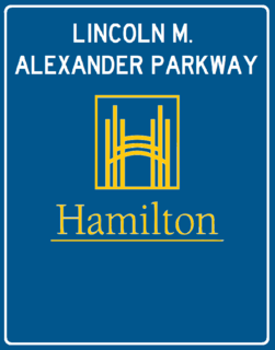
The Lincoln Alexander Parkway, nicknamed The Linc, is a municipal expressway in the Canadian city of Hamilton, Ontario, which connects Highway 403 with the Red Hill Valley Parkway, which continues north to the Queen Elizabeth Way (QEW). Collectively, the two expressways form a southern and eastern bypass of Hamilton. Located on the Hamilton mountain, atop the Niagara Escarpment, the freeway was named after the former Progressive Conservative MP and first black Lieutenant Governor of Ontario, Lincoln Alexander in July 1997, despite him never holding a driver's license.
King's Highway 20, commonly referred to as Highway 20, is a provincially maintained highway in the Canadian province of Ontario. Presently, it is a short 1.9 km (1.2 mi) stub between Highway 58 and Niagara Regional Road 70 in the City of Thorold, but until 1997 it connected Hamilton to Niagara Falls, serving several towns atop the Niagara Escarpment en route.

The Red Hill Valley Parkway (RHVP) is a municipal expressway in the Canadian city of Hamilton, Ontario. The route connects the Lincoln M. Alexander Parkway, Hamilton's second municipal expressway, to the Queen Elizabeth Way (QEW) near Hamilton Harbour. It is named after Red Hill Valley, through which it descends the Niagara Escarpment. It is a 7-kilometre (4.3 mi) four-lane freeway with a speed limit of 80 kilometres per hour (50 mph).
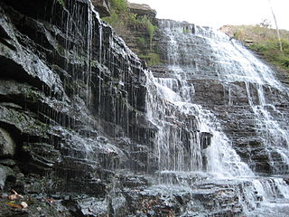
Albion Falls is a 19 m (62 ft) classical/cascade waterfall flowing down the Niagara Escarpment in Red Hill Valley, in Hamilton, Ontario, Canada. With cascade falls the downpour is staggered into a series of steps causing water to "cascade". The top of the falls are located on Mountain Brow Blvd. The lower-end of the falls can be found at the south-end of King's Forest Park in lower Hamilton by following the Red Hill Creek south towards the Niagara Escarpment.
Clementina Trenholm Fessenden was a Canadian author and social organiser. She was also the mother of Reginald Fessenden, the radio pioneer.

Centennial Parkway, is a Lower City arterial road in Hamilton, Ontario, Canada. It is best known as the western terminus of former King's Highway 20, now maintained by the City of Hamilton. It starts off as Upper Centennial Parkway, a mountain-access road in the City right before the Canadian Pacific Railway line at the backend of Battlefield Park and is a two-way street throughout that extends north over the Queen Elizabeth Way and ends at Beach Boulevard/ Van Wagners Beach Road in front of Confederation Park.

Cannon Street, is a Lower City collector road in Hamilton, Ontario, Canada. It starts off at Queen Street North as a one-way street (Westbound) up to Sherman Avenue North where it then switches over to a two-way street the rest of the way Eastward and ends just past Kenilworth Avenue North on Barons Avenue and merges with Britannia Avenue, a street that runs parallel with Cannon Street from Ottawa Street North to Barons Avenue.
Charlton Avenue, is a Lower City collector road in Hamilton, Ontario, Canada. This collector road starts off just west of Dundurn Street as a one-way street (Westbound) up to James Street South where it then switches over to a two-way street the rest of the way eastward and ends at Wentworth Street South right in front of Mountain Face Park and the Escarpment Rail Trail.

Mohawk Road is an Upper City (mountain) arterial road in Hamilton, Ontario, Canada. It is a two-way street throughout that starts just west of Highway 403 & Meadowlands and travels eastward linking up with the Lincoln M. Alexander Parkway. Mohawk Road east of Highway 403 resumes again in front of Iroquoia Heights Conservation Area, and runs parallel with the Lincoln M. Alexander Parkway, cuts across the Hamilton mountain and ends at Mountain Brow Boulevard, the site of Mohawk Sports Park.
Stone Church Road, is a two-way Upper City (mountain) east-west arterial road in Hamilton, Ontario, Canada. It starts at Golf Links Road, just east of Meadowlands, and goes across the Escarpment and ends at Upper Mount Albion Road.
Upper James Street, is an Upper City (mountain) arterial road in Hamilton, Ontario, Canada. It starts at the Claremont Access, a mountain-access road in the north, and extends southward towards the John C. Munro Hamilton International Airport where it then changes its name to the Hamilton Port Dover Plank Road,. It is a two-way street throughout. As with most of the "Upper" streets, their addresses start at roughly the point where their lower counterpart finishes just below the Escarpment and were originally labelled without the "Upper" prefix.
Upper Wellington Street is an Upper City (mountain) arterial road in Hamilton, Ontario, Canada. It starts at the Jolley Cut, a mountain-access road to the north, beside Sam Lawrence Park and extends southward past Rymal Road where it ends at the Mount Hamilton Cemetery. It is a two-way street throughout. As with most of the "Upper" streets, their addresses start at roughly the point where their lower counterpart finishes just below the Escarpment and were originally labelled without the "Upper" prefix.
Upper Gage Avenue is a Hamilton Mountain arterial road in Hamilton, Ontario, Canada. It starts off at Concession Street in front of Mountain Drive Park and works its way southward and ends just past Rymal Road beside Broughton West Park 2. It is a two-way street throughout. Upper Gage starts at roughly the point where its lower counterpart Gage Avenue finishes just below the Escarpment and was originally labelled without the "upper" prefix.
West 5th Street is an Upper City (mountain) arterial road in Hamilton, Ontario, Canada. It starts off in the north at James Mountain Road, a mountain-access road, and extends southward past Rymal Road where it ends just south of Christopher Drive. It is a two-way street throughout.
Garth Street is an Upper City (mountain) arterial road in Hamilton, Ontario, Canada. It starts off at Beckett Drive, a mountain-access road in the north, and extends southward where it ends at Twenty Road just east of the Glancaster Golf and Country Club. It is a two-way street throughout.
Upper Paradise Road is an Upper City (mountain) collector road in Hamilton, Ontario, Canada. It starts off just north of Scenic Drive by Cliffview Park and extends southward where it ends just south of Rymal Road beside Carpenter Park. It is a two-way street throughout.
Upper Centennial Parkway is a mountain-access road in Hamilton, Ontario, Canada. Also known as Hamilton Highway 20, the road starts off at Centennial Parkway in the Lower City beside Battlefield Park and extends south up the Niagara Escarpment and southward across the mountain where it ends at Rymal Road. It is a two-way street throughout.
 ; Rymal Road, West/East