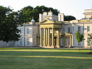
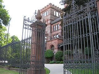
Dundurn Castle is a historic neoclassical mansion on York Boulevard in Hamilton, Ontario, Canada. The 1,700-square-metre (18,000 sq ft) house took three years and $175,000 to build and was completed in 1835.
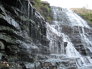
Albion Falls is a 19 m (62 ft) classical/cascade waterfall flowing down the Niagara Escarpment in Red Hill Valley, in Hamilton, Ontario, Canada. With cascade falls the downpour is staggered into a series of steps causing water to "cascade". The top of the falls are located on Mountain Brow Blvd. The lower-end of the falls can be found at the south-end of King's Forest Park in lower Hamilton by following the Red Hill Creek south towards the Niagara Escarpment.
Hamilton is located on the western end of the Niagara Peninsula and wraps around the westernmost part of the Lake Ontario. Most of the city including the downtown section lies along the south shore. Situated in the geographic centre of the Golden Horseshoe, it lies roughly midway between Toronto and Buffalo. The two major physical features are Hamilton Harbour marking the northern limit of the city and the Niagara Escarpment running through the middle of the city across its entire breadth, bisecting the city into 'upper' and 'lower' parts.

Hess Village is a pedestrianized area in the downtown of Hamilton, Ontario, Canada. Its streets, in contrast to other areas in Hamilton, are quite thin and restrict vehicle access. It is located between Main and King Street, and a block north west of city hall. It is home to various amenities and shops, notably nightclubs, bars, and historic buildings. It is named after Hess Street, a north-south Lower City collector street that travels through the centre of the area.
Queen Street is a Lower City arterial road in Hamilton, Ontario, Canada. It starts off at Beckett Drive, a mountain-access road in the city and is a two-way street up to King Street West and a one-way street (southbound) the rest of the way north up to the Canadian National Railway Yard, where the road turns right, merging with Stuart Street which travels in a west–east direction.
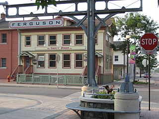
Ferguson Avenue is a Lower City collector road in Hamilton, Ontario, Canada. It is a two-way street throughout that starts off at the base of the Mountain on Foster Street. It's interrupted 3 blocks north at Corktown Park where Canadian Pacific Railway lines passes through it. Ferguson Avenue resumes again north of the Park right before Hunter Street East, extending northward past Barton Street East through the city's North End industrial neighbourhood where it ends on Dock Service Road, the site of a Royal Canadian Navy base and Pier 10.

Wentworth Street is a Lower City arterial road in Hamilton, Ontario, Canada. It starts off at the base of the Niagara Escarpment (mountain) on Charlton Avenue East just south of the CP lines and runs right through the city's North End industrial neighbourhood and ends north of Burlington Street East at Pier 14, which one time was used by International Harvester (1902–1992).

Sherman Avenue is a collector road in the lower portion of Hamilton, Ontario, Canada. It begins at the Niagara Escarpment just south of Cumberland Avenue and is a one-way street bisecting the industrialized northern neighbourhoods of the city. It ends at Ship Street — the site of Steel Company of Canada (Stelco).

Gage Avenue is a Lower City arterial road in Hamilton, Ontario, Canada. It starts off at Lawrence Road at the base of the Niagara Escarpment (mountain) at the south end of Gage Park. It is a two-way arterial road that extends north through the city's North End industrial neighbourhood and ends at Industrial Drive.
Kenilworth Avenue is a Lower City arterial road in Hamilton, Ontario, Canada. It starts off at the Kenilworth Traffic Circle and Kenilworth Access, a mountain-access road at the base of the Niagara Escarpment (mountain) and is a two-way street throughout stretching northward through the city's North End industrial neighbourhood where it then flows underneath the Burlington Street bridge and right into Dofasco's Industrial Park.

Centennial Parkway is an arterial road in southeastern Hamilton, Ontario, Canada. It is best known as the western terminus of the former King's Highway 20, now maintained by the City of Hamilton. It starts off as Upper Centennial Parkway, a mountain-access road in the City right before the Canadian Pacific Railway line at the backend of Battlefield Park, and is a two-way street throughout that extends north over the Queen Elizabeth Way and ends at Beach Boulevard/Van Wagners Beach Road in front of Confederation Park.

Hunter Street is a Lower City collector road in Hamilton, Ontario, Canada. It is a one-way street (Westbound) that starts West of Locke Street at Hill Street Park and ends two blocks East of Victoria Avenue at Emerald Street. Hunter Street is a two-way street between Victoria and Emerald Streets.

Aberdeen Avenue is a Lower City minor arterial road in Hamilton, Ontario, Canada. It starts off just west of Longwood Road South and east of Highway 403 as a two-way thoroughfare up to Queen Street South, where it then switches over to a one-way collector road (eastbound) to Bay Street South and then to another two-way section from Bay Street to James Mountain Road, a mountain-access road in the city near the base of the Niagara Escarpment (mountain).

The Chedoke Creek is an urban creek that runs through the west end of Hamilton, Ontario. It crosses the Bruce Trail and the Radial Trail.
Upper James Street, is an Upper City (mountain) arterial road in Hamilton, Ontario, Canada. It starts at the Claremont Access, a mountain-access road in the north, and extends southward towards the John C. Munro Hamilton International Airport where it then changes its name to the Hamilton Port Dover Plank Road,. It is a two-way street throughout. As with most of the "Upper" streets, their addresses start at roughly the point where their lower counterpart finishes just below the Escarpment and were originally labelled without the "Upper" prefix.
Upper Centennial Parkway is a mountain-access road in Hamilton, Ontario, Canada. Also known as Hamilton Highway 20, the road begins at its north end at Centennial Parkway in the Lower City of Hamilton beside Battlefield Park, and extends south up the Niagara Escarpment and southward across the mountain where it ends at Rymal Road. It is a two-way street throughout. South of Rymal Road, it continues as Regional Road 56.

The Strathcona neighbourhood is located west of downtown Hamilton, Ontario, and is bounded by Highway 403, the CNR rail line, Queen Street, York Boulevard and Main Street. The neighbourhood is also intersected by several other major street arteries: Dundurn Street, Locke Street, and King Street West. As of the 2016 census, Strathcona has a population of 6,555, up from 5,800 in the 1996 census.