List of waterfalls in Hamilton, Ontario

Last updated

Webster's Falls Waterdawn Webster Falls5.jpg
Webster's Falls

The city of Hamilton in Ontario, Canada is home to more than 100 waterfalls and cascades, most of which are on or near the Bruce Trail as it winds through the Niagara Escarpment. Ontario's internationally recognized Niagara Escarpment provides perfect geological conditions for waterfalls to occur, from Tobermory to Niagara Falls.

Contents

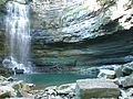
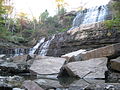
With its 30 metres (98 ft) crest, Webster's Falls is the largest waterfall within the city. [1] Tew's Falls is a 41 metres (135 ft) ribbon waterfall, and is the tallest waterfall found in Hamilton. Both Webster's and Tew's are located at the Spencer Gorge / Webster's Falls Conservation Area. [1] Albion Falls was once seriously considered as a possible source of water for Hamilton. Rocks from the Albion Falls area were used in the construction of the Royal Botanical Gardens' Rock Garden. [2]

There used to be more waterfalls in Hamilton than exist today. Many of the waterfalls in central Hamilton slowly vanished as population and construction on Hamilton Mountain increased. As well, in the early years, James Street extended south, but was interrupted by a bog at Hunter Street which eventually (1844) was drained out and graded. [3] [ page needed ] Many of Hamilton's main buildings and factories in the north end are built on reclaimed or infilled land, which harmed the drainage of Hamilton and the water ecology of Hamilton Harbour.

Many of the falls in west Hamilton are accessible from the Chedoke Radial Trail. It is built on what was once the route for the Brantford and Hamilton Electric Railway owned by the Cataract Power Light and Traction Company (later Dominion Power and Transmission). [4] The "Five Johns", (John Cameron, John Dickenson (Canadian politician), John Morison Gibson, John Moodie, Sr. and John Sutherland), formed The Cataract Power Co. Ltd. introducing electric power to Hamilton in 1898. On August 25, 1898, power was sent twenty seven miles from DeCew Falls, St. Catharines, using water from the old Welland Canal. New industries, such as the forerunners of the Steel Co. of Canada (Stelco) and Canadian Westinghouse, were attracted here by the cheaper, more efficient power. One time this Company controlled hydro power from Brantford to St. Catharines, including the Hamilton Street Railway and the area's radial lines. Back then the city's nickname was "The Electric City." [5]

Niagara Escarpment (in red) Niagara Escarpment map.png
Niagara Escarpment (in red)

There are four waterfall types and they are designated as follows:

Some of the criteria used to define a separate Hamilton waterfall include: The waterfall has to have a vertical drop of at least 3 metres or 10 feet (3.0 m) either as a vertical drop or a cascade, the crest width has to be at least 1 metre or 3 feet (0.91 m) wide, the waterfall must have some natural component and not be entirely man-made; If a waterfall is beside another waterfall but coming from two separate creeks or streams, then they could be considered as two separate waterfalls and the waterfall has to be located within the boundaries of the new City of Hamilton. [6]

On January 1, 2001 the new city of Hamilton was formed from the amalgamation of the Regional Municipality of Hamilton-Wentworth and its six municipalities: Hamilton, Ancaster, Dundas, Flamborough, Glanbrook, and Stoney Creek. Before amalgamation, Hamilton had a population of 331,121 divided into 100 neighbourhoods. The new amalgamated city had 490,268 people in over 200 neighbourhoods. [3] [ page needed ]

Waterfalls list

The Hamilton Conservation Authority maintains a web database of the city's waterfalls. The list below comes from that website, which contains 100 waterfalls. [7]

PhotoNameHeightWidthCoordinates
Albion Falls, Hamilton,..jpg Albion Falls 62.32 feet (19.00 m)59.04 feet (18.00 m) 43°12′01″N79°49′11″W / 43.2004°N 79.8196°W / 43.2004; -79.8196
Blank - Spacer.png Ancaster Heights Falls 43.952 feet (13.397 m)5.904 feet (1.800 m) 43°14′23″N79°57′46″W / 43.2397°N 79.9628°W / 43.2397; -79.9628
Blank - Spacer.png Auchmar Falls 40 feet (12 m)5 feet (1.5 m) 43°14′37″N79°53′28″W / 43.2436°N 79.8912°W / 43.2436; -79.8912
Blank - Spacer.png Baby Albion Falls 28 feet (8.5 m)3 feet (0.91 m) 43°12′00″N79°49′11″W / 43.2001°N 79.8196°W / 43.2001; -79.8196
Waterdawn Webster Baby Falls1.jpg Baby Webster Falls 29.52 feet (9.00 m)9.84 feet (3.00 m) 43°16′33″N79°58′55″W / 43.2757°N 79.9819°W / 43.2757; -79.9819
Blank - Spacer.png Beckett Falls 10 feet (3.0 m)4 feet (1.2 m) 43°14′42″N79°53′09″W / 43.2449°N 79.8858°W / 43.2449; -79.8858
Blank - Spacer.png Billy Green Falls 55.76 feet (17.00 m)19.68 feet (6.00 m) 43°12′26″N79°45′59″W / 43.2072°N 79.7664°W / 43.2072; -79.7664
Billy Monkley Cascade (35596122764).jpg Billy Monkley Cascade 10 feet (3.0 m)21 feet (6.4 m) 43°11′25″N79°49′49″W / 43.1904°N 79.8304°W / 43.1904; -79.8304
Blank - Spacer.png Blue Falls 13 feet (4.0 m)10 feet (3.0 m)
Borer's Falls.jpg Borer's Falls 49.2 feet (15.0 m)16.4 feet (5.0 m) 43°17′38″N79°56′12″W / 43.2938°N 79.9368°W / 43.2938; -79.9368
Blank - Spacer.png Broman Falls 22 feet (6.7 m)3 feet (0.91 m) 43°12′51″N79°48′58″W / 43.2142°N 79.816°W / 43.2142; -79.816
Buttermilk FallsA.jpg Buttermilk Falls75.44 feet (22.99 m)26.24 feet (8.00 m) 43°12′19″N79°49′11″W / 43.2053°N 79.8196°W / 43.2053; -79.8196
Blank - Spacer.png Canterbury Falls 29.52 feet (9.00 m)13.12 feet (4.00 m) 43°14′13″N79°58′51″W / 43.237°N 79.9807°W / 43.237; -79.9807
Blank - Spacer.png Cave Falls 50 feet (15 m)10 feet (3.0 m)
Blank - Spacer.png Centennial Falls 32.8 feet (10.0 m)13.12 feet (4.00 m) 43°12′31″N79°46′07″W / 43.2086°N 79.7685°W / 43.2086; -79.7685
Chedoke Falls - panoramio (4).jpg Chedoke Falls 59.04 feet (18.00 m)29.52 feet (9.00 m)
Blank - Spacer.png Clappison Falls 23 feet (7.0 m)10 feet (3.0 m)
Blank - Spacer.png Cliffview Falls 49.2 feet (15.0 m)9.84 feet (3.00 m) 43°14′39″N79°54′28″W / 43.2443°N 79.9079°W / 43.2443; -79.9079
Spencer Gorge Cons. Area Laslovarga (23).jpg Darnley Cascade 13.12 feet (4.00 m)72.16 feet (21.99 m) 43°16′38″N80°00′24″W / 43.2772°N 80.0068°W / 43.2772; -80.0068
Denlow.jpeg Denlow Falls 62.32 feet (19.00 m)29.52 feet (9.00 m)
Devils Pouch Bowl Conservation Area- Hamilton-Ontario (1).jpg Devil's Punch Bowl Falls 121.36 feet (36.99 m)9.84 feet (3.00 m) 43°12′37″N79°45′21″W / 43.2103°N 79.7559°W / 43.2103; -79.7559
Blank - Spacer.png Dewitt Falls 22.96 feet (7.00 m)6.56 feet (2.00 m) 43°12′24″N79°43′06″W / 43.2068°N 79.7184°W / 43.2068; -79.7184
Blank - Spacer.png Duchess Falls 13 feet (4.0 m)5 feet (1.5 m)
Blank - Spacer.png Dundas Falls 20.992 feet (6.398 m)21.976 feet (6.698 m) 43°16′23″N79°58′20″W / 43.273°N 79.9722°W / 43.273; -79.9722
Blank - Spacer.png Dyment Falls 51.496 feet (15.696 m)13.12 feet (4.00 m) 43°16′42″N79°56′57″W / 43.2782°N 79.9491°W / 43.2782; -79.9491
Blank - Spacer.png East Glover's Falls19.68 feet (6.00 m)9.84 feet (3.00 m)
Blank - Spacer.png East Greensville Falls 18.04 feet (5.50 m)4.92 feet (1.50 m) 43°16′46″N79°59′29″W / 43.2794°N 79.9915°W / 43.2794; -79.9915
Blank - Spacer.png East Iroquoia Falls65.6 feet (20.0 m)3.936 feet (1.200 m) 43°14′41″N79°56′19″W / 43.2448°N 79.9386°W / 43.2448; -79.9386
Blank - Spacer.png East of Fifty Falls 32.8 feet (10.0 m)4.92 feet (1.50 m) 43°11′42″N79°38′29″W / 43.1949°N 79.6414°W / 43.1949; -79.6414
Felker's Falls - panoramio (2).jpg Felker's Falls 72.16 feet (21.99 m)19.68 feet (6.00 m) 43°12′13″N79°47′25″W / 43.2035°N 79.7902°W / 43.2035; -79.7902
Ferguson Falls.jpg Ferguson Falls 97 feet (30 m)6 feet (1.8 m)
Blank - Spacer.png Fifty Road Cascade 32.8 feet (10.0 m)3.936 feet (1.200 m) 43°11′41″N79°38′40″W / 43.1946°N 79.6445°W / 43.1946; -79.6445
Blank - Spacer.png Glover's Falls 26.24 feet (8.00 m)9.84 feet (3.00 m)
Blank - Spacer.png Grand Cascade 13.12 feet (4.00 m)3.28 feet (1.00 m) 43°11′46″N79°39′00″W / 43.1962°N 79.6501°W / 43.1962; -79.6501
Great Falls - Waterdown.jpg Great Falls 32.8 feet (10.0 m)16.4 feet (5.0 m) 43°19′50″N79°53′14″W / 43.3305°N 79.8872°W / 43.3305; -79.8872
Blank - Spacer.png Grindstone Cascade 9.84 feet (3.00 m)16.4 feet (5.0 m) 43°19′42″N79°53′13″W / 43.3284°N 79.8869°W / 43.3284; -79.8869
Blank - Spacer.png Hannon Cascade 10 feet (3.0 m)18 feet (5.5 m)
Blank - Spacer.png Harvey Falls 52.48 feet (16.00 m)9.84 feet (3.00 m) 43°11′59″N79°39′35″W / 43.1998°N 79.6597°W / 43.1998; -79.6597
Blank - Spacer.png Heritage Falls 16.4 feet (5.0 m)9.84 feet (3.00 m) 43°14′24″N80°00′14″W / 43.24°N 80.0039°W / 43.24; -80.0039
Blank - Spacer.png Heritage Green Falls 40 feet (12 m)6 feet (1.8 m) 43°12′17″N79°47′15″W / 43.2047°N 79.7875°W / 43.2047; -79.7875
Blank - Spacer.png Hermitage Cascade 13.12 feet (4.00 m)16.4 feet (5.0 m) 43°14′11″N79°59′53″W / 43.2364°N 79.998°W / 43.2364; -79.998
Blank - Spacer.png Hidden Grindstone Falls 26 feet (7.9 m)5 feet (1.5 m)
Blank - Spacer.png Jones Road Falls 19.68 feet (6.00 m)6.56 feet (2.00 m) 43°12′13″N79°41′44″W / 43.2035°N 79.6956°W / 43.2035; -79.6956
Blank - Spacer.png Lewis Road East Falls 26.24 feet (8.00 m)16.4 feet (5.0 m) 43°12′02″N79°39′54″W / 43.2005°N 79.665°W / 43.2005; -79.665
Blank - Spacer.png Lewis Road West Falls 29.52 feet (9.00 m)9.84 feet (3.00 m) 43°12′01″N79°39′57″W / 43.2003°N 79.6657°W / 43.2003; -79.6657
Blank - Spacer.png Limeridge Falls 50 feet (15 m)3 feet (0.91 m)
Blank - Spacer.png Little Canterbury Falls 16.4 feet (5.0 m)6.56 feet (2.00 m) 43°14′13″N79°58′48″W / 43.2369°N 79.98°W / 43.2369; -79.98
Little Davis Falls Red Hill Valley.JPG Little Davis Falls9.84 feet (3.00 m)26.24 feet (8.00 m) 43°12′24″N79°47′20″W / 43.2067°N 79.7889°W / 43.2067; -79.7889
Blank - Spacer.png Little Falls22.96 feet (7.00 m)9.84 feet (3.00 m) 43°14′22″N79°57′56″W / 43.2395°N 79.9656°W / 43.2395; -79.9656
Blank - Spacer.png Lower Borer's Falls 9.84 feet (3.00 m)16.4 feet (5.0 m)
Lower Chedoke Falls - panoramio (3).jpg Lower Chedoke Falls 19.68 feet (6.00 m)36.08 feet (11.00 m) 43°14′39″N79°54′01″W / 43.2442°N 79.9004°W / 43.2442; -79.9004
Blank - Spacer.png Lower Cliffview Falls 13.12 feet (4.00 m)9.84 feet (3.00 m) 43°14′45″N79°54′30″W / 43.2457°N 79.9084°W / 43.2457; -79.9084
Blank - Spacer.png Lower Glendale Falls 11 feet (3.4 m)13 feet (4.0 m)
Blank - Spacer.png Lower Hopkins Cascade 19.68 feet (6.00 m)11.48 feet (3.50 m) 43°17′48″N79°55′45″W / 43.2966°N 79.9292°W / 43.2966; -79.9292
Blank - Spacer.png Lower Little Falls 26.896 feet (8.198 m)5.904 feet (1.800 m) 43°14′24″N79°57′57″W / 43.24°N 79.9657°W / 43.24; -79.9657
Blank - Spacer.png Lower Mill Falls 19.68 feet (6.00 m)13.12 feet (4.00 m) 43°14′02″N79°58′25″W / 43.234°N 79.9735°W / 43.234; -79.9735
Blank - Spacer.png Lower Mohawk Falls 20 feet (6.1 m)12 feet (3.7 m)
Blank - Spacer.png Lower Princess Falls 129.8 feet (39.6 m)9.84 feet (3.00 m) 43°14′45″N79°55′48″W / 43.2459°N 79.9299°W / 43.2459; -79.9299
Lower punchbowl falls - Flickr - LukeDetwiler.jpg Lower Punchbowl Falls 19.68 feet (6.00 m)19.68 feet (6.00 m) 43°12′40″N79°45′26″W / 43.2111°N 79.7573°W / 43.2111; -79.7573
Blank - Spacer.png Lower Sanitorium Cascade 13.12 feet (4.00 m)9.84 feet (3.00 m) 43°14′46″N79°54′54″W / 43.246°N 79.9149°W / 43.246; -79.9149
Blank - Spacer.png Lower Scenic Cascade 10 feet (3.0 m)4 feet (1.2 m)
Blank - Spacer.png Lower Sydenham Falls 13.12 feet (4.00 m)13.12 feet (4.00 m) 43°16′26″N79°57′30″W / 43.274°N 79.9584°W / 43.274; -79.9584
Waterfall at Dundas Peak, Ontario.jpg Lower Tew's Falls 12.136 feet (3.699 m)21.976 feet (6.698 m)
Blank - Spacer.png Lower Westcliffe Falls 29.52 feet (9.00 m)19.68 feet (6.00 m) 43°14′45″N79°54′30″W / 43.2457°N 79.9084°W / 43.2457; -79.9084
Blank - Spacer.png McNeilly Falls 39.36 feet (12.00 m)6.56 feet (2.00 m)
Blank - Spacer.png Middle Glendale Falls 10 feet (3.0 m)11 feet (3.4 m) 43°12′09″N79°48′34″W / 43.2025°N 79.8094°W / 43.2025; -79.8094
Mill Falls -Ancaster Heights- Hamilton-Ontario.jpg Mill Falls 22.96 feet (7.00 m)13.12 feet (4.00 m) 43°14′00″N79°58′26″W / 43.2334°N 79.9739°W / 43.2334; -79.9739
Blank - Spacer.png Mineral Springs Falls 9.84 feet (3.00 m)6.56 feet (2.00 m) 43°14′11″N80°00′45″W / 43.2364°N 80.0124°W / 43.2364; -80.0124
Blank - Spacer.png Mountain Spring Falls 50 feet (15 m)8 feet (2.4 m) 43°12′16″N79°47′17″W / 43.2045°N 79.788°W / 43.2045; -79.788
Blank - Spacer.png Mountview Falls 32.8 feet (10.0 m)19.68 feet (6.00 m) 43°14′44″N79°55′17″W / 43.2455°N 79.9214°W / 43.2455; -79.9214
Blank - Spacer.png Oak Knoll Falls 25 feet (7.6 m)4 feet (1.2 m)
Blank - Spacer.png Patterson East Cascade 15 feet (4.6 m)5 feet (1.5 m) 43°17′54″N79°55′38″W / 43.2982°N 79.9271°W / 43.2982; -79.9271
Blank - Spacer.png Patterson West Cascade 14 feet (4.3 m)4 feet (1.2 m) 43°17′52″N79°55′40″W / 43.2979°N 79.9277°W / 43.2979; -79.9277
Blank - Spacer.png Princess Falls 22.96 feet (7.00 m)6.56 feet (2.00 m) 43°14′45″N79°55′48″W / 43.2458°N 79.9299°W / 43.2458; -79.9299
Blank - Spacer.png Pritchard Falls 15 feet (4.6 m)3 feet (0.91 m) 43°12′04″N79°48′59″W / 43.2011°N 79.8163°W / 43.2011; -79.8163
Blank - Spacer.png Progreston Falls 21.976 feet (6.698 m)54.12 feet (16.50 m) 43°23′53″N79°57′36″W / 43.3981°N 79.9599°W / 43.3981; -79.9599
Blank - Spacer.png Promontory Falls 59.04 feet (18.00 m)3.28 feet (1.00 m) 43°11′54″N79°39′08″W / 43.1982°N 79.6523°W / 43.1982; -79.6523
Blank - Spacer.png Puddicombe Falls 19.68 feet (6.00 m)6.56 feet (2.00 m) 43°11′40″N79°38′16″W / 43.1945°N 79.6379°W / 43.1945; -79.6379
Blank - Spacer.png Rock Chapel Falls 26.24 feet (8.00 m)4.92 feet (1.50 m) 43°17′28″N79°56′12″W / 43.2911°N 79.9366°W / 43.2911; -79.9366
Blank - Spacer.png Romar Cascade 23 feet (7.0 m)4 feet (1.2 m)
Blank - Spacer.png Scenic Falls 65.6 feet (20.0 m)19.68 feet (6.00 m) 43°14′39″N79°56′05″W / 43.2442°N 79.9348°W / 43.2442; -79.9348
Sherman Falls - panoramio - Eric Marshall (4).jpg Sherman Falls 55.76 feet (17.00 m)26.24 feet (8.00 m) 43°14′17″N79°58′22″W / 43.2381°N 79.9729°W / 43.2381; -79.9729
Blank - Spacer.png Smith Cascade 15 feet (4.6 m)6.5 feet (2.0 m)
Blank - Spacer.png Snake Falls 82 feet (25 m)9.84 feet (3.00 m)
Blank - Spacer.png Steven's Falls 26.24 feet (8.00 m)16.4 feet (5.0 m)
Blank - Spacer.png Sugar Shack Falls 30 feet (9.1 m)13 feet (4.0 m) 43°17′04″N79°56′15″W / 43.2845°N 79.9375°W / 43.2845; -79.9375
Tew's Falls at Sunset.jpg Tew's Falls 134.48 feet (40.99 m)29.52 feet (9.00 m) 43°16′51″N79°58′42″W / 43.2807°N 79.9783°W / 43.2807; -79.9783
Tiffany Falls, Hamilton (6663519687).jpg Tiffany Falls 68.88 feet (20.99 m)19.68 feet (6.00 m) 43°14′18″N79°57′29″W / 43.2382°N 79.9581°W / 43.2382; -79.9581
Blank - Spacer.png Upper Glendale Falls 9.84 feet (3.00 m)9.84 feet (3.00 m) 43°12′08″N79°48′35″W / 43.2023°N 79.8097°W / 43.2023; -79.8097
Blank - Spacer.png Upper Hopkins Cascade 10.496 feet (3.199 m)7.544 feet (2.299 m)
Blank - Spacer.png Upper Mohawk Cascade 10 feet (3.0 m)8 feet (2.4 m)
Blank - Spacer.png Upper Quarry Cascade 13.12 feet (4.00 m)3.936 feet (1.200 m) 43°18′48″N79°54′23″W / 43.3134°N 79.9064°W / 43.3134; -79.9064
Blank - Spacer.png Upper Sanatorium Falls 29.52 feet (9.00 m)9.84 feet (3.00 m) 43°14′41″N79°54′53″W / 43.2447°N 79.9148°W / 43.2447; -79.9148
Blank - Spacer.png Valley Falls 14 feet (4.3 m)14 feet (4.3 m) 43°17′51″N79°55′42″W / 43.2975°N 79.9283°W / 43.2975; -79.9283
Blank - Spacer.png Veevers Falls 45.92 feet (14.00 m)8.2 feet (2.5 m) 43°12′30″N79°46′51″W / 43.2082°N 79.7809°W / 43.2082; -79.7809
Blank - Spacer.png Walnut Grove Falls 15 feet (4.6 m)3.6 feet (1.1 m)
Washboard Falls (Close-Up).JPG Washboard Falls 16.4 feet (5.0 m)19.68 feet (6.00 m)
Webster Falls (49139224).jpeg Webster Falls 72.16 feet (21.99 m)98.4 feet (30.0 m) 43°16′34″N79°58′51″W / 43.2762°N 79.9809°W / 43.2762; -79.9809
Blank - Spacer.png Wesley Cascade 13 feet (4.0 m)3 feet (0.91 m)
Blank - Spacer.png West Iroquoia Falls 64.944 feet (19.795 m)3.28 feet (1.00 m) 43°14′39″N79°56′25″W / 43.2442°N 79.9404°W / 43.2442; -79.9404
Blank - Spacer.png West Moss Cascade 10 feet (3.0 m)3 feet (0.91 m)
Blank - Spacer.png West of Fifty Upper Cascade 26.24 feet (8.00 m)4.92 feet (1.50 m) 43°11′45″N79°38′52″W / 43.1957°N 79.6477°W / 43.1957; -79.6477
Blank - Spacer.png Westcliffe Falls 49.2 feet (15.0 m)6.56 feet (2.00 m) 43°14′43″N79°54′31″W / 43.2454°N 79.9085°W / 43.2454; -79.9085

Water Quality Problems

Many of Hamilton's creeks and waterfalls, especially those in the heavily-urbanized Chedoke and Red Hill creek watersheds, suffer from chronic water quality problems. Much of these systems have been buried in large underground concrete storm sewers that run under neighbourhoods established decades ago atop the Niagara escarpment. Industrial and residential use through the 19th, 20th and 21st centuries have caused, and continue to cause, substantial environmental damage to these watersheds. While the city of Hamilton has invested in wastewater storage tanks and tunnels in recent years, as of 2020, water testing performed by non-governmental monitoring bodies continues to reveal high e. coli counts. While the City of Hamilton's website does state that some waterfalls may be polluted and discourages entering the water around waterfalls, it does not state which ones are polluted, nor does the city test the water at any waterfall locations, since it does not designate them as official swimming areas.

Chedoke Falls and Watershed

In March 2020, it was revealed that as much as 24 billion litres of untreated wastewater had been leaking into Chedoke creek since at least 2014 due to insufficiencies in Hamilton's sewerage and stormwater management system. [8] Chedoke falls is often listed as one of Hamilton's 10 most popular waterfalls, and visitors can regularly be seen swimming and wading in its waters. The Chedoke creek watershed has seen regular discharges of raw sewage for the past century; today, untreated wastewater is discharged into the river regularly during rainstorms, when the city's Combined Sewer Overflows (CSO's) and a 77 million litre concrete wastewater storage tank are incapable of handling increased water volumes. [9] The storm sewer feeding Chedoke falls has also been plagued by incorrectly-installed sanitary sewer cross-connections from the residential neighbourhoods it runs beneath. The amount of raw sewage flowing into the creek on an ongoing basis is unknown. [9] These problems are compounded by the fact that the Chedoke creek is buried in a series of concrete stormwater-and-overflow sewers for almost all of its length; indeed, Chedoke falls itself flows directly out of a storm sewer outfall, visible from the base of the falls. [10] Other waterfalls in the Chedoke creek watershed include Westcliffe Falls and Princess Falls.

Albion Falls and Watershed

Albion falls is one of Hamilton's largest waterfalls, and sees a significant volume of visitors during the summertime. All of the water flowing over the falls originates in storm sewers that drain substantial portions of Hamilton's west mountain neighbourhoods. In particular, the Stone Church Rd. Storm Trunk Sewer that drains neighbourhoods on either side of Stone Church Road East, nicknamed the "mountain juggernaut", is the largest known sewer in Canada. [11] Water from upstream of the falls emerges from various sewer outfalls, traverses the Dartnall Rd. off-ramps from the Lincoln M. Alexander Parkway, and proceeds to a pond adjacent to the falls before flowing over the falls themselves. Studies in the early 2000s and 2012 indicated high concentrations of e. coli bacteria in various locations along the Red Hill creek watershed, [12] which Albion falls is a part of. A 2013 study of a Red Hill sub-watershed, the Upper Ottawa Creek, noted high concentrations of chloride, sodium, various heavy metals, phosphorus, and likely contamination from sanitary sewer cross-connections. [12] It remains unknown whether the city has addressed these issues.

Images

See also

Related Research Articles

<span class="mw-page-title-main">Stoney Creek, Ontario</span> Dissolved city in Ontario, Canada

Stoney Creek is a community in the city of Hamilton in the Canadian province of Ontario. It was officially a city from 1984 to 2001, when it was amalgamated with the rest of the cities of the Regional Municipality of Hamilton–Wentworth.

<span class="mw-page-title-main">Waterdown, Ontario</span> Dissolved village in Ontario, Canada

Waterdown is a village in Canada which since 2001 has been a community of Hamilton, Ontario. Waterdown is approximately 60 km west of downtown Toronto.

<span class="mw-page-title-main">Hamilton Conservation Authority</span>

The Hamilton Conservation Authority maintains the greenspace, trails, parks and some attractions in the Hamilton, Ontario, Canada.

<span class="mw-page-title-main">Red Hill Valley</span>

Red Hill Valley is a valley in eastern and south-eastern Hamilton, Ontario, Canada. The valley is named after and home to the Red Hill Creek, which flows 7 kilometres (4.3 mi) north-east from Albion Falls on the Niagara Escarpment, before bending north-west near the Queen Elizabeth Way and discharging into Hamilton Harbour at Windermere Basin. The name of the area comes from the reddish soil, rich with iron. The valley is estimated to be 1,600 acres (650 ha) in size. The Red Hill Valley was the site of a protracted battle over an expressway through the valley, ultimately constructed in 2007.

<span class="mw-page-title-main">Albion Falls</span> Waterfall in Hamilton, Ontario

Albion Falls is a 19 m (62 ft) classical/cascade waterfall flowing down the Niagara Escarpment in Red Hill Valley, in Hamilton, Ontario, Canada. With cascade falls the downpour is staggered into a series of steps causing water to "cascade". The top of the falls are located on Mountain Brow Blvd. The lower-end of the falls can be found at the south-end of King's Forest Park in lower Hamilton by following the Red Hill Creek south towards the Niagara Escarpment.

<span class="mw-page-title-main">Geography of Hamilton, Ontario</span>

Hamilton is located on the western end of the Niagara Peninsula and wraps around the westernmost part of the Lake Ontario. Most of the city including the downtown section lies along the south shore. Situated in the geographic centre of the Golden Horseshoe, it lies roughly midway between Toronto and Buffalo. The two major physical features are Hamilton Harbour marking the northern limit of the city and the Niagara Escarpment running through the middle of the city across its entire breadth, bisecting the city into 'upper' and 'lower' parts.

<span class="mw-page-title-main">Dundurn Street (Hamilton, Ontario)</span>

Dundurn Street is a Lower City arterial road in Hamilton, Ontario, Canada. It is a two-way street that starts off at Mountain Face Park, Niagara Escarpment in front of the Bruce Trail as a collector road, right behind Hillcrest Avenue and then turns into a four lane thoroughfare from Aberdeen Avenue northward to York Boulevard where it ends in front of Dundurn Park.

<span class="mw-page-title-main">Centennial Parkway</span> Road in Hamilton, Ontario, Canada

Centennial Parkway is an arterial road in southeastern Hamilton, Ontario, Canada. It is best known as the western terminus of the former King's Highway 20, now maintained by the City of Hamilton. It starts off as Upper Centennial Parkway, a mountain-access road in the City right before the Canadian Pacific Railway line at the backend of Battlefield Park, and is a two-way street throughout that extends north over the Queen Elizabeth Way and ends at Beach Boulevard/Van Wagners Beach Road in front of Confederation Park.

<span class="mw-page-title-main">King's Forest Park</span>

King's Forest Park is a park in Hamilton, Ontario. It was commissioned as part of the City Beautiful movement, spearheaded in Hamilton by the Hamilton Parks Board with the leadership of Thomas McQuesten.

<span class="mw-page-title-main">Twenty Mile Creek (Ontario)</span> River in Ontario, Canada

The Twenty Mile Creek is a minor waterway, located in the Niagara Peninsula, Ontario, Canada. The creek is named for the location of its mouth, twenty miles (32 km) west of the Niagara River along the Lake Ontario shoreline. The Indigenous name for the Twenty Mile Creek was the Kenachdaw, which translates to Lead River.

<span class="mw-page-title-main">Eramosa Karst</span> Karst in Stoney Creek, Ontario, Canada

The Eramosa Karst is a provincially significant Earth Science Area of Natural and Scientific Interest in Ontario, Canada, located in Stoney Creek, a constituent community of the City of Hamilton, and immediately south of the Niagara Escarpment.

<span class="mw-page-title-main">Chedoke Creek</span>

The Chedoke Creek is an urban creek that runs through the west end of Hamilton, Ontario. It crosses the Bruce Trail and the Radial Trail.

<span class="mw-page-title-main">Spencer Gorge Conservation Area</span>

Spencer Gorge/Webster's Falls Conservation Area is located on the Niagara Escarpment in Dundas, Ontario, a constituent community of Hamilton, Ontario, and is owned and operated by the Hamilton Conservation Authority. It has views over Hamilton and a two major waterfalls that are accessible via a system of trails. The natural features found in the area are considered to be provincially significant. A shuttle service runs from Christie Lake Conservation Area to Spencer Gorge/Webster Falls Conservation Area, for visitors to access this conservation area on weekends and holidays.

Twelve Mile Creek is a waterway located on the Niagara Peninsula in the Regional Municipality of Niagara in Southern Ontario, Canada. Its headwaters are located in the town of Pelham, encompassing some of the most unspoiled and natural areas of Niagara area. The creek's lower reaches flow through urban areas of Thorold and St. Catharines and has been heavily altered by human activity for almost two centuries. The creek was first known as "Ashquasing" by the Mississaugas Indigenous people, the name meaning "that which lies at the end" in the Anishinaabe language.

<span class="mw-page-title-main">Webster's Falls</span> Waterfall in Ontario, Canada

Webster's Falls, noted for its panoramas, is a 22-metre-high (72 ft) classical curtain/ plunge waterfall found in the Spencer Gorge/Webster's Falls Conservation Area in Hamilton, Ontario, Canada. The water flows down Spencer Creek. In the past the falls have been known by various names such as Dr. Hamilton's Falls, Spencer Falls, Hart Falls, Fisher Falls and Flamborough Falls.

<span class="mw-page-title-main">Devil's Punch Bowl (Hamilton, Ontario)</span> Waterfall in Hamilton, Ontario

Devil's Punch Bowl is a 37-metre ribbon waterfall on the Niagara Escarpment, in the Stoney Creek community of Hamilton, Ontario, Canada. It is found in the Devil's Punchbowl Conservation Area, maintained by the Hamilton Conservation Authority, and features an escarpment access trail with connections to a recently improved section of the Bruce Trail. Stoney Creek's Dofasco 2000 Trail is nearby. The Punch Bowl is also known as Horseshoe Falls for the distinctive shape of the cliff-face, which somewhat resembles its much larger cousin in Niagara Falls.

<span class="mw-page-title-main">Darnley Cascade</span> Waterfall in Hamilton, Ontario

Darnley Cascade is a 4-metre-high (13 ft) cascade waterfall located at Crooks Hollow Conservation Area in Greensville, Hamilton, Ontario, Canada. Nearby attractions include Bruce Trail, Dundas Valley Conservation Area, Spencer Gorge/Webster's Falls Conservation Area, Hermitage ruins, Royal Botanical Gardens, Dundurn Castle, Christie Lake Conservation Area, Dundas Historical Society Museum and Carnegie Gallery.

Lower Westcliffe Falls is a 7.9-metre-high (26 ft) complex classic cascade waterfall found near the Chedoke Civic Golf Course in Hamilton, Ontario, Canada.

<span class="mw-page-title-main">Mud Creek (Toronto)</span> Stream in Toronto, Canada

Mud Creek is a mostly buried south-easterly tributary of the Don River in Toronto, Ontario, Canada. It has also been known at different times as Mount Pleasant Brook and Spring Valley Creek.

References

  1. 1 2 "Hamilton- Waterfall Capital of the World". (www.cityofwaterfalls.ca). Retrieved 2008-08-20.
  2. "Hamilton Conservation Authority: Parks & Attractions- Albion Falls". Archived from the original on 2008-08-01. Retrieved 2008-08-20.
  3. 1 2 Manson, Bill (2003). Footsteps In Time: Exploring Hamilton's heritage neighbourhoods. North Shore Publishing Inc. ISBN   1-896899-22-6.
  4. "Hamilton Conservation Authority: Parks & Attractions- Scenic Falls". Archived from the original on August 13, 2007. Retrieved 2008-08-20.
  5. Bailey, Thomas Melville (1991). Dictionary of Hamilton Biography (Vol II, 1876-1924). W.L. Griffin Ltd.
  6. "Hamilton Naturalist's Club: Protecting Nature since 1919". (www.hamiltonnature.org/). Retrieved 2008-07-19.
  7. "Alphabetical Search". Hamilton Waterfalls. Hamilton Conservation Authority. 2022.
  8. "Chedoke Creek's sad legacy of abuse: 10 things you didn't know". The Hamilton Spectator. 2020-03-09. ISSN   1189-9417 . Retrieved 2020-06-23.
  9. 1 2 "Sewergate for dummies". The Hamilton Spectator. 2019-12-19. ISSN   1189-9417 . Retrieved 2020-06-23.
  10. "Chedoke Falls Drain | Vanishing Point". www.vanishingpoint.ca. Retrieved 2020-06-23.
  11. "Stonechurch Storm Trunk Sewer | Vanishing Point". www.vanishingpoint.ca. Retrieved 2020-06-23.
  12. 1 2 Bowes, Gord (2017-08-17). "Feces Falls? Hikers splash around Albion Falls — but should they?". InsideHalton.com. Retrieved 2020-06-23.

Maps

Video clips