This article may contain an excessive amount of intricate detail that may interest only a particular audience.(November 2024) |
Below is a timeline of events in Hamilton, Ontario, Canada.
LCol The Hon. Isaac Buchanan commanded the 13th from 28 Nov 1862 until 30 Dec 1864. The XIIIth Battalion is known today as The Royal Hamilton Light Infantry (Wentworth Regiment).
Year | Pop. | ±% |
---|---|---|
1791 | 41 | — |
1816 | 668 | +1529.3% |
1833 | 1,000 | +49.7% |
1841 | 3,000 | +200.0% |
1846 | 6,832 | +127.7% |
1850 | 10,248 | +50.0% |
1861 | 19,096 | +86.3% |
1871 | 26,716 | +39.9% |
1877 | 32,641 | +22.2% |
1880 | 35,009 | +7.3% |
1890 | 44,643 | +27.5% |
1900 | 51,561 | +15.5% |
1910 | 70,221 | +36.2% |
1913 | 88,918 | +26.6% |
1914 | 100,808 | +13.4% |
1920 | 108,143 | +7.3% |
1929 | 134,566 | +24.4% |
1939 | 155,276 | +15.4% |
1945 | 175,364 | +12.9% |
1950 | 192,125 | +9.6% |
1960 | 258,576 | +34.6% |
1970 | 296,826 | +14.8% |
1980 | 306,640 | +3.3% |
1990 | 307,160 | +0.2% |
2002† | 490,268 | +59.6% |
2006 | 504,559 | +2.9% |
Source: [1] [5] [15] [33] †2002=Post-Amalgamation. |
map systems).
Hamilton is a port city in the Canadian province of Ontario. Hamilton has a population of 569,353 (2021), and its census metropolitan area, which encompasses Burlington and Grimsby, has a population of 785,184. The city is situated approximately 45 kilometres (28 mi) southwest of Toronto in the Greater Toronto and Hamilton Area (GTHA).
FirstOntario Centre is a sports and entertainment arena at the corner of Bay Street North and York Boulevard in Hamilton, Ontario, Canada. Opened in 1985, it has a capacity of up to 19,000.
The Burlington Bay James N. Allan Skyway, originally called the Burlington Bay Skyway and simply known as the Burlington Skyway or The Skyway, is a pair of high-level freeway bridges spanning the Burlington Bay Canal. The Skyway, as it is locally known, is located in Hamilton and Burlington, Ontario, Canada, and is part of the Queen Elizabeth Way (QEW) highway linking Fort Erie with Toronto. The 1958 steel bridge is a suspended deck through-arch truss bridge. The approach to the main span has elements of a through-truss bridge, but the arch shape takes the truss higher than the roadway deck, so hangers are used to suspend the deck from the arch truss. The truss bridge is 2,560 m (8,400 ft) long overall. The main span of 151 m (495 ft) is flanked by two back spans each 83.7 m (275 ft) long; there are 72 total approach spans, and the bridge has 36.7 m (120 ft) of vertical clearance below the bottom of the deck. The girder bridge, completed in 1985, is 335 m (1,099 ft) shorter. The roadway deck for each bridge is 30 m (97 ft) wide.
Hamilton, from the point at which it was first colonized by settlers, has benefited from its geographical proximity to major land and water transportation routes along the Niagara Peninsula and Lake Ontario. Its strategic importance has created, by Canadian standards, a rich military history which the city preserves.
Hamilton Harbour lies on the western tip of Lake Ontario, bounded on the northwest by the City of Burlington, on the south by the City of Hamilton, and on the east by Hamilton Beach and Burlington Beach. It is joined to Cootes Paradise by a narrow channel formerly excavated for the Desjardins Canal. Within Hamilton itself, it is referred to as "Hamilton Harbour", "The Harbour" and "The Bay". The bay is naturally separated from Lake Ontario by a sand bar. The opening in the north end was filled in and channel cut in the middle for ships to pass. The Port of Hamilton is on the Hamilton side of the harbour.
Hamilton, Ontario is a port city in Canada.
Transport in Hamilton, Ontario consists of a variety of modes.
Hamilton is located on the western end of the Niagara Peninsula and wraps around the westernmost part of the Lake Ontario. Most of the city including the downtown section lies along the south shore. Situated in the geographic centre of the Golden Horseshoe, it lies roughly midway between Toronto and Buffalo. The two major physical features are Hamilton Harbour marking the northern limit of the city and the Niagara Escarpment running through the middle of the city across its entire breadth, bisecting the city into 'upper' and 'lower' parts.
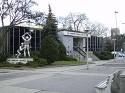
Hamilton, Ontario's culture has built on its historical and social background. Some attractions include a museum of aircraft, HMCS Haida National Historic Site, historic naval ship; Canada's most famous warship and the last remaining Tribal Class in the world, a stately residence of a Prime Minister of Upper Canada, a functioning nuclear reactor at McMaster University, a horticultural haven, the Canadian Football Hall of Fame, African Lion Safari and Christ the King Cathedral.
This article describes the Economic History of Hamilton, Ontario.
Bay Street is a lower city arterial road in Hamilton, Ontario, Canada. It starts at Inglewood Drive, just South of Aberdeen Avenue, as a collector road with only two lanes, then eventually becomes a six lane thoroughfare at its peak. Bay Street also passes through downtown Hamilton, where many high-rise buildings are found. Bay Street is a one-way street from Aberdeen Avenue to Cannon Street West. Bay Street continues as an arterial route to Strachan Street, where it is downgraded to a neighbourhood collector and eventually ends at a curb at Pier 4 Park at Burlington Street in the city's North End.
Burlington Street is a partially at grade and elevated roadway in Hamilton, Ontario, stretching along the south shore of Hamilton Harbour in Lake Ontario. Burlington Street has four different statuses along the route. In its western terminus, it is a collector route ending at Bay Street North. Upon the intersection at Wellington Street, the road becomes an arterial route with four lanes. The Street ends at Parkdale Avenue. On October 14, 2015, city council approved the renaming of the upper portion of Burlington Street from 165 meters east of Ottawa St to the QEW to Nikola Tesla Boulevard.
James Street is a Lower City arterial road in Hamilton, Ontario, Canada. It starts off at the base of the Niagara Escarpment from James Mountain Road, a mountain-access road in the city. It was one of many arterials in the central business district converted to one-way operation in 1956 when the city retained Wilbur Smith and Associates to develop a Traffic and Transportation Plan. Parts of it were restored to two-way operation in 2002. It extends north to the city's waterfront at the North End where it ends at Guise Street West right in front of the Harbour West Marina Complex and the Royal Hamilton Yacht Club.
Catharine Street is a Lower City collector road in Hamilton, Ontario, Canada. It starts off at Charlton Avenue East at Woolverton Park in the Corktown neighbourhood as a one-way street (southbound), tunnels underneath the Hunter Street Railway bridge and stretches up to Barton Street East where it then turns two-way and cutoff by the CN Railway lines that cut through Strachan Street Park one block north past Barton. Catharine Street then resumes again on Strachan Street East, north of the Park again as a two-way road for 3 blocks and interrupted again at Picton Street East, the site of St. Lawrence Elementary School and resumes again north of this property on Macauley Street East, again as a two-way street for another 3 blocks where it's interrupted for a third time at Brock Street, the site of Eastwood Park and Eastwood Arena. Catherine Street resumes again north of Eastwood Park on Guise Street East and ends at the city's North End waterfront, the site of a Royal Canadian Navy base and Pier 9.
Wentworth Street is a Lower City arterial road in Hamilton, Ontario, Canada. It starts off at the base of the Niagara Escarpment (mountain) on Charlton Avenue East just south of the CP lines and runs right through the city's North End industrial neighbourhood and ends north of Burlington Street East at Pier 14, which one time was used by International Harvester (1902–1992).
Ottawa Street is a Lower City arterial road in Hamilton, Ontario, Canada. It starts off at Lawrence Road at the base of the Niagara Escarpment (mountain) and is a two-way street throughout, cutting through the Delta and Crown Point neighbourhoods and the City's North End industrial neighbourhood. It ends at Industrial Drive, the site of the Dofasco steel company. This used to be one of the east ends' mountain access roads - it continued south over the train tracks at Lawrence Road and quickly turned right towards the brick manufacturing plant once known as Hamilton Brick. It took several turns before joining what is now the Kenilworth Access near the old water reservoir entrance. Its routing up the mountain is fairly consistent with the current Kenilworth Access with one exception - another hair-pin turn at the top; not the traffic circle that is present now. It was because of these hair-pin turns that the Hamilton Street Railway discontinued bus service on this road in 1944, and why the City planned a new Kenilworth Access to the east which opened in 1957.
King Street is a Lower City arterial road in Hamilton, Ontario, Canada, also known as Highway 8. The western-end starts off beside McMaster University Medical Centre as a two-way street and passes through Westdale. At Paradise Road, King Street switches over to a one-way street (westbound) right through the city's core up to "the Delta", a spot in town where King and Main streets intersect. From the Delta onwards, King Street then switches over to become a two-way street again and ends at Highway 8 in Stoney Creek.
York Boulevard is a Lower City arterial road in Hamilton, Ontario, Canada. Formerly known as Highway 2 and Highway 6, it starts in Burlington, Ontario, at Plains Road West as a two-way arterial road that wraps around and over Hamilton Harbour, enters the city of Hamilton in the west end at Dundurn Park, and ends at James Street North. It has a one-way section from Queen Street to Bay Street North, and continues east of James Street North as Wilson Street.)
Beach Boulevard is a Lower city street in Hamilton, Ontario, Canada, east of the Hamilton Harbour on a thin piece of land that crosses over Lake Ontario and stretches from where Woodward Avenue becomes Eastport Drive in the south to near the Lift Bridge in the north at Eastport Drive (again). It runs parallel with the QEW and the Burlington Bay James N. Allan Skyway Bridge.
The Pigott Building is an 18-storey condominium building located at 36 James Street South in downtown Hamilton, Ontario, Canada. This Art Deco/Gothic Revival style building was designed by Hamilton architects Bernard and Fred Prack and is designated under the Ontario Heritage Act.
{{cite book}}
: CS1 maint: multiple names: authors list (link){{cite web}}
: CS1 maint: unfit URL (link){{cite book}}
: CS1 maint: location missing publisher (link){{cite web}}
: CS1 maint: unfit URL (link){{cite web}}
: CS1 maint: unfit URL (link)