Ottawa Street (Hamilton, Ontario)

Last updated
OttawaStreetHamiltonA.JPG

Ottawa Street is a Lower City arterial road in Hamilton, Ontario, Canada. It starts off at Lawrence Road at the base of the Niagara Escarpment (mountain) and is a two-way street throughout, cutting through the Delta and Crown Point neighbourhoods and the City's North End industrial neighbourhood. It ends at Industrial Drive, the site of the Dofasco steel company. This used to be one of the east ends' mountain access roads - it continued south over the train tracks at Lawrence Road and quickly turned right towards the brick manufacturing plant once known as Hamilton Brick. It took several turns before joining what is now the Kenilworth Access near the old water reservoir entrance. Its routing up the mountain is fairly consistent with the current Kenilworth Access with one exception - another hair-pin turn at the top; not the traffic circle that is present now. It was because of these hair-pin turns that the Hamilton Street Railway discontinued bus service on this road in 1944, and why the City planned a new Kenilworth Access to the east which opened in 1957.

Contents

History

Laidlaw United Church, Ottawa Street South OttawaSHamiltonB.JPG
Laidlaw United Church, Ottawa Street South
Ottawa Street North, Textile district OttawaNHamiltonB.JPG
Ottawa Street North, Textile district
Ottawa Street North, Shopping district OttawaNHamiltonA.JPG
Ottawa Street North, Shopping district

In 1862, The city had invested in the Great Western Railway but the government of Canada favoured the rival Grand Trunk Railway. Also, after the end of the Depression (1857–1862), the population dips downwards in Hamilton and the city could not meet the interest on its bonds, many of which were held by British investors. To save the city from its creditors temporarily, Henry Beasley removes the assessment rolls, thus preventing a levy of special tax. Foundries and machine shops associated with the Great Western Railway failed and several established wholesalers closed their accounts. Daniel C. Gunn's locomotive works went bankrupt, but the manufacturers of farm implements and stoves-the mainstays of iron foundries- were able to weather the crisis. Those owned by Dennis Moore and the Copp brothers endured, but their employees suffered wage cuts and layoffs. Canadian patent laws and the underemployed workers skilled in machinist trades lured an important new industrial enterprise from the U.S.A.- the manufacture of sewing machines by Richard Wanzer. From this development there evolved the ready-made clothing industry, which William Eli Sanford introduced locally. The Textile District evolved in East Hamilton, centered on Ottawa Street and boomed during the First and Second World Wars. [1]

In 1913, Procter & Gamble Manufacturing Company (based in Cincinnati, Ohio) purchased 7 acres (28,000 m2) of land and 2 acres (8,100 m2) of water on the south side of Burlington Street between Depew and Ottawa Streets. This event marked the beginning of Procter & Gamble's operations outside of the United States. [2] In 1914, construction started on the Procter & Gamble Hamilton plant, which cost $1 million and consisted of seven buildings: the Crisco building, the boiler house, the gas plant, the soap building, the hardening plant, the kettle and glycerin house, and the machine shop. [2] By 1915, Procter & Gamble officially opens Hamilton plant, employing 75 workers who made six different products. [2]

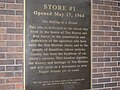
The Tim Hortons chain was founded in Hamilton in 1964. The original store still operates on Ottawa Street. [3] [4]

Centre Mall reconstruction project

Centre Mall owners announced plans for a 23-building super centre on the property on Barton Street East. Cost is estimated to be around $100-million and will take up 700,000 square feet (65,000 m2) of retail space. This will end up being the largest redevelopment project in the history of Hamilton's east-end. [5] The overhaul will take about two-and-a-half years to complete but the bulk of the work is expected to be done by the end of the summer of 2008. Some new buildings will go up before the enclosed mall is torn down. [6] The redevelopment of Centre Mall is transforming the entire neighbourhood from Ottawa to Kenilworth Avenue. The $100-million investment in the mall has boosted Ottawa Street North - already the city's No.1 tourist destination. The garment district has also morphed into a holistic home decor destination area, complete with lighting, antique, design & glass stores. The Ottawa Street B.I.A. had the most application and grants under the commercial property improvement program in 2007 with thirty three and it had an effect on the property values and real estate activity in the district. [6]

Landmarks

East Kiwanis Place, Ottawa Street North OttawaNHamiltonI.JPG
East Kiwanis Place, Ottawa Street North

Note: Listing of landmarks from north to south.

Major roads that cross Ottawa Street

Textile District, Ottawa Street North OttawaNHamiltonD.JPG
Textile District, Ottawa Street North

Note: Listing of streets from north to south.

Roads that are parallel with Ottawa Street

Textile District, Ottawa Street North OttawaNHamiltonE.JPG
Textile District, Ottawa Street North
Ottawa Street North, shopping district OttawaNHamiltonAA.JPG
Ottawa Street North, shopping district

Note: Listing of streets from west to east.

Images

See also

Related Research Articles

Economy of Hamilton, Ontario

This article is about the Economy of Hamilton, Ontario.

Economic history of Hamilton, Ontario

This article describes the Economic History of Hamilton, Ontario.

Burlington Street (Hamilton, Ontario) Road in Hamilton, Ontario, Canada

Burlington Street is a partially at grade and elevated roadway in Hamilton, Ontario, stretching along the south shore of Hamilton Harbour in Lake Ontario. Burlington Street has four different statuses along the route. In its western terminus, it is a collector route ending at Bay Street North. Upon the intersection at Wellington Street, the road becomes an arterial route with four lanes. The Street ends at Parkdale Avenue. On October 14, 2015, city council approved the renaming of the upper portion of Burlington Street from 165 meters east of Ottawa St to the QEW to Nikola Tesla Boulevard.

Wellington Street (Hamilton, Ontario)

Wellington Street is a Lower City arterial road in Hamilton, Ontario, Canada. It starts off at Charlton Avenue East as a two-way street for only one block where it's then blocked off by the Corktown Park and a couple of Canadian National Railway lines that cut through it. It then starts up again north of the park on Young Street and is a one-way street the rest of the way (Southbound). It ends in the North End of the City on Burlington Street East, in front of the Lakeport Brewing Company and the Administration offices of the Hamilton Port Authority.

Victoria Avenue (Hamilton, Ontario)

Victoria Avenue is a Lower City arterial road in Hamilton, Ontario, Canada. It starts off as a ramp and part of a Mountain-access road, the Claremont Access, on Hunter Street East in the Stinson neighbourhood. It's also a one-way thoroughfare that flows north through the Landsdale and the city's North End industrial neighbourhood past Burlington Street East where it ends at Pier 11.

Wentworth Street

Wentworth Street is a Lower City arterial road in Hamilton, Ontario, Canada. It starts off at the base of the Niagara Escarpment (mountain) on Charlton Avenue East just south of the CP lines and runs right through the city's North End industrial neighbourhood and ends north of Burlington Street East at Pier 14, which one time was used by International Harvester (1902–1992).

Sherman Avenue (Hamilton, Ontario)

Sherman Avenue is a collector road in the lower portion of Hamilton, Ontario, Canada. It begins at the Niagara Escarpment just south of Cumberland Avenue and is a one-way street bisecting the industrialized northern neighbourhoods of the city. It ends at Ship Street — the site of Steel Company of Canada (Stelco).

Gage Avenue (Hamilton, Ontario)

Gage Avenue is a Lower City arterial road in Hamilton, Ontario, Canada. It starts off at Lawrence Road at the base of the Niagara Escarpment (mountain) at the south end of Gage Park. It is a two-way arterial road that extends north through the city's North End industrial neighbourhood and ends at Industrial Drive.

Kenilworth Avenue (Hamilton, Ontario)

Kenilworth Avenue is a Lower City arterial road in Hamilton, Ontario, Canada. It starts off at the Kenilworth Traffic Circle and Kenilworth Access, a mountain-access road at the base of the Niagara Escarpment (mountain) and is a two-way street throughout stretching northward through the city's North End industrial neighbourhood where it then flows underneath the Burlington Street bridge and right into Dofasco's Industrial Park.

Parkdale Avenue (Hamilton, Ontario) Arterial road in Hamilton, Ontario Canada

Parkdale Avenue, is an arterial road in Hamilton, Ontario, Canada. It starts off just south of Lawrence Road at Hixon Road and is a two-way street throughout, stretching northward through the city's North End industrial neighbourhood and ends just north of the Nikola Tesla Boulevard East overpass at the front gates of Triple M Metal LP, a scrap & waste management company.

Nash Road is a Lower City street in Hamilton, Ontario, Canada. It starts off at King Street East in front of the Father Sean O'Sullivan Memorial Park and is a two-way collector road throughout that extends north to the Nashdale neighbourhood past Bancroft Street where it then hangs a right and turns into Brampton Street, a road that runs parallel with the northern portion of the Red Hill Valley Parkway and the Queen Elizabeth Expressway. After the 90 degree bend, the street signage labels the street as Nash Road where it intersects with Kenora Avenue, although all maps call that street Brampton Street. Nash Road then continues north of the QEW and ends shortly thereafter at Van Wagners Beach Road, the site of Confederation Park.

Barton Street (Hamilton, Ontario)

Barton Street is an arterial road in the Lower City of Hamilton, Ontario, Canada. It's also the longest street (21.0 km) in the city. It starts at the north end of downtown at Locke Street North and is a two-way street that stretches eastward through a number of different and varied communities in the city and ends in Winona at Fifty Road just west of the Hamilton/Niagara regional boundary. The street is divided in East and West portions, divided by James Street. However, the East designation does not continue through the Stoney Creek district, which was a separate municipality prior to amalgamation in 2001, and the designation as well as the address numbering system were not restructured upon amalgamation, and numbers reset at the former city limits at Centennial Parkway.

Cannon Street (Hamilton, Ontario)

Cannon Street, is a Lower City collector road in Hamilton, Ontario, Canada. It starts off at Queen Street North as a one-way street (Westbound) up to Sherman Avenue North where it then switches over to a two-way street the rest of the way Eastward and ends just past Kenilworth Avenue North on Barons Avenue and merges with Britannia Avenue, a street that runs parallel with Cannon Street from Ottawa Street North to Barons Avenue.

King William Street (Hamilton, Ontario)

King William Street is a Lower City collector road in Hamilton, Ontario, Canada. It starts off at the western-end at James Street North and is a one-way street (Eastbound) until Mary Street, where it becomes a two-way street that ends at Wentworth Street North. It is named after King William IV of the United Kingdom.

Main Street (Hamilton, Ontario)

Main Street is a street in Hamilton, Ontario, Canada.

Limeridge Road is a two-way Upper City (mountain) collector road in Hamilton, Ontario, Canada. It starts off just west of Garth Street/William McCulloch Park as Limeridge Court and cuts across the Hamilton mountain eastward running parallel with the Lincoln M. Alexander Parkway and ends at Mountain Brow Boulevard, South of Mohawk Sports Park in front of Upper King's Forest Park.

The Centre on Barton Shopping mall in Hamilton, Ontario

The Centre on Barton is an outdoor shopping centre in the Lower City of Hamilton, Ontario, Canada. The centre is located on Barton Street East bounded by Ottawa Street North in the western-end and Kenilworth Avenue North on the eastern-end. It was formerly known as the Centre Mall and before that, the Greater Hamilton Shopping Centre. It was a "plaza" for many years before being closed in as a "mall" and access to the stores was available through a front and back door of the plaza. In 2008, the mall was rebuilt back to an outdoor shopping centre.

Upper James Street (Hamilton, Ontario)

Upper James Street, is an Upper City (mountain) arterial road in Hamilton, Ontario, Canada. It starts at the Claremont Access, a mountain-access road in the north, and extends southward towards the John C. Munro Hamilton International Airport where it then changes its name to the Hamilton Port Dover Plank Road,. It is a two-way street throughout. As with most of the "Upper" streets, their addresses start at roughly the point where their lower counterpart finishes just below the Escarpment and were originally labelled without the "Upper" prefix.

Upper Sherman Avenue is an Upper City (mountain) arterial road in Hamilton, Ontario, Canada. It starts off north of Concession Street at Mountain Park Avenue and extends southward where it ends at Rymal Road. It is a two-way street throughout. As with most of the "Upper" streets, their addresses start at roughly the point where their lower counterpart finishes just below the Escarpment and were originally labelled without the "Upper" prefix.

Upper Paradise Road is an Upper City (mountain) collector road in Hamilton, Ontario, Canada. It starts off just north of Scenic Drive by Cliffview Park and extends southward where it ends just south of Rymal Road beside Carpenter Park. It is a two-way street throughout.

References

  1. Bailey, Thomas Melville (1981). Dictionary of Hamilton Biography (Vol I, 1791-1875). W.L. Griffin Ltd.
  2. 1 2 3 "History of Industry in Hamilton, Ontario". Archived from the original on 2006-02-06. Retrieved 2007-03-29.
  3. "Tim Horton's Biography: Ron Joyce". Archived from the original on 2007-04-16. Retrieved 2007-03-29.
  4. "Tim Hortons Official History" (PDF). Archived from the original (PDF) on 2007-03-15. Retrieved 2007-03-29.
  5. ""Centre Mall owners plan 23-building super centre."" (Press release). The Hamilton Spectator. 2007-09-27.
  6. 1 2 ""New lease on life for Ottawa St."" (Press release). The Hamilton Spectator, Lisa Grace Marr. 2007-11-24.