
Hamilton is an inland city in the North Island of New Zealand. Located on the banks of the Waikato River, it is the seat and most populous city of the Waikato region. With a territorial population of 185,300, it is the country's fourth most-populous city. Encompassing a land area of about 110 km2 (42 sq mi), Hamilton is part of the wider Hamilton Urban Area, which also encompasses the nearby towns of Ngāruawāhia, Te Awamutu and Cambridge. In 2020, Hamilton was awarded the title of most beautiful large city in New Zealand.

Hamilton is a town in the eastern central portion of Essex County in eastern Massachusetts, United States. At the 2020 census, it had a population of 7,561. Currently the town has no manufacturing industry and no industrially zoned land.

Burlington is a city in the Regional Municipality of Halton at the west end of Lake Ontario in Ontario, Canada. Located approximately halfway between Toronto and Niagara Falls, it is part of the Greater Toronto and Hamilton Area and Hamilton metropolitan census area.
A regional municipality is a type of Canadian municipal government similar to and at the same municipal government level as a county, although the specific structure and servicing responsibilities may vary from place to place. Regional municipalities were formed in highly populated areas where it was considered more efficient to provide certain services, such as water, emergency services, and waste management over an area encompassing more than one local municipality. For this reason, regions may be involved in providing services to residents and businesses.

The Regional Municipality of Hamilton–Wentworth was an upper-tier regional municipality in Ontario, Canada, that existed between January 1, 1974, and January 1, 2001. It was composed of six municipalities, centered on and including the City of Hamilton, and existed to coordinate certain shared services, such as policing and public transit, for those municipalities. It was created through the restructuring of Wentworth County, and was one of the last such governments to be created in Ontario.

The Hamilton Street Railway (HSR) is the public transport agency for Hamilton, Ontario. The name is a legacy of the company's early period, when public transit in Hamilton was primarily served by streetcars. Although streetcars are no longer used in the city today, the HSR operates bus and paratransit services, with a ridership of 21 million passengers a year.

Stoney Creek is a community in the city of Hamilton in the Canadian province of Ontario. It was officially a city from 1984 to 2001, when it was amalgamated with the rest of the cities of the Regional Municipality of Hamilton–Wentworth.
Lincoln was a federal electoral district represented in the House of Commons of Canada from 1867 to 1883 and from 1904 to 1997. It was on the Niagara Peninsula in the Canadian province of Ontario. At various times, there was also an electoral district of the same name used in provincial elections.

A county highway is a road in the United States and in the Canadian province of Ontario that is designated and/or maintained by the county highway department. Route numbering can be determined by each county alone, by mutual agreement among counties, or by a statewide pattern.

The Lincoln Alexander Parkway, nicknamed The Linc, is a municipal expressway in the city of Hamilton, Ontario, Canada, which connects Highway 403 with the Red Hill Valley Parkway, which continues north to the Queen Elizabeth Way (QEW). Collectively, the two expressways form a southern and eastern bypass of Hamilton. Located on the Hamilton mountain, atop the Niagara Escarpment, the freeway was named after the former Progressive Conservative MP and first black Lieutenant Governor of Ontario, Lincoln Alexander in July 1997, despite him never holding a driver's license.
King's Highway 20, commonly referred to as Highway 20, is a provincially maintained highway in the Canadian province of Ontario. Presently, it is a short 1.9 km (1.2 mi) stub between Highway 58 and Niagara Regional Road 70 in the City of Thorold, but until 1997 it connected Hamilton to Niagara Falls, serving several towns atop the Niagara Escarpment en route.

The 1988 Hamilton municipal election was held on November 14, 1988 to elect a Regional Chairman, a Mayor, sixteen members to Hamilton, Ontario City Council, seventeen members to the Hamilton Board of Education and thirteen members to the Hamilton-Wentworth Roman Catholic Separate School Board.
King's Highway 8, commonly referred to as Highway 8, is a provincially maintained highway in the Canadian province of Ontario. The 159.7-kilometre (99.2 mi) route travels from Highway 21 in Goderich, on the shores of Lake Huron, to Highway 5 in the outskirts of Hamilton near Lake Ontario. Before the 1970s, it continued east through Hamilton and along the edge of the Niagara Escarpment to the American border at the Whirlpool Bridge in Niagara Falls. However, the Queen Elizabeth Way (QEW) replaced the role of Highway 8 between those two cities, and the highway was subsequently transferred from the province to the newly formed Regional Municipality of Niagara in 1970. In 1998, the remaining portion east of Peters Corners was transferred to the city of Hamilton.
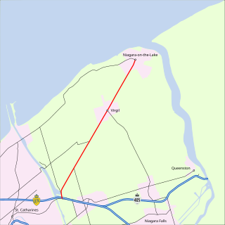
King's Highway 55, commonly referred to as Highway 55 and historically as the Niagara Stone Road and Black Swamp Road, was a provincially maintained highway in the Canadian province of Ontario, which connected the Queen Elizabeth Way (QEW) with Niagara-on-the-Lake, following Niagara Stone Road. The route divided a swath of wineries at the foot of the Niagara Escarpment, passing at an oblique angle to the concession road grid.

Barton Street is an arterial road in the Lower City of Hamilton, Ontario, Canada. It's also the longest street (21.0 km) in the city. It starts at the north end of downtown at Locke Street North and is a two-way street that stretches eastward through a number of different and varied communities in the city and ends in Winona at Fifty Road just west of the Hamilton/Niagara regional boundary. The street is divided in East and West portions, divided by James Street. However, the East designation does not continue through the Stoney Creek district, which was a separate municipality prior to amalgamation in 2001, and the designation as well as the address numbering system were not restructured upon amalgamation, and numbers reset at the former city limits at Centennial Parkway.
King's Highway 52, commonly referred to as Highway 52, was a provincially maintained highway located in the former Regional Municipality of Hamilton-Wentworth, now the City of Hamilton. The route began at a junction with former Highway 2 and Highway 53 near Ancaster and travelled north to Highway 5 and Highway 8 in Peters Corners. An older section travelled concurrently with Highway 8 northwest to Rockton, where it turned north and travelled to the Hamilton–Wellington boundary, ending inexplicably at a township road.
King's Highway 53, commonly referred to as Highway 53, was a provincially maintained highway in the southern portion of the Canadian province of Ontario that connected Woodstock to Hamilton via Brantford. The 76.5-kilometre (47.5 mi) route served as a southerly bypass to Highway 2, avoiding Paris, Ancaster and Hamilton. In addition to the previously mentioned cities, Highway 53 served the communities of Cathcart and Burford.

In South Africa some roads are designated as numbered routes to help with navigation. There is a nationwide numbering scheme consisting of national, provincial and regional routes, and within various urban areas there are schemes of metropolitan route numbering.