For civic-addressing purposes (such as 911), nearly all rural roads in Perth County are numbered. Roads that run east and west, or southeast and northwest, are numbered "Line 1", "Line 2", and so on to "Line 93". Roads that run north and south, or northeast and southwest, are numbered "Road 101", "Road 102", and so on to "Road 183". The roads maintained by the County are numbered in accordance with this scheme; for example, "Perth Line 9" is the section of Line 9 that the county maintains, and "Perth Road 151" is the section of Road 151 that the county maintains.
King's Highway 33, commonly referred to as Highway 33 or Loyalist Parkway, is a provincially maintained highway in the Canadian province of Ontario. The route begins at Highway 62 in Bloomfield and travels east to the Collins Bay Road junction at Collins Bay in the city of Kingston, a distance of 60.9 kilometres (37.8 mi). The highway continues farther east into Kingston as Bath Road, ending at the former Highway 2, now Princess Street. Highway 33 is divided into two sections by the Bay of Quinte. The Glenora Ferry service crosses between the two sections just east of Picton, transporting vehicles and pedestrians for free throughout the year.
Route 440 is a state highway in New Jersey, United States. It comprises two segments, a 5.15-mile (8.29 km) freeway in Middlesex County linking Interstate 287 (I-287) and the New Jersey Turnpike (I-95), in Edison to the Outerbridge Crossing in Perth Amboy and a 8.18-mile (13.16 km) four-lane divided highway in Hudson County running from the Bayonne Bridge in Bayonne to U.S. Route 1/9 Truck in Jersey City. These two segments are connected by New York State Route 440 (NY 440), which runs across Staten Island. The freeway portion in Middlesex County is six lanes wide and interchanges with the Garden State Parkway and US 9 in Woodbridge.
King's Highway 7, commonly referred to as Highway 7 and historically as the Northern Highway, is a provincially maintained highway in the Canadian province of Ontario. At its peak, Highway 7 measured 716 km (445 mi) in length, stretching from Highway 40 east of Sarnia in Southwestern Ontario to Highway 17 west of Ottawa in Eastern Ontario. However, due in part to the construction of Highways 402 and 407, the province transferred the sections of Highway 7 west of London and through the Greater Toronto Area to county and regional jurisdiction. The highway is now 535.7 km (332.9 mi) long; the western segment begins at Highway 4 north of London and extends 154.1 km (95.8 mi) to Georgetown, while the eastern segment begins at Donald Cousens Parkway in Markham and extends 381.6 km (237.1 mi) to Highway 417 in Ottawa.
A county highway is a road in the United States and in the Canadian province of Ontario that is designated and/or maintained by the county highway department. Route numbering can be determined by each county alone, by mutual agreement among counties, or by a statewide pattern.
King's Highway 50, commonly referred to as Highway 50, was a provincially maintained highway in the Canadian province of Ontario. The highway, which was decommissioned in 1998, is still referred to as Highway 50, though it is now made up of several county and regional roads: Peel Regional Road 50, York Regional Road 24 and Simcoe County Road 50. The route began in the north end corner of the former Etobicoke at Highway 27 as Albion Road, and travelled northwest to Highway 89 west of the town of Alliston. En route, it passed through the villages of Bolton, Palgrave and Loretto. The road south of Bolton is becoming increasingly suburban as development encroaches from the east and west; but despite this increasing urbanization, the removal of highway status, and the fact that it runs through the former Albion Township, the Albion Road name has not been extended to follow it outside Toronto.
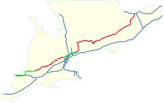
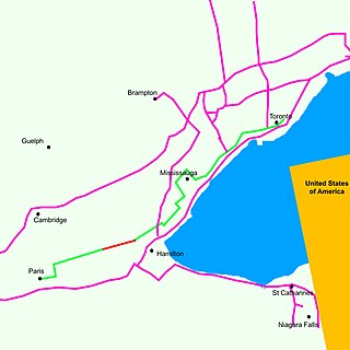
King's Highway 5, commonly referred to as Highway 5 and historically as the Dundas Highway, is a provincially maintained highway in the Canadian province of Ontario. The east–west highway travels a distance of 12.7 km (7.9 mi) between Highway 8 at Peter's Corners, north of Hamilton, and Highway 6 at Clappison's Corners. Prior to several sections being downloaded to the municipalities in which they are located, Highway 5 served as bypass to Highway 2, connecting with it in both Paris and Toronto, a distance of 114.3 km (71.0 mi).
Secondary Highway 502, commonly referred to as Highway 502, is a provincially maintained secondary highway in the Canadian province of Ontario. The highway is 151.7 kilometres (94.3 mi) long, connecting Highway 11 east of Fort Frances with Highway 17 in Dryden, via Highway 594. It also carries the Great River Road designation.
King's Highway 15, commonly referred to as Highway 15, is a provincially maintained highway in the Canadian province of Ontario. It currently travels north from an interchange with Highway 401 in Kingston to Highway 7 in Carleton Place, but once continued east from there into Ottawa until that section became part of Highway 7. The length of Highway 15 is 113.4 kilometres (70.5 mi).
King's Highway 19, commonly referred to as Highway 19, is a provincially maintained highway in the Canadian province of Ontario, connecting Highway 3 in Tillsonburg with Highway 401 southeast of Ingersoll. The highway began as the Plank and Gravel Road, a toll road formed by the Ingersoll and Port Burwell Road Company. It was first assigned in 1930. Several extensions in the early 1930s took the route north to Highway 86 at Tralee. However, a significant amount of Highway 19 was decommissioned and turned over to local and county governments in 1997 and 1998.
King's Highway 23, commonly referred to as Highway 23, is a provincially maintained highway in the Canadian province of Ontario. The route travels from Highway 7 east of Elginfield north to Highway 9 and Highway 89 in Harriston. The total length of Highway 23 is 97.7 kilometres. The highway was first established in 1927 between Highway 8 in Mitchell and Highway 9 in Teviotdale, via Monkton, Listowel and Palmerston. As part of a depression relief program, it was extended south to Highway 7 in 1934. It remained relatively unchanged until 2003, when it was rerouted northward from Palmerston to Harriston.
King's Highway 136, commonly referred to as Highway 136, was a provincially maintained highway in the Canadian province of Ontario that connected former Highway 24 near Caledon with Highway 9 in Orangeville. The majority of the route was located in the Regional Municipality of Peel; however, the section in Orangeville was in Dufferin County. The route of Highway 136 was originally part of Highway 24; it was created in 1962 when Highway 24 was rerouted along Highway 51. The highway remained unchanged until 1997, when it was transferred to the Regional Municipality of Peel and the Town of Orangeville.
King's Highway 38, commonly referred to as Highway 38, was a provincially maintained highway in the Canadian province of Ontario. The road connected Highway 2 and Highway 401 in Kingston with Highway 7 west of Perth. It was designated in 1934 and remained relatively unchanged throughout its existence, aside from some minor diversions and a rerouting through Kingston as a result of the construction of Highway 401 in the mid-1950s. At the beginning of 1998, the entire highway was transferred to the municipalities of Frontenac County through which it travelled: Kingston, South Frontenac and Central Frontenac. Today the former highway is named Road 38 and Gardiners Road, but is still referred to as Highway 38 by locals.
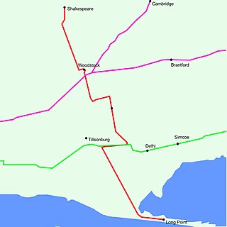
King's Highway 59, commonly referred to as Highway 59, was a provincially maintained highway in the Canadian province of Ontario. It connected Long Point Provincial Park in Norfolk County to the town of Shakespeare in Perth County, passing through the city of Woodstock in Oxford County en route. Several smaller towns also lined the highway, notably Courtland, Delhi, Norwich and Tavistock. Highway 59 featured junctions with Highway 3, Highway 2, Norfolk County Highway 24 and the concurrent routes of Highway 7 and Highway 8. Highway 59 also had an interchange with Highway 401.
King's Highway 43, also known as Highway 43, was a provincially maintained highway in the Canadian province of Ontario. On January 1, 1998, the entire route was transferred to the county that each section resided in, resulting in the current designations of Lanark County Road 43, Leeds and Grenville Road 43 and Stormont, Dundas and Glengarry Road 43. Highway 43 ran somewhat parallel to and between Highway 401 and Highway 417 from Highway 7 in Perth to Highway 34 in Alexandria, passing through several small towns along the way. At 154.2 km (95.8 mi), it is the longest highway in Ontario to be decommissioned entirely during the mass transfer of Highways in 1997 and 1998.
King's Highway 83, also known as Highway 83, was a provincially maintained highway in the Canadian province of Ontario. The route travelled inwards from the shores of Lake Huron, beginning at Highway 21 north of Grand Bend and travelling eastward to Highway 23 in Russeldale. Today the route is known by the local names Dashwood Road and Thames Road, as well as by county-assigned designations Huron County Road 83 and Perth County Road 20.
King's Highway 30, commonly referred to as Highway 30, was a provincially maintained highway in the Canadian province of Ontario. The 51.1-kilometre (31.8 mi)-long route connected Highway 2 in Brighton with Highway 7 in Havelock via Campbellford. Established in 1930, the highway initially travelled only as far north as Campbellford. Alongside the construction of Highway 7 between Peterborough and Perth, Highway 30 was extended north to Havelock in 1934. The route remained generally consistent until 1998, when it was decommissioned and transferred to Northumberland County and Peterborough County. Both counties redesignated their portion of the former highway as County Road 30.
This page is based on this Wikipedia article Text is available under the CC BY-SA 4.0 license; additional terms may apply. Images, videos and audio are available under their respective licenses.