
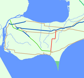
King's Highway 401, commonly referred to as Highway 401 and also known by its official name as the Macdonald–Cartier Freeway or colloquially referred to as the four-oh-one, is a controlled-access 400-series highway in the Canadian province of Ontario. It stretches 828 kilometres (514 mi) from Windsor in the west to the Ontario–Quebec border in the east. The part of Highway 401 that passes through Toronto is North America's busiest highway, and one of the widest. Together with Quebec Autoroute 20, it forms the road transportation backbone of the Quebec City–Windsor Corridor, along which over half of Canada's population resides. It is also a Core Route in the National Highway System of Canada. The route is maintained by the Ministry of Transportation of Ontario (MTO) and patrolled by the Ontario Provincial Police. The speed limit is 100 km/h (62 mph) throughout its length, with the only exceptions the posted 80 km/h (50 mph) limit westbound in Windsor and in most construction zones.

Oxford County is a regional municipality in the Canadian province of Ontario. Highway 401 runs east–west through the centre of the county, creating an urban industrial corridor with more than half the county's population, spanning 25 km between the Toyota auto assembly plant in Woodstock and the CAMI General Motors auto assembly plant in Ingersoll. The local economy is otherwise dominated by agriculture, especially the dairy industry.

King's Highway 416, commonly referred to as Highway 416 and as the Veterans Memorial Highway, is a 400-series highway in the Canadian province of Ontario that connects the Trans-Canada Highway (Highway 417) in Ottawa with Highway 401 between Brockville and Cornwall. The 76.4-kilometre-long (47.5 mi) freeway acts as an important trade corridor from Interstate 81 between New York and Eastern Ontario via Highway 401, as well as the fastest link between Ottawa and Toronto. Highway 416 passes through a largely rural area, except near its northern terminus where it enters the suburbs of Ottawa. The freeway also serves several communities along its length, notably Spencerville and Kemptville.
King's Highway 60, commonly referred to as Highway 60, is a provincially maintained highway in the Canadian province of Ontario. The 255.8-kilometre (158.9 mi) highway serves as the primary corridor through Algonquin Provincial Park, where it is dedicated as the Frank McDougall Parkway. East of Algonquin Park, the route serves east–west traffic in the highlands of central Ontario. It begins at Highway 11 in Huntsville and ends at Highway 17 near Renfrew.
MOM's Way is the name for a series of highways in the Canadian provinces of Ontario and Manitoba, and the U.S. state of Minnesota. The name "MOM" is an acronym for Manitoba, Ontario, and Minnesota, the two provinces and one state traversed by this multi-highway route. MOM's Way provides a secondary route between the cities of Winnipeg, Manitoba and Thunder Bay, Ontario. Many segments of MOM's Way are connected to the Old Dawson Trail, the first all-Canadian route between Thunder Bay and Winnipeg.
King's Highway 400A, once known as the Highway 400 Extension, was an unsigned 400-series highway in the Canadian province of Ontario. The short 1.1-kilometre (0.7 mi) freeway link connected Highway 400 with Highway 11 and Simcoe County Road 93, formerly Highway 93. The highway was created in late 1959 by the opening of Highway 400 to Coldwater, although it has always featured Highway 400 signage in the southbound direction and Highway 11 signage northbound.

King's Highway 93, commonly referred to as Highway 93, is a provincially maintained highway in the Canadian province of Ontario. Located entirely within Simcoe County, the highway extends 23.9 kilometres (14.9 mi) from an interchange with Highway 400 in Springwater, just south of the community of Hillsdale, to an intersection with Highway 12 at the town limits of Midland. The route follows the historic Penetanguishene Road, an early colonization road which served to connect Lake Simcoe with Georgian Bay, thus providing an overland route from Lake Huron to Lake Ontario via Yonge Street.
Pennsylvania Route 10 is a 44.04-mile-long (70.88 km) state route in southeastern Pennsylvania. Its southern terminus is at PA 472 in Oxford. Its northern terminus is at U.S. Route 222 Business in Reading. PA 10 is mostly a two-lane undivided road that serves Chester, Lancaster, and Berks counties. The route begins in Oxford and passes through rural areas of western Chester County, serving Cochranville, Parkesburg, Compass, and Honey Brook. The route passes through a small corner of Lancaster County before it enters Berks County and reaches Morgantown, where it has interchanges with Interstate 176 (I-176) and the Pennsylvania Turnpike (I-76). Between Morgantown and Reading, PA 10 parallels I-176.
The Veterans Memorial Parkway is a 9.2 km (5.7 mi) expressway located in London, Ontario. The expressway was previously known as King's Highway 100 from 1977 until 1994 and as Airport Road from 1977 to September 2006. It is currently an at-grade, four-lane expressway. Long term plans / proposals for the route include north and south extensions of the road and grade separated interchanges along its entire length, converting it to a freeway.
King's Highway 35, also known as Highway 35, is a provincial highway in the Canadian province of Ontario, linking Highway 401 with Peterborough, Kawartha Lakes, and Algonquin Park. The highway travels from west of Newcastle, through Lindsay and the Kawarthas and into Haliburton before terminating at Highway 60 to the west of Algonquin Park. The winding course of the highway, combined with the picturesque views offered along its length, have led some to declare it the most scenic highway in Ontario.
King's Highway 77, commonly referred to as Highway 77, is a provincially maintained highway in the Canadian province of Ontario. One of three highways within Essex County, Highway 77 serves to interconnect Highway 3 near Leamington with Highway 401 near Tilbury. Prior to 1998, the highway extended south into Leamington, ending at the former routing of Highway 3 and Highway 18. This section was turned over to Essex County and renamed Erie Street. The speed limit on Highway 77 is 80 km/h (50 mph) in most places, dropping to 50 km/h in built-up areas. It is patrolled by the Ontario Provincial Police.
King's Highway 19, commonly referred to as Highway 19, is a provincially maintained highway in the Canadian province of Ontario, connecting Highway 3 in Tillsonburg with Highway 401 southeast of Ingersoll. The highway began as the Plank and Gravel Road, a toll road formed by the Ingersoll and Port Burwell Road Company. It was first assigned in 1930. Several extensions in the early 1930s took the route north to Highway 86 at Tralee. However, a significant amount of Highway 19 was decommissioned and turned over to local and county governments in 1997 and 1998.

Elgin—Middlesex—London is a provincial electoral district in southwestern Ontario, Canada. It elects one member to the Legislative Assembly of Ontario.
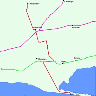
King's Highway 59, commonly referred to as Highway 59, was a provincially maintained highway in the Canadian province of Ontario. It connected Long Point Provincial Park in Norfolk County to the town of Shakespeare in Perth County, passing through the city of Woodstock in Oxford County en route. Several smaller towns also lined the highway, notably Courtland, Delhi, Norwich and Tavistock. Highway 59 featured junctions with Highway 3, Highway 2, Norfolk County Highway 24 and the concurrent routes of Highway 7 and Highway 8. Highway 59 also had an interchange with Highway 401.
Kawartha Lakes Road 35, also known as Victoria Road and Fennel Road, is a municipally-maintained road located in the city of Kawartha Lakes, in the Canadian province of Ontario. The road is mostly straight, running in a north–south orientation throughout its length. It began at the hamlet of Glenarm and travels 30.5 kilometres (19.0 mi) to Uphill.
King's Highway 30, commonly referred to as Highway 30, was a provincially maintained highway in the Canadian province of Ontario. The 51.1-kilometre (31.8 mi)-long route connected Highway 2 in Brighton with Highway 7 in Havelock via Campbellford. Established in 1930, the highway initially travelled only as far north as Campbellford. Alongside the construction of Highway 7 between Peterborough and Perth, Highway 30 was extended north to Havelock in 1934. The route remained generally consistent until 1998, when it was decommissioned and transferred to Northumberland County and Peterborough County. Both counties redesignated their portion of the former highway as County Road 30.
King's Highway 45, commonly referred to as Highway 45, was a provincially maintained highway in the Canadian province of Ontario. The 54.1-kilometre-long (33.6 mi) route connected Highway 2 in downtown Cobourg with Highway 7 in Norwood. In addition to the towns at either end, it bisected the communities of Baltimore, Fenella, Alderville, Roseneath and Hastings.