Related Research Articles
Grey County is a county of the Canadian province of Ontario. The county seat is in Owen Sound. It is located in the subregion of Southern Ontario named Southwestern Ontario. Grey County is also a part of the Georgian Triangle. At the time of the Canada 2016 Census the population of the county was 93,830.

A county highway is a road in the United States and in the Canadian province of Ontario that is designated and/or maintained by the county highway department. Route numbering can be determined by each county alone, by mutual agreement among counties, or by a statewide pattern.
King's Highway 24, commonly referred to as Highway 24, is a highway in the Canadian province of Ontario that currently begins at Highway 3 in Simcoe, and ends at the southern city limits of Cambridge. The south–north route travels through Brantford, as well as the community of Scotland. Outside of those communities, Highway 24 travels through a predominantly agricultural area.

King's Highway 107, commonly referred to as Highway 107, was a provincially maintained highway in the Canadian province of Ontario situated midway between the towns of Kingsville and Leamington. The route was one of the shortest highways to exist in the province, at a length of 1.5 kilometres (0.93 mi). It has been through several re-numberings throughout its history but is now known as Essex County Road 45 or Union Avenue. The route began at Highway 18 and travelled north to Highway 3 at Ruthven.
King's Highway 19, commonly referred to as Highway 19, is a provincially maintained highway in the Canadian province of Ontario, connecting Highway 3 in Tillsonburg with Highway 401 southeast of Ingersoll. The highway began as the Plank and Gravel Road, a toll road formed by the Ingersoll and Port Burwell Road Company. It was first assigned in 1930. Several extensions in the early 1930s took the route north to Highway 86 at Tralee. However, a significant amount of Highway 19 was decommissioned and turned over to local and county governments in 1997 and 1998.

Secondary Highway 503, commonly referred to as Highway 503, was a provincially maintained secondary highway in the Canadian province of Ontario. The 116.8 km (72.6 mi) route existed between 1956 and 1998. Between 1956 and 1963, the highway stretched from Kirkfield to Sebright, and then along the Monck Road from Sebright to Kinmount, entirely within Victoria County. In 1964, the route was extended to Highway 121 in Tory Hill along the route of Highway 500 through the counties of Peterborough and Haliburton. In 1998, the route was transferred to the various counties in which it resided. Today it is known as Kawartha Lakes City Road 6 and 45, Peterborough County Road 503 and Haliburton County Road 503.

King's Highway 90, commonly referred to as Highway 90, was a provincially maintained highway in the Canadian province of Ontario. The route connected Barrie with the town of Angus and CFB Borden. The highway was designated in 1937. During the early 1960s, the highway was realigned within Barrie in order to have it interchange with Highway 400; originally the route followed Tiffin Street. At the beginning of 1998, the entire highway was transferred to the City of Barrie and Simcoe County; it is now known as Simcoe County Road 90.
King's Highway 73, commonly referred to as Highway 73, was a provincially maintained highway in the Canadian province of Ontario. The route began in Port Bruce and progressed north through Aylmer, encountering Highway 401 immediately before terminating east of Dorchester. The route was established in mid-1937, remaining unchanged for nearly six decades before being transferred to Elgin County and Middlesex County in 1997 and 1998. Today the route is known as Elgin County Road 73 and Middlesex County Road 73.
King's Highway 95, commonly referred to as Highway 95, was a provincially maintained highway in the Canadian province of Ontario on Wolfe Island. Together with Highway 96, the routes were the only King's Highways not connected to the rest of the network by a fixed link. At its southern end, the 11.4-kilometre (7.1 mi) route connected to New York State Route 12E via the private and seasonal Horne's Ferry. At its northern end, it connected with Highway 96 in Marysville a short distance west of the MV Wolfe Islander III ferry to Kingston. Today it is under the jurisdiction of Frontenac Islands Township, as Frontenac County does not have a county road system.
King's Highway 96, commonly referred to as Highway 96, was a provincially maintained highway in the Canadian province of Ontario on Wolfe Island and the main street of Marysville, the island's main village. Together with Highway 95, the routes were the only King's Highway not connected to the rest of the network by a fixed link. Today it is under the jurisdiction of Frontenac Islands Township as Frontenac County does not have a county road system.
King's Highway 81, also known as Highway 81, was a provincially maintained highway in the Canadian province of Ontario. The winding north–south route connected Highway 2 in Delaware with Highway 21 in Grand Bend, passing through Mount Brydges, Strathroy and Parkhill en route. Highway 81 was first designated in 1936 and extended in 1937, and retained generally the same route throughout its existence until it was transferred to the responsibility of Middlesex County and Huron County in 1997 and 1998. Today the entire route is known as Middlesex County Road 81 and Huron County Road 81.
King's Highway 91, commonly referred to as Highway 91, was a provincially maintained highway in the Canadian province of Ontario that connected Highway 24 south of Collingwood with Highway 26 in Stayner, a distance of 7.9 km (4.9 mi). The majority of the route travels through farmland, with the exception of the portion within Stayner. Highway 91 was established in mid 1937 along an existing road. Aside from paving in 1965, the highway remained unchanged until it was decommissioned at the beginning of 1998 and transferred to Simcoe County. Today the route is officially known as Simcoe County Road 91.
King's Highway 45, commonly referred to as Highway 45, was a provincially maintained highway in the Canadian province of Ontario. The 54.1-kilometre-long (33.6 mi) route connected Highway 2 in downtown Cobourg with Highway 7 in Norwood. In addition to the towns at either end, it bisected the communities of Baltimore, Fenella, Alderville, Roseneath and Hastings.
King's Highway 74, commonly referred to as Highway 74, was a provincially maintained highway in the Canadian province of Ontario that travelled north from Highway 3 at New Sarum to Middlesex County Road 29 on the outskirts of London. The 22.4-kilometre-long (13.9 mi) was assumed by the province in September 1937. Aside from paving and the construction of an interchange with Highway 401, it remained generally unchanged for the next six decades until it was decommissioned in 1997 and transferred to Elgin County and Middlesex County. The road has since been redesignated as Elgin County Road 74 and Middlsex County Road 74.
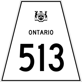
Secondary Highway 513, commonly referred to as Highway 513, was a provincially maintained secondary highway in the Canadian province of Ontario. Located within Renfrew County, the highway travelled northward from Highway 132 at Dacre along Scotch Bush Road, turning eastward on what is now Renfrew County Road 22, and ending a short distance to the east before reaching Douglas.
References
- Official Road Map of Southern Ontario, Ontario Ministry of Transportation