List of numbered roads in Kingston and Frontenac County

Last updated

This is a list of numbered municipal roads in Kingston and Frontenac County, Ontario .

The City of Kingston is a single-tier municipality not under the jurisdiction of an upper-tier municipality such as Frontenac County and thus, is outside of the geographic limits of Frontenac County for municipal purposes. For geographic purposes however, Kingston is within the geographic limits of Frontenac County. [1] The City of Kingston forms part of the county's census division.

The numbered roads in this list are not under the jurisdiction of Frontenac County (only their numbers are, for coordination[ citation needed ]); the responsibility for their maintenance is with the individual townships (and City of Kingston). [2] As a result, the "flowerpot" municipal road shields are signed with the name of the township, such as Central Frontenac, Kingston or Wolfe Island (for Frontenac Islands Township). South Frontenac Township makes reference to its numbered township highways as Township Road n in law. [3]

Main List

Route(s) [3] Name [3] West/South Terminus [3] East/North Terminus [3] CommunitiesComments
Kingston City Road 1.svg
Kingston Road 1
Front RoadLemoine PointKing Street WestKingston
Kingston City Road 2.svg
Princess Street
Highway 2
KingstonFormerly Highway 2
Kingston Road 3
Unity RoadRR 11 jct.svg Kingston Road 11Elginburg, Glenburnie
South Frontenac Township Road 4.svg
South Frontenac Township Road 4
Yarker RoadRR 38 jct.svg Township Road 38
South Frontenac Township Road 5.svg
South Frontenac Township Road 5
Harrowsmith Road Harrowsmith
South Frontenac Township Road 7.svg
South Frontenac Township Road 7
Bellrock RoadRR 38 jct.svg Township Road 38Verona
South Frontenac Township Road 8.svg
South Frontenac Township Road 8
WestportGodfrey, Fermoy
Kingston City Road 9.svg
Kingston Road 9

South Frontenac Township Road 9.svg
South Frontenac Township Road 9
Sydenham RoadPrincess StreetKingston, Sydenham
Kingston City Road 10.svg
Kingston Road 10

South Frontenac Township Road 10.svg
South Frontenac Township Road 10
Division Street
Perth Road
Kingston, Westport
Kingston City Road 11.svg
Kingston Road 11

South Frontenac Township Road 11.svg
South Frontenac Township Road 11
Battersea RoadKingston, BatterseaContinues as Montreal Street in Kingston.
Kingston City Road 12.svg
Kingston Road 12

South Frontenac Township Road 12.svg
South Frontenac Township Road 12
Ontario 15 crown.svg Highway 15
Kingston City Road 13.svg
Kingston Road 13
Continues as RR 13 jct.svg County Road 13Ontario 15 crown.svg Highway 15
Kingston City Road 15.svg
Highway 15Ontario 2 crown.svg  Highway 2 Ontario 401 crown.svg Highway 401 KingstonContinues as Highway 15
Kingston City Road 16.svg
Kingston Road 16
Joyceville RoadOntario 2 crown.svg  Highway 2 Ontario 15 crown.svg  Highway 15 Joyceville
Kingston City Road 17.svg
Kingston Road 17
Days RoadFront RoadBath RoadKingston
South Frontenac Township Road 18.svg
South Frontenac Township Road 18
Wilton RoadHarrowsmith
South Frontenac Township Road 19.svg
South Frontenac Township Road 19
Canoe Lake RoadFermoy
Kingston City Road 23.svg
Kingston Road 23
Taylor-Kidd BoulevardKingston
Kingston City Road 25.svg
Kingston Road 25
Bayridge DriveKingston
Kingston City Road 33.svg
Bath RoadPrincess StreetKingstonFormerly Highway 33; part of Loyalist Parkway
Kingston City Road 38.svg
Kingston Road 38

South Frontenac Township Road 38.svg
South Frontenac Township Road 38

Central Frontenac Township Road 38.svg
Central Frontenac Township Road 38
Gardiners RoadBath RoadOntario 7 crown.svg Highway 7 Kingston, Verona, Sharbot Lake Formerly Highway 38
Frontenac Islands Township Road 95
Highway 95Wolfe Island Ferry Dock, Marysville Point AlexandriaMarysville, Wolfe Island Formerly Highway 95
Frontenac Islands Township Road 96
Highway 96Sand Bay RoadPort MetcalfScotch Settlement, Wolfe Island Formerly Highway 96
North Frontenac Township Road 506
Road 506Ontario 41 crown.svg Highway 41 North Frontenac Road 509Formerly Highway 506
Central Frontenac Township Road 509.svg
Central Frontenac Township Road 509

North Frontenac Township Road 509
Road 509Ontario 7 crown.svg Highway 7 North Frontenac Road 506Clarendon, Snow Road, OmpahFormerly Highway 509

Related Research Articles

A civil township is a widely used unit of local government in the United States that is subordinate to a county, most often in the northern and midwestern parts of the country. The term town is used in New England, New York, as well as Wisconsin to refer to the equivalent of the civil township in these states; Minnesota uses "town" officially but often uses it and "township" interchangeably. Specific responsibilities and the degree of autonomy vary in each state. Civil townships are distinct from survey townships, but in states that have both, the boundaries often coincide and may completely geographically subdivide a county. The U.S. Census Bureau classifies civil townships as minor civil divisions. Currently, there are 20 states with civil townships.

<span class="mw-page-title-main">Hastings County</span> County in Ontario, Canada

Hastings County is located in the province of Ontario, Canada. Geographically, it is located on the border of Eastern Ontario and Central Ontario. Hastings County is the second-largest county in Ontario, after Renfrew County, and its county seat is Belleville, which is independent of Hastings County. Hastings County has trademarked the moniker "Cheese Capital of Canada".

<span class="mw-page-title-main">Simcoe County</span> County in Ontario, Canada

Simcoe County is located in the central portion of Southern Ontario, Canada. The county is just north of the Greater Toronto Area, stretching from the shores of Lake Simcoe in the east to Georgian Bay in the west. Simcoe County forms part of the Greater Golden Horseshoe area, a densely populated and industrialized region, centred on the Greater Toronto Area.

<span class="mw-page-title-main">Frontenac County</span> County in Ontario, Canada

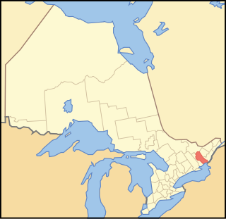
Frontenac County is a county and census division of the Canadian province of Ontario. It is located in the eastern portion of Southern Ontario. The city of Kingston is in the Frontenac census division, but is separated from the County of Frontenac.

<span class="mw-page-title-main">South Frontenac</span> Township in Ontario, Canada

South Frontenac is a township in Frontenac County in eastern Ontario, Canada. It was amalgamated in 1998 from the former townships of Bedford, Loughborough, Portland, and Storrington.

<span class="mw-page-title-main">Loyalist, Ontario</span> Township municipality in Ontario, Canada

Loyalist is a lower-tier township municipality in central eastern Ontario, Canada on Lake Ontario. It is in Lennox and Addington County and consists of two parts: the mainland and Amherst Island. It was named for the United Empire Loyalists, who settled in the area after the American Revolution.

<span class="mw-page-title-main">County highway</span> Type of highway

A county highway is a road in the United States and in the Canadian province of Ontario that is designated and/or maintained by the county highway department. Route numbering can be determined by each county alone, by mutual agreement among counties, or by a statewide pattern.

<span class="mw-page-title-main">Kingston and the Islands (federal electoral district)</span> Federal electoral district in Ontario, Canada

Kingston and the Islands is a federal electoral district in Ontario, Canada, that has been represented in the House of Commons of Canada since 1968.

<span class="mw-page-title-main">Portland, Ontario</span> Police Village in Ontario, Canada

Portland is a police village and unincorporated place located in the municipal township of Rideau Lakes, United Counties of Leeds and Grenville in eastern Ontario, Canada. The community is on Ontario Highway 15 about 60 kilometres (37 mi) northeast of Ontario Highway 401 at Kingston by road, and is situated in geographic Bastard Township on the southeast side of Big Rideau Lake.

<span class="mw-page-title-main">Midland District, Upper Canada</span>

Midland District was one of four districts of the Province of Quebec created in 1788 in the western reaches of the Montreal District and partitioned in 1791 to create the new colony of Upper Canada.

King's Highway 38, commonly referred to as Highway 38, was a provincially maintained highway in the Canadian province of Ontario. The 66.9-kilometre (41.6 mi) road connected Highway 2 and Highway 401 in Kingston with Highway 7 west of Perth. It was designated in 1934 and remained relatively unchanged throughout its existence, aside from some minor diversions and a rerouting through Kingston as a result of the construction of Highway 401 in the mid-1950s. At the beginning of 1998, the entire highway was transferred to the municipalities of Frontenac County through which it travelled: Kingston, South Frontenac and Central Frontenac. Today the former highway is named Road 38 and Gardiners Road, but is still referred to as Highway 38 by locals.

King's Highway 95, commonly referred to as Highway 95, was a provincially maintained highway in the Canadian province of Ontario on Wolfe Island. Together with Highway 96, the routes were the only King's Highways not connected to the rest of the network by a fixed link. At its southern end, the 11.4-kilometre (7.1 mi) route connected to New York State Route 12E via the private and seasonal Horne's Ferry. At its northern end, it connected with Highway 96 in Marysville a short distance west of the MV Wolfe Islander III ferry to Kingston. Today it is under the jurisdiction of Frontenac Islands Township, as Frontenac County does not have a county road system.

King's Highway 96, commonly referred to as Highway 96, was a provincially maintained highway in the Canadian province of Ontario on Wolfe Island and the main street of Marysville, the island's main village. Together with Highway 95, the routes were the only King's Highway not connected to the rest of the network by a fixed link. Today it is under the jurisdiction of Frontenac Islands Township as Frontenac County does not have a county road system.

<span class="mw-page-title-main">Millhaven Creek</span> River in Ontario, Canada

Millhaven Creek is a stream in the municipalities of Loyalist, Lennox and Addington County, and South Frontenac, Frontenac County, and the single-tier municipality of Kingston in eastern Ontario, Canada. It is a tributary of Lake Ontario and is under the auspices of the Cataraqui Region Conservation Authority.
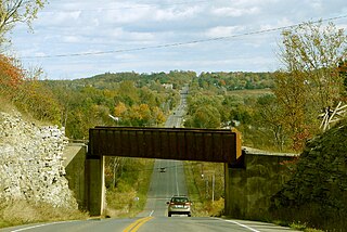
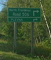
References

  1. O. Reg. 180/03: DIVISION OF ONTARIO INTO GEOGRAPHIC AREAS, s. 2, Government of Ontario, retrieved 2020-06-24
  2. Roads and Bridges, County of Frontenac, archived from the original on 2019-04-23, retrieved 2019-04-23
  3. 1 2 3 4 5 The Corporation of the Township of South Frontenac, By-Law 2000-01 (PDF), archived from the original (PDF) on 2019-06-30, retrieved 2019-06-30