
The counties of Ireland are historic administrative divisions of the island. They began as Norman structures, and as the powers exercised by the Cambro-Norman barons and the Old English nobility waned over time, new offices of political control came to be established at a county level. The number of counties varied depending on the time period, however thirty-two is the traditionally accepted and used number.

Long Island is a populous island east of Manhattan in southeastern New York state, constituting a significant share of the New York metropolitan area in both population and land area. The island extends from New York Harbor 118 miles (190 km) eastward into the North Atlantic Ocean with a maximum north–south width of 23 miles (37 km). With a land area of 1,401 square miles (3,630 km2), it is the largest island in the contiguous United States.
Nevada is a landlocked state in the Western region of the United States. It borders Oregon to the northwest, Idaho to the northeast, California to the west, Arizona to the southeast, and Utah to the east. Nevada is the 7th-most extensive, the 32nd-most populous, and the 9th-least densely populated of the U.S. states. Nearly three-quarters of Nevada's people live in Clark County, which contains the Las Vegas–Paradise metropolitan area, including three of the state's four largest incorporated cities. Nevada's capital is Carson City. Las Vegas is the largest city in the state.

New Jersey is a state in both the Mid-Atlantic and Northeastern regions of the United States. It is the most densely populated state and at the center of the Northeast megalopolis. New Jersey is bordered on its north and east by New York state; on its east, southeast, and south by the Atlantic Ocean; on its west by the Delaware River and Pennsylvania; and on its southwest by Delaware Bay and Delaware. At 7,354 square miles (19,050 km2), New Jersey is the fifth-smallest state in land area, but with close to 9.3 million residents as of the 2020 United States census, it ranks 11th in population. The state capital is Trenton, and the state's most populous city is Newark. New Jersey is the only U.S. state in which every county is deemed urban by the U.S. Census Bureau.

Orange County is a county located in the Los Angeles metropolitan area in Southern California, United States. As of the 2020 census, the population was 3,186,989, making it the third-most-populous county in California, the sixth-most-populous in the United States, and more populous than 19 American states and Washington, D.C. Although largely suburban, it is the second-most-densely-populated county in the state behind San Francisco County. The county's three most-populous cities are Anaheim, Santa Ana, and Irvine, each of which has a population exceeding 300,000. Santa Ana is also the county seat. Six cities in Orange County are on the Pacific coast: Seal Beach, Huntington Beach, Newport Beach, Laguna Beach, Dana Point, and San Clemente.

Lancashire is a ceremonial county in North West England. It is bordered by Cumbria to the north, North Yorkshire and West Yorkshire to the east, Greater Manchester and Merseyside to the south, and the Irish Sea to the west.
A county seat is an administrative center, seat of government, or capital city of a county or civil parish. The term is in use in five countries: Canada, China, Hungary, Romania, and the United States. An equivalent term, shire town, is used in the U.S. state of Vermont and in several other English-speaking jurisdictions.
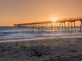
Southern California is a geographic and cultural region that generally comprises the southern portion of the U.S. state of California. It includes the Los Angeles metropolitan area as well as the Inland Empire. The region generally contains ten of California's 58 counties: Los Angeles, San Diego, Orange, Riverside, San Bernardino, Kern, Ventura, Santa Barbara, San Luis Obispo, and Imperial counties.
In the United States, a metropolitan statistical area (MSA) is a geographical region with a relatively high population density at its core and close economic ties throughout the region. Such regions are not legally incorporated as a city or town would be and are not legal administrative divisions like counties or separate entities such as states. As a result, sometimes the precise definition of a given metropolitan area will vary between sources. The statistical criteria for a standard metropolitan area were defined in 1949 and redefined as a metropolitan statistical area in 1983.

Los Angeles County, officially the County of Los Angeles, and sometimes abbreviated as L.A. County, is the most populous county in the United States, with 9,861,224 residents estimated in 2022. Its population is greater than that of 40 individual U.S. states. Comprising 88 incorporated cities and many unincorporated areas within a total area of 4,083 square miles (10,570 km2), it is home to more than a quarter of Californians and is one of the most ethnically diverse U.S. counties. The county's seat, Los Angeles, is the second most populous city in the United States, with 3,822,238 residents estimated in 2022. The county has been world-renowned as the domicile of the U.S. motion-picture industry since the latter's inception in the early 20th century.
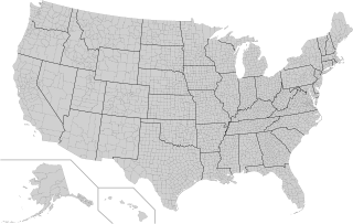
In the United States, a county or county equivalent is an administrative or political subdivision of a U.S. state or other territories of the United States which consists of a geographic area with specific boundaries and usually some level of governmental authority. The term "county" is used in 48 states, while Louisiana and Alaska have functionally equivalent subdivisions called parishes and boroughs, respectively. The specific governmental powers of counties vary widely between the states, with many providing some level of services to civil townships, municipalities, and unincorporated areas. Certain municipalities are in multiple counties; New York City is uniquely partitioned into five counties, referred to at the city government level as boroughs. Some municipalities have been consolidated with their county government to form consolidated city-counties, or have been legally separated from counties altogether to form independent cities. Conversely, counties in Connecticut and Rhode Island, eight of Massachusetts's 14 counties, and Alaska's Unorganized Borough have no government power, existing only as geographic distinctions.

Barrow County is a county located in the north central portion of the U.S. state of Georgia. As of the 2020 census, its population was 83,505. Its county seat is Winder. Barrow County is included in the Atlanta–Sandy Springs–Roswell metropolitan statistical area.

Winder is a city and the county seat of Barrow County, Georgia, United States. It is located east of Atlanta and is part of the Atlanta metropolitan area. The population was 18,338 at the 2020 census.

An unincorporated area is a region that is not governed by a local municipal corporation. There are many unincorporated communities and areas in the United States and Canada.
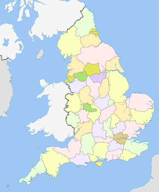
The counties of England are a type of subdivision of England. Counties have been used as administrative areas in England since Anglo-Saxon times. There are three definitions of county in England: the 48 ceremonial counties used for the purposes of lieutenancy; the 84 metropolitan and non-metropolitan counties for local government; and the 39 historic counties which were used for administration until 1974.

Ceremonial counties, formally known as counties for the purposes of the lieutenancies, are areas of England to which lord-lieutenants are appointed. They are one of the two main legal definitions of the counties of England in modern usage, the other being the counties for the purposes of local government legislation. A lord-lieutenant is the monarch's representative in an area. Shrieval counties have the same boundaries and serve a similar purpose, being the areas to which high sheriffs are appointed. High sheriffs are the monarch's judicial representative in an area.

Stockport County Football Club is a professional association football club based in Stockport, Greater Manchester, England. The team competes in EFL League One, the third tier of the English football league system, after winning the 2023–24 EFL League Two title.

The boroughs of New York City are the five major governmental districts that compose New York City. The boroughs are the Bronx, Brooklyn, Manhattan, Queens, and Staten Island. Each borough is coextensive with a respective county of the State of New York: The Bronx is Bronx County, Brooklyn is Kings County, Manhattan is New York County, Queens is Queens County, and Staten Island is Richmond County.


