Egmondville, Ontario

Last updated

Egmondville
Unincorporated rural community
Van Egmond Residence - Egmondville, ON.jpg
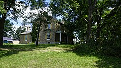
The Van Egmond Residence
Canada Ontario location map 2.svg
Red pog.svg
Egmondville
Location in Ontario
Canada location map 2.svg
Red pog.svg
Egmondville
Egmondville (Canada)
Coordinates: 43°32′41″N81°24′11″W / 43.54472°N 81.40306°W / 43.54472; -81.40306
Country Canada
Province Ontario
County Huron
Municipality Huron East
Time zone UTC-5 (Eastern (EST))
  Summer (DST) UTC-4 (EDT)
GNBC CodeFEHQG [1]

Egmondville is an unincorporated rural community in Huron East, Huron County, Ontario, Canada. [1] [2]

Contents

History

The community was founded in 1845 by Constant Van Egmond, the eldest son of Anthony Van Egmond and named in honour of his father. Van Edmonds and son Constant were contracted in the 1830s to widen Huron Road and became the largest landowners in the area. Constant Van Egmond became a local magistrate. [3]

See also

Related Research Articles

<span class="mw-page-title-main">Stratford, Ontario</span> City in Ontario, Canada

Stratford is a city on the Avon River within Perth County in southwestern Ontario, Canada, with a 2021 population of 33,232 in a land area of 30.02 square kilometres (11.59 sq mi). Stratford is the seat of Perth County, which was settled by English, Irish, Scottish and German immigrants, in almost equal numbers, starting in the 1820s but primarily in the 1830s and 1840s. Most became farmers; even today, the area around Stratford is known for mixed farming, dairying and hog production.

<span class="mw-page-title-main">Canada Company</span> British land development company

The Canada Company was a private British land development company that was established to aid in the colonization of a large part of Upper Canada. It was incorporated by royal charter on August 19, 1826, under an act of the British parliament, which was given royal assent on June 27, 1825. It was originally formed to acquire and develop Upper Canada's undeveloped clergy reserves and Crown reserves, which the company bought in 1827 for £341,000 ($693,000) from the Province of Upper Canada.

<span class="mw-page-title-main">Seaforth, Ontario</span> Unincorporated community in Ontario, Canada

Seaforth is a Southern Ontario community in the municipality of Huron East, in Huron County, Ontario, Canada.

Anthony Van Egmond was purportedly a Dutch Napoleonic War veteran. He became one of the first settlers and business people in the Huron Tract in present-day southwestern Ontario Canada. Van Egmond became an early contractor employed by the Canada Company to construct the original 74-kilometre (46 mi) road into the new settlement, allowing the entry of settlers for the purchase of company lands and further economic development. He eventually became a supporter of William Lyon Mackenzie and led a force of armed rebels in their unsuccessful skirmish at Montgomery's Tavern near Toronto on 7 December 1837, during the Upper Canada Rebellion.

<span class="mw-page-title-main">Wingham, Ontario</span> Community in Ontario, Canada

Wingham is a community located in the municipality of North Huron, Ontario, Canada, which is located in Huron County. Wingham became part of North Huron in 2001 when the Ontario government imposed amalgamation on the former township of East Wawanosh, the village of Blyth, and the town of Wingham.

<span class="mw-page-title-main">Perth County, Ontario</span> County in Ontario, Canada

Perth County is a county in the Canadian province of Ontario in Southwestern Ontario, 100 kilometres (62 mi) west of Toronto. Its population centres are Listowel, Mitchell and Milverton. The City of Stratford and the Town of St. Marys are within the Perth census division, but are separate from Perth County. The 2016 population of Perth County was 38,066.

<span class="mw-page-title-main">Vanastra, Ontario</span> Dispersed rural community in Ontario, Canada

Vanastra is a dispersed rural community and unincorporated place in the municipality of Huron East, Huron County in southwestern Ontario, Canada, 3 kilometres (1.9 mi) southeast of the community of Clinton. It is located on the former property of a top secret Royal Canadian Air Force (RCAF) station used to train and supply over 7,000 radar technicians and support staff for American, British and Canadian forces during World War II.

<span class="mw-page-title-main">Tara, Ontario</span> Community in Ontario, Canada

Tara is an unincorporated community in the municipality of Arran–Elderslie, Bruce County, in southwestern Ontario, Canada. It is a designated place and had 1,037 residents and 458 dwellings as of the 2011 census. Tara is in geographic Arran Township and is located on the Sauble River. It has an area of 2.39 square kilometres (0.92 sq mi) and an urban area that covers 63.5 square kilometres (24.5 sq mi).

<span class="mw-page-title-main">Mitchell, Ontario</span>

<span class="mw-page-title-main">Perth East, Ontario</span> Township in Ontario, Canada

The Township of Perth East is a municipality in Perth County, Ontario, Canada and situated north of Stratford. It was created in 1998 when the Ontario government amalgamated the village of Milverton with the surrounding former townships of Ellice, Mornington, North Easthope and South Easthope.

<span class="mw-page-title-main">Ashfield–Colborne–Wawanosh</span> Township in Ontario, Canada

The Township of Ashfield–Colborne–Wawanosh is a municipality in Huron County, Ontario, Canada. It was formed as an amalgamation of the former Ashfield, Colborne and West Wawanosh townships in 2001, in an Ontario-wide local government restructuring imposed by the government of that time. The three former townships now comprise the wards of the amalgamated municipality. Mayor of Dungannon Robert Brindley Jr.

<span class="mw-page-title-main">North Huron, Ontario</span> Township in Ontario, Canada

The Township of North Huron is a municipality in Huron County, Ontario, Canada. It was formed in 2001 when the Ontario government imposed amalgamation on municipalities throughout the province. Specifically, the former township of East Wawanosh was merged with the village of Blyth and the town of Wingham.

King's Highway 8, commonly referred to as Highway 8, is a provincially maintained highway in the Canadian province of Ontario. The 159.7-kilometre (99.2 mi) route travels from Highway 21 in Goderich, on the shores of Lake Huron, to Highway 5 in the outskirts of Hamilton near Lake Ontario. Before the 1970s, it continued east through Hamilton and along the edge of the Niagara Escarpment to the American border at the Whirlpool Bridge in Niagara Falls. However, the Queen Elizabeth Way (QEW) replaced the role of Highway 8 between those two cities, and the highway was subsequently transferred from the province to the newly formed Regional Municipality of Niagara in 1970. In 1998, the remaining portion east of Peters Corners was transferred to the city of Hamilton.

<span class="mw-page-title-main">Port Franks, Ontario</span> Place in Ontario, Canada

Port Franks is a small Southern Ontario community in the municipality of Lambton Shores, Lambton County in southwestern Ontario, Canada. It is located along Kings Highway 21 near Pinery Provincial Park, about 8 kilometres (5.0 mi) north of Thedford, Ontario. Archaeological evidence suggests that human habitation and use of this site date back thousands of years, and that locally obtained flint was manufactured at the so-called 'flint chipping beds' in the vicinity long before the period of European contact with First Nations peoples in the Great Lakes Basin.

King's Highway 19, commonly referred to as Highway 19, is a provincially maintained highway in the Canadian province of Ontario, connecting Highway 3 in Tillsonburg with Highway 401 southeast of Ingersoll. The highway began as the Plank and Gravel Road, a toll road formed by the Ingersoll and Port Burwell Road Company. It was first assigned in 1930. Several extensions in the early 1930s took the route north to Highway 86 at Tralee. However, a significant amount of Highway 19 was decommissioned and turned over to local and county governments in 1997 and 1998.

<span class="mw-page-title-main">Bayfield, Ontario</span> Place in Ontario, Canada

Bayfield is a community in the municipality of Bluewater, Huron County in southwestern Ontario, Canada with a 2016 population of 1,112. Bluewater Municipality includes Bayfield, Bruce field, Dashwood, Hensall, Varna, and Zurich This municipality is made up of 92.8% English speaking people, 6.3% of other language speaking people and 0.9% of French speaking people as of 2016. In addition to this the majority of Bayfield's population is made up of Canadians, creating 88.2% of the population in the year 2016. It is on the eastern shore of Lake Huron at the mouth of Bayfield River. Bayfield is a popular tourist destination. Visitors enjoy the historic Main Street with its many well-preserved old buildings, including the Little Inn which has served travelers since the 1800s, initially as a stagecoach stop. Main Street is lined with boutique shops, art galleries and fine dining restaurants. The nearby marina and public beaches draw crowds in the summer months.

Storey and Van Egmond was an architectural partnership in Regina, Saskatchewan, Canada, that functioned from 1907 to 1924. Initially, the principals were Edgar M. Storey (1863-1913) and William Gysbert Van Egmond (1883-1949).

Silver Creek is a river in the municipality of Huron East, Huron County, Ontario, Canada and a right tributary of the Bayfield River.

<span class="mw-page-title-main">Huron Tract</span> Area of land in Ontario, Canada

The Huron Tract Purchase also known as the Huron Block, registered as Crown Treaty Number 29, is a large area of land in southwestern Ontario bordering on Lake Huron to the west and Lake Erie to the east. The area spans the counties of Huron, Perth, Middlesex and present day Lambton County, Ontario in the province of Ontario.

The Wellington, Grey and Bruce Railway (WG&BR) was a railway in Ontario, Canada. It ran roughly northwest from Guelph to the port town of Southampton on Lake Huron, a distance of 101 miles (163 km). It also had a 66-mile (106 km) branch line splitting off at Palmerston and running roughly westward to Kincardine, another port town. A branch running south from Southampton was built during the construction of the Bruce Nuclear Generating Station in the 1970s.

References

  1. 1 2 "Egmondville". Natural Resources Canada. October 6, 2016.
  2. "Huron East". Statistics Canada. November 2, 2016.
  3. "Van Egmond Residence". Canada's Historic Places. Retrieved April 27, 2019.

Sources