Jamestown often refers to:

Brussels is a community in Huron County, Ontario, Canada, located within the municipality of Huron East. It was originally called Ainleyville. The name was changed in 1872 when a branch line of the Grand Trunk Railway from Guelph came through the town. Brussels has seen the population grow over the years, in 1954, the population was 827.

Seaforth is a Southern Ontario community in the municipality of Huron East, in Huron County, Ontario, Canada.
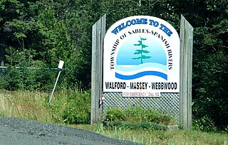
Sables-Spanish Rivers is a township in Ontario, Canada, on the north shore of Georgian Bay. It is located in the Sudbury District, approximately 70 kilometres (43 mi) west of Sudbury.

Mount Forest is an unincorporated community located at the junction of Highway 6 and Highway 89 in the township of Wellington North, Ontario, Canada. The town's motto is "High, Healthy, Happy", which can be seen on the water tower when approaching the town from the south. As of the 2011 Canadian census the population of Mount Forest was 4,757.

Grey County is a county of the Canadian province of Ontario. The county seat is in Owen Sound. It is located in the subregion of Southern Ontario named Southwestern Ontario. Grey County is also a part of the Georgian Triangle. At the time of the Canada 2016 Census the population of the County was 93,830.
Bosanquet is a former township of Lambton County in Ontario, Canada located northeast of Sarnia.
Wentworth County, area 269,057 acres (1,089 km2), is a historic county in the Canadian province of Ontario.

Markdale is a community in the Municipality of Grey Highlands, in Grey County, Ontario, Canada. The population was 1,216 in 2016, an increase of 3.5% from 1,175 in 2011. In 2016, the average age of the population was approximately 43 years old.

Dashwood is a small, primarily residential, community in southwestern Ontario, Canada. The former police village is located at the intersection of Bronson Line and Dashwood Road, on the boundary between the Municipality of Bluewater and the Municipality of South Huron. The community is situated approximately 50 kilometers north west of London near the resort village of Grand Bend, which is located on the south east coast of Lake Huron.
Harriston is a community in the Town of Minto in Wellington County, Ontario, Canada. In 1999, Harriston was amalgamated with the communities of Palmerston, Clifford, and Minto Township to form the Town of Minto. Harriston is located at the headwaters of the Maitland River, and has several shops, restaurants, a library, an art gallery and cultural centre.

Arkona is a community located in the municipality of Lambton Shores in southwestern Ontario near the Lambton–Middlesex county line, situated beside the Ausable River, on Former Kings Highway 79, Arkona is roughly halfway between Thedford, and Watford.
Whitby Township is a geographic township and former municipality in what was Ontario County, Ontario, Canada. It is now part of the Town of Whitby.
Langstaff is a residential community straddling Richmond Hill and Markham, in Ontario, Canada. Located near Highway 7 and Yonge Street, the homes in the area date to the 1960s and 1970s. The East Don River and CN Rail Bala subdivision runs through the community.
Saltford is a small unincorporated community in Ontario, Canada, located at the intersection of Highway 21 and Saltford Road, on the east bank of the Maitland River in the township of Ashfield-Colborne-Wawanosh just east of Goderich. In early 1866, local entrepreneur Samuel Platt discovered the presence of brine while drilling for oil in the community. He subsequently developed a salt extraction business, using an evaporation process. This discovery inspired the development of several salt extraction operations in the immediate area, eventually culminating in the opening of the Sifto Salt mine in nearby Goderich, currently (2007) the third largest salt producer in the world.

Jamestown Township is one of twelve townships in Steuben County, Indiana, United States. As of the 2010 census, its population was 3,249 and it contained 2,937 housing units.
Ethel is a hamlet located in northern Huron County, Ontario, Canada and has a population of nearly two hundred. It is in the municipality of Huron East in Grey Township. Ethel is home to the Grey Township Fire Department, the Ethel Community Hall, the former Ethel United Church, Ethel Mennonite Church, the Ethel Ball Park and North Woods Elementary School.

Wroxeter, Ontario is a community in Howick Township, part of Huron County.
Holmesville is a community in the Canadian province of Ontario, in the township of Central Huron, fourteen kilometres southeast of Goderich. Founded in 1832 by two Irish Canadian immigrants named Samuel and John Holmes, the community was first called Holmes Hill and Holmes Villa before receiving its current name of Holmesville in 1855. It has a population of approximately 910 people. (2017)
Cranbrook is a community and unincorporated area in the municipality of Huron East, Huron County in southwestern Ontario, Canada, It is located at the intersection of McNabb Line and Cranbrook Road in geographic Grey Township.
