
The Au Sable River in Michigan, United States runs approximately 138 miles (222 km) through the northern Lower Peninsula, through the towns of Grayling and Mio, and enters Lake Huron at Au Sable. It is considered one of the best brown trout fisheries east of the Rockies and has been designated a blue ribbon trout stream by the Michigan Department of Natural Resources. In French, au sable literally means "at the sand." A 1795 map calls it the Beauais River.

Bloomfield Township is a civil township of Huron County in the U.S. state of Michigan. As of the 2000 census, the township population was 535.

Huron Township is a civil township of Huron County in the U.S. state of Michigan. The population was 423 at the 2000 census.
Sherman Township is a civil township of Huron County in the U.S. state of Michigan. The population was 1,165 at the 2000 census.

Seaforth is a Southern Ontario community in the municipality of Huron East, in Huron County, Ontario, Canada.

The Maitland River is a river in Huron County, Perth County and Wellington County in Southwestern Ontario, Canada. The river is in the Great Lakes Basin and empties into Lake Huron at the town of Goderich. It is 150 kilometres (93 mi) long, and is named after Sir Peregrine Maitland, Lieutenant-Governor of Upper Canada from 1818 to 1828. It was formerly known as the Menesetung River.

Huron—Bruce is a federal electoral district in Ontario, Canada, that has been represented in the House of Commons of Canada since 1953.
White Rock is a tiny unincorporated community of Sherman Township at the southeast corner of Huron County in the U.S. state of Michigan. The community is at the mouth of White Rock Creek on the shore of Lake Huron. The community is at 43°42′35″N82°36′31″W, about three miles north of Forestville and about nine miles south of Harbor Beach on M-25 at the junction with White Rock Road.

Dashwood is a small, primarily residential, community in southwestern Ontario, Canada. The former police village is located at the intersection of Bronson Line and Dashwood Road, on the boundary between the Municipality of Bluewater and the Municipality of South Huron. The community is situated approximately 50 kilometers north west of London near the resort village of Grand Bend, which is located on the south east coast of Lake Huron.

Blyth is a village in North Huron, Huron County, Ontario, Canada.
The Township of Ashfield-Colborne-Wawanosh is a municipality in Huron County, Ontario, Canada. It was formed as an amalgamation of the former Ashfield, Colborne and West Wawanosh townships in 2001, in an Ontario-wide local government restructuring imposed by the government of that time. The three former townships now comprise the wards of the amalgamated municipality.
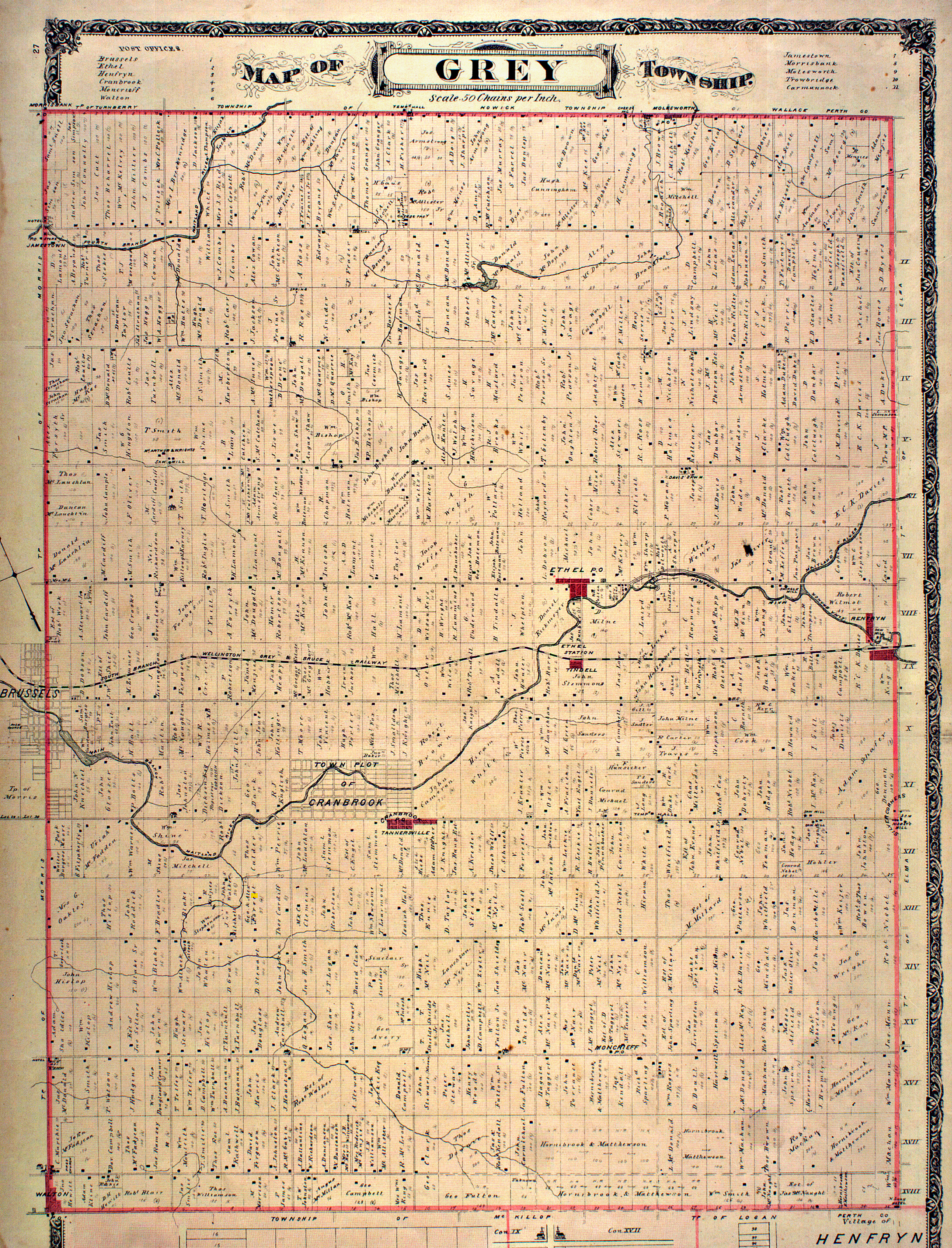
The Municipality of Huron East is a Canadian municipality located in Huron County, Ontario. It was formed in 2001 as an amalgamation of the former Grey, McKillop and Tuckersmith townships with the town of Seaforth and village of Brussels, due to an Ontario-wide local government restructuring imposed by the government of that time. The new municipality is structured as five wards based on the former townships, town and village.
Brunner is a community in the Township of Perth East, Perth County, Ontario, Canada. It lies 17 kilometres (11 mi) north of Stratford on Perth County Road 119. Topping is the nearest community, 4 kilometres (2 mi) east, and Milverton is 5 kilometres (3 mi) north. The Stratford and Huron Railway, later part of Canadian National Railway, passes through the community.
Spidertown was a small, agricultural supply and services based community in southwestern Ontario, Canada that existed in the last half of the 19th and the early 20th century. The site of the former hamlet is located at the present intersection of Mount Carmel Drive, Blackbush Line and Salem Road, on the boundary between the current municipality of North Middlesex and the municipality of South Huron. Little is currently known of Spidertown's founding, nor the origin of its name. The hamlet is described in one source as consisting, at one point in time, of "taverns on both corners" and "four homes". It is known, that in the latter 19th century a general store was operated in the community by Alexander Todd, presumably the same individual who operated two other general stores during the period at Maguire and Moray as well. A medical doctor, T. L. Flaherty, maintained a practice in a corner house in the hamlet in the latter 19th century, but is known to have moved his office to Mount Carmel, 2 kilometers (1.2 mi) to the east, before 1898. It is believed that Spidertown began to go into decline because of its inability to compete economically with the nearby hamlet of Mount Carmel. Spidertown is recorded as having disappeared by 1914.

Mount Carmel is a primarily residential hamlet located in southwestern Ontario, Canada.
Ethel is a hamlet located in northern Huron County, Ontario, Canada and has a population of nearly two hundred. It is in the municipality of Huron East in Grey Township. Ethel is home to the Grey Township Fire Department, the Ethel Community Hall, the former Ethel United Church, Ethel Mennonite Church, the Ethel Ball Park and North Woods Elementary School.

Wroxeter, Ontario is a community in Howick Township, part of Huron County.

Sunnybrook is a hamlet in central Alberta, Canada within Leduc County. It is located on Highway 39, approximately 43 kilometres (27 mi) west of Leduc.
Jamestown is a community in Ontario, Canada.
Wallbridge is an unorganized geographic township in Parry Sound District, Ontario, Canada. Part of the census subdivision of Unorganized Centre Parry Sound District, the township includes the communities of Britt, Byng Inlet and Harris Lake and the rail sidings of Drocourt and North Magnetawan. Although not an incorporated municipality, Britt and Byng Inlet are jointly served by a local services board.