
The Great Lakes, also called the Great Lakes of North America, are a series of large interconnected freshwater lakes in the east-central interior of North America that connect to the Atlantic Ocean via the Saint Lawrence River. The five lakes are Superior, Michigan, Huron, Erie, and Ontario, and they are in general on or near the Canada–United States border. Hydrologically, Michigan and Huron are a single body of water joined at the Straits of Mackinac. The Great Lakes Waterway enables modern travel and shipping by water among the lakes.

Sault Ste. Marie is a city in the Upper Peninsula of the U.S. state of Michigan. It is the county seat of Chippewa County and is the only city within the county. With a population of 13,337 at the 2020 census, it is the second-most populated city in the Upper Peninsula, behind Marquette. It is the primary city of the Sault Ste. Marie, MI Micropolitan Statistical Area, which encompasses all of Chippewa County and had a population of 36,785 at the 2020 census. Sault Ste. Marie was settled by mostly French colonists in 1668, making it the oldest city in Michigan.

Port Huron is a city in the U.S. state of Michigan and the county seat of St. Clair County. The population was 28,983 at the 2020 census. The city is bordered on the west by Port Huron Township, but the two are administered autonomously.
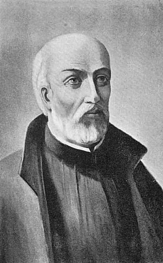
Jean de Brébeuf was a French Jesuit missionary who travelled to New France (Canada) in 1625. There he worked primarily with the Huron for the rest of his life, except for a few years in France from 1629 to 1633. He learned their language and culture, writing extensively about each to aid other missionaries.

The St. Marys River, sometimes written St. Mary's River, drains Lake Superior, starting at the end of Whitefish Bay and flowing 74.5 miles (119.9 km) southeast into Lake Huron, with a fall of 23 feet (7.0 m). For its entire length it is an international border, separating Michigan in the United States from Ontario, Canada.
Étienne Brûlé was the first European explorer to journey beyond the St. Lawrence River into what is now known as Canada. He spent much of his early adult life among the Hurons, and mastered their language and learned their culture. Brûlé became an interpreter and guide for Samuel de Champlain, who later sent Brûlé on a number of exploratory missions, among which he is thought to have preceded Champlain to the Great Lakes, reuniting with him upon Champlain's first arrival at Lake Huron. Among his many travels were explorations of Georgian Bay and Lake Huron, as well as the Humber and Ottawa Rivers. Champlain agreed to send Brûlé, at his own request, as an interpreter to live among the Onontchataron, an Algonquin people, in 1610. In 1629, during the Anglo-French War, he escaped after being captured by the Seneca tribe. Brûlé was killed by the Bear tribe of the Huron people, who believed he had betrayed them to the Seneca.
Algoma District is a district and census division in Northeastern Ontario in the Canadian province of Ontario.

Southern Ontario is a primary region of the Canadian province of Ontario. It is the most densely populated and southernmost region in Canada, with approximately 13.5 million people, approximately 36% of Canada's population of 37 million. The region lies south of the province's other primary region, Northern Ontario, although the exact northern boundary of Southern Ontario is disputed. However, its core region is situated south of Algonquin Park, the latter being in an area of transition between coniferous forest north of the French and Mattawa Rivers and southern deciduous forest. It covers between 14 and 15% of the province, depending on the inclusion of the Parry Sound and Muskoka districts which also lie in the transitional area between northern and southern forest regions. Southern Ontario differs greatly from Northern Ontario, having a much higher population density, a different climate, and a different culture than its northern counterpart. It is broken into smaller subregions, including Central Ontario, Eastern Ontario, the Golden Horseshoe, and Southwestern Ontario.

Clinton is a community in the Canadian province of Ontario, located in the municipality of Central Huron. Clinton was established in 1831, when Jonas Gibbings and brothers Peter and Stephen Vanderburg cleared out a small area to start. Clinton started to grow in 1844 when William Rattenbury laid out the plans to begin making a village. In 1954, Clinton's population was 2,625 people. Today, it has an estimated population of 3,203.
Blind River is a town situated on the North Channel of Lake Huron in the Algoma District, Ontario, Canada. The town, named after the nearby Blind River, celebrated its centennial in 2006.

The Neutral Confederacy was a tribal confederation of Iroquoian peoples. Its heartland was in the floodplain of the Grand River in what is now Ontario, Canada. At its height, its wider territory extended toward the shores of lakes Erie, Huron, and Ontario, as well as the Niagara River in the east. To the northeast were the neighbouring territories of Huronia and the Petun Country, which were inhabited by other Iroquoian confederacies from which the term Neutrals Attawandaron was derived. The five-nation Iroquois Confederacy was across Lake Ontario to the southeast.

Sainte-Marie among the Hurons was a French Jesuit settlement in Huronia or Wendake, the land of the Wendat, near modern Midland, Ontario, from 1639 to 1649. It was the first European settlement in what is now the province of Ontario. Eight missionaries from Sainte-Marie were martyred, and were canonized by the Catholic Church in 1930. Sainte-Marie Among the Hurons was designated a National Historic Site of Canada in 1920. A reconstruction of the mission now operates as a living museum.

The history of Ontario covers the period from the arrival of Paleo-Indians thousands of years ago to the present day. The lands that make up present-day Ontario, the most populous province of Canada as of the early 21st century have been inhabited for millennia by groups of Aboriginal people, with French and British exploration and colonization commencing in the 17th century. Before the arrival of Europeans, the region was inhabited both by Algonquian and Iroquoian tribes.

Goderich is a town in the Canadian province of Ontario and is the county seat of Huron County. The town was founded by John Galt and William "Tiger" Dunlop of the Canada Company in 1827. First laid out in 1828, the town is named after Frederick John Robinson, 1st Viscount Goderich, who was prime minister of the United Kingdom at the time. It was incorporated as a town in 1850.
St. Joseph Island is in the northwestern part of Lake Huron. It is part of the Canadian province of Ontario. At 365 km2 (141 sq mi) in area, it is the sixth largest lake island in the world; the second largest island on Lake Huron, following Manitoulin Island; and the third largest of all the islands on the Great Lakes, trailing Manitoulin and Lake Superior's Isle Royale.
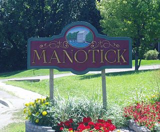
Manotick is a community in Rideau-Jock Ward in the rural south part of the City of Ottawa, Ontario, Canada. It is a suburb of the city, located on the Rideau River, immediately south of the suburbs Barrhaven and Riverside South, about 25 km (16 mi) from downtown Ottawa. It was founded by Moss Kent Dickinson in 1864. He named the village 'Manotick', after the Algonquin word for 'island'. It has been part of the City of Ottawa since amalgamation in 2001. Prior to that, it was located in Rideau Township. According to the Canada 2016 Census, Manotick had a population of 4,486.
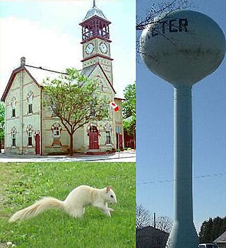
Exeter is a community in the municipality of South Huron, in the southern portion of Huron County, Ontario, Canada, located approximately 40 kilometres north of London. The community proclaims itself the "Home of the White Squirrel", owing to the presence of the unusually-coloured mammals. Exeter's mascot, "Willis The White Wonder", can be seen at many community events throughout the year, including Canada Day celebrations, the Exeter Rodeo, and the Santa Claus Parade.
Narcisse Cantin created the French Canadian settlement of Johnson’s Mills, now known as St. Joseph. He was known as "The Father of the St. Lawrence Seaway".
The history of Ottawa, capital of Canada, was shaped by events such as the construction of the Rideau Canal, the lumber industry, the choice of Ottawa as the location of Canada's capital, as well as American and European influences and interactions. By 1914, Ottawa's population had surpassed 100,000 and today it is the capital of a G7 country whose metropolitan population exceeds one million.

