Bayfield, Ontario

Last updated

Bayfield
Summer evening in Bayfield - 2.jpg
Marina in Bayfield
Canada Southern Ontario location map 2.png
Red pog.svg
Bayfield
Location in southern Ontario
Coordinates: 43°33′36″N81°41′57″W / 43.56000°N 81.69917°W / 43.56000; -81.69917 [1]
Country Canada
Province Ontario
County Huron County
Municipality Bluewater
Founded1832 (1832)
Founded byCarel Lodewijk
Time zone UTC-5 (Eastern Time Zone)
  Summer (DST) UTC-4 (Eastern Time Zone)
Area codes 519, 226, 548

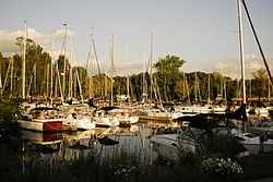
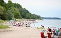
Bayfield is a community in the municipality of Bluewater, Huron County in southwestern Ontario, Canada [1] [2] [3] [4] [5] with a 2016 population of 1,112. [6] Bluewater Municipality includes Bayfield, Bruce field, Dashwood, Hensall, Varna, and Zurich [7] This municipality is made up of 92.8% English speaking people, 6.3% of other language speaking people and 0.9% of French speaking people as of 2016. In addition to this the majority of Bayfield's population is made up of Canadians, creating 88.2% of the population in the year 2016. [8] It is on the eastern shore of Lake Huron at the mouth of Bayfield River. [4] [5] Bayfield is a popular tourist destination. Visitors enjoy the historic Main Street with its many well-preserved old buildings, [9] including the Little Inn which has served travelers since the 1800s, initially as a stagecoach stop. [10] Main Street is lined with boutique shops, art galleries and fine dining restaurants. The nearby marina and public beaches draw crowds in the summer months.

Contents

History

Bayfield Harbour, 1910 Harbor, Bayfield, Ontario, Canada (1910).jpg
Bayfield Harbour, 1910

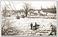
Bayfield was founded in 1832 by Carel Lodewijk, Baron van Tuyll van Serooskerken (1784-1835), a Dutch nobleman who had purchased 388 acres (157 ha) in the area, part of a much larger holding in the Huron Tract that he purchased from the Canada Company. [11] [12] Over the next 10 years, a plan was laid out for the community and two mills (grist and lumber) were built. It was named for noted Great Lakes surveyor and British naval officer Admiral Henry Wolsey Bayfield, who had personally selected the site for the community. [13]

The mouth of the Bayfield River is a natural sheltered harbour [11] and by 1869, the settlement was a port of entry and vessels touched here on their route from Detroit to Goderich. Stages travelled daily to Seaforth. [14] In 1869, when the population was only 125, the settlement had a wagon and plough making shop, two blacksmiths, a distiller, a brickyard and two tanneries. A large, permanent harbour was built during the 1870s. [11] By 1876, Bayfield was incorporated as a village, with a population of 846. [11] [15] In 1982, Bayfield was declared a heritage conservation district. [16]

The Town Hall was built in 1882 and was not moved to its present location on Clan Gregor Square until 1920. By then, Bayfield had been in decline for at least 20 years, because the railway was built far from this area. [9] By 1984, it was closed as a fire hazard; fund raising allowed for repairs, and the hall was re-opened in 1993. On January 1, 2001, Bayfield merged with Hensall, Zurich, Stanley and Hay to create Bluewater Municipality [17] [18] and the Bayfield Town Hall was used for community events. Additional upgrades to the building were made in 2013 and 2016. [11]

Geography

Climate

As Blue Water is located on the eastern shore of Lake Huron this has impacted the climate of the region, having an influence of rain and snow in the community close to the shores. [19]

Climate data for Bayfield, Ontario
MonthJanFebMarAprMayJunJulAugSepOctNovDecYear
Record high °C (°F)11.9
(53.4)
18.5
(65.3)
23.6
(74.5)
23.9
(75.0)
29.8
(85.6)
32.0
(89.6)
32.0
(89.6)
34.4
(93.9)
30.4
(86.7)
25.5
(77.9)
19.9
(67.8)
16.7
(62.1)
34.4
(93.9)
Mean daily maximum °C (°F)−0.7
(30.7)
2.5
(36.5)
5.2
(41.4)
11.0
(51.8)
18.0
(64.4)
22.7
(72.9)
24.1
(75.4)
23.6
(74.5)
21.0
(69.8)
14.2
(57.6)
7.5
(45.5)
1.4
(34.5)
12.5
(54.6)
Mean daily minimum °C (°F)−7.3
(18.9)
−4.7
(23.5)
−2.6
(27.3)
1.4
(34.5)
7.4
(45.3)
12.6
(54.7)
14.3
(57.7)
13.4
(56.1)
10.7
(51.3)
5.2
(41.4)
1.2
(34.2)
−4.6
(23.7)
3.9
(39.1)
Record low °C (°F)−24.2
(−11.6)
−17.6
(0.3)
−21.8
(−7.2)
−6.4
(20.5)
−1.0
(30.2)
3.8
(38.8)
6.9
(44.4)
5.2
(41.4)
0.7
(33.3)
−2.7
(27.1)
−14.6
(5.7)
−16.5
(2.3)
−24.2
(−11.6)
Source: Environment Canada, The Weather Network

Demographics

In the 2021 Census of Population conducted by Statistics Canada, Bayfield had a population of 1,250 living in 628 of its 906 total private dwellings, a change of

Arts and culture

As a small community Bayfield has many yearly traditions which include the Bayfield Fair in August, and Christmas in Bayfield, which takes place the weekend after Remembrance Day and includes the lighting of the trees in Clan Gregor Square as well as an annual Christmas Parade. Other annual events include the Fireman's Breakfast, Pioneer Park 5k Run, Santa Run, Halloween Witches Walk, and Corvette Fest and Volks Fest.[ citation needed ]

Bayfield has the largest croquet club in North America and members compete internationally.

The Bayfield Historical Society operates a heritage centre containing historic artifacts, newspapers, and photographs. Tours are available. [21]

Infrastructure

Transportation

Bayfield is located on Kings Highway 21 which is also known as Bluewater Highway, [22] 20 kilometres (12 mi) south of Goderich. [4] [5]

Related Research Articles

<span class="mw-page-title-main">Brussels, Ontario</span> Unincorporated Community in Ontario, Canada

Brussels is a community within the Municipality of Huron East in Huron County, Ontario, Canada. It held village status prior to 2001. The most recent population estimate was 993 residents in 2021.

<span class="mw-page-title-main">Huron County, Ontario</span> County in Ontario, Canada

Huron County is a county of the province of Ontario, Canada. It is located on the southeast shore of its namesake, Lake Huron, in the southwest part of the province. The county seat is Goderich, also the county's largest community.

<span class="mw-page-title-main">Tiny, Ontario</span> Township in Ontario, Canada

Tiny, also known as Tiny Township, is a township in Simcoe County, south-central Ontario, Canada. The Township of Tiny can be found in the southern Georgian Bay region and is approximately 30 kilometres (19 mi) long or 410 square kilometres (160 sq mi).

<span class="mw-page-title-main">Bayfield River</span> River in Ontario, Canada

The Bayfield River is a river in Huron and Perth Counties in southwestern Ontario, Canada, that empties into Lake Huron at the community of Bayfield in the municipality of Bluewater.

<span class="mw-page-title-main">Maitland River</span> River in Ontario, Canada

The Maitland River is a river in Huron County, Perth County and Wellington County in Southwestern Ontario, Canada. The river is in the Great Lakes Basin and empties into Lake Huron at the town of Goderich. It is 150 kilometres (93 mi) long, and is named after Sir Peregrine Maitland, Lieutenant-Governor of Upper Canada from 1818 to 1828. It was formerly known as the Menesetung River.

<span class="mw-page-title-main">Southwestern Ontario</span> Secondary region in Ontario, Canada

Southwestern Ontario is a secondary region of Southern Ontario in the Canadian province of Ontario. It occupies most of the Ontario Peninsula bounded by Lake Huron, including Georgian Bay, to the north and northwest; the St. Clair River, Lake St. Clair, and Detroit River, to the west; and Lake Erie to the south. To the east, on land, Southwestern Ontario is bounded by Central Ontario and the Golden Horseshoe.

<span class="mw-page-title-main">Goderich, Ontario</span> Town in Ontario, Canada

Goderich is a town in the Canadian province of Ontario and is the county seat of Huron County. The town was founded by John Galt and William "Tiger" Dunlop of the Canada Company in 1827. First laid out in 1828, the town is named after Frederick John Robinson, 1st Viscount Goderich, who was prime minister of the United Kingdom at the time. It was incorporated as a town in 1850.

Huron South was a federal electoral district in Ontario, Canada, that was represented in the House of Commons of Canada from 1867 to 1935. It was created by the British North America Act of 1867 which divided the County of Huron into two ridings: Huron North and Huron South.

<span class="mw-page-title-main">Central Huron</span> Municipality in Ontario, Canada

Central Huron is a township in western Ontario, Canada, in Huron County. It is situated on Lake Huron between the Maitland River and the Bayfield River.

<span class="mw-page-title-main">Tara, Ontario</span> Community in Ontario, Canada

Tara is an unincorporated community in the municipality of Arran–Elderslie, Bruce County, in southwestern Ontario, Canada. It is a designated place and had 1,037 residents and 458 dwellings as of the 2011 census. Tara is in geographic Arran Township and is located on the Sauble River. It has an area of 2.39 square kilometres (0.92 sq mi) and an urban area that covers 63.5 square kilometres (24.5 sq mi).

<span class="mw-page-title-main">Port Elgin, Ontario</span> Community in Ontario, Canada

Port Elgin is a community in the town of Saugeen Shores, Ontario, Canada. Its location is in the traditional territory of the Saugeen Ojibway Nation. Originally named Normanton the town was renamed Port Elgin when it was incorporated in 1874, after James Bruce, 8th Earl of Elgin, a former Governor General of the Province of Canada.

<span class="mw-page-title-main">Thessalon</span> Town in Ontario, Canada

Thessalon is a town in the Canadian province of Ontario, located at the junction of Highway 17 and Highway 129 on the north shore of Lake Huron. It is surrounded by, but not part of, the municipality of Huron Shores, and is part of Algoma District. The main industries are timber and tourism. The town is a popular retirement community. It is the administrative headquarters of the Thessalon First Nation.

<span class="mw-page-title-main">Exeter, Ontario</span> Town in Ontario, Canada

Exeter is a community in the municipality of South Huron, in the southern portion of Huron County, Ontario, Canada, located approximately 40 kilometres north of London. The community proclaims itself the "Home of the White Squirrel", owing to the presence of the unusually-coloured mammals. Exeter's mascot, "Willis The White Wonder", can be seen at many community events throughout the year, including Canada Day celebrations, the Exeter Rodeo, and the Santa Claus Parade.

<span class="mw-page-title-main">Hensall, Ontario</span>

Hensall is a community in Bluewater, Ontario, Canada with a population of 1,173. It is located in the centre of Huron County's agricultural land, and is home to three large processing facilities: Thompsons Limited, Hensall Co-op and Cook's Division of Parrish & Heimbecker Ltd., where thousands of tons of beans are annually processed, packaged and shipped worldwide.

<span class="mw-page-title-main">Ashfield–Colborne–Wawanosh</span> Township in Ontario, Canada

The Township of Ashfield–Colborne–Wawanosh is a municipality in Huron County, Ontario, Canada. It was formed as an amalgamation of the former Ashfield, Colborne and West Wawanosh townships in 2001, in an Ontario-wide local government restructuring imposed by the government of that time. The three former townships now comprise the wards of the amalgamated municipality.

<span class="mw-page-title-main">Bluewater, Ontario</span> Municipality in Ontario, Canada

Bluewater is a municipality located in Huron County, Ontario, which is part of Southwestern Ontario, Ontario, Canada. As of 2016, the municipality has a population of 7,136.

<span class="mw-page-title-main">Huron East, Ontario</span> Municipality in Ontario, Canada

The Municipality of Huron East is a Canadian municipality located in Huron County, Ontario. It was formed in 2001 as an amalgamation of the former Grey, McKillop and Tuckersmith townships with the town of Seaforth and village of Brussels, due to an Ontario-wide local government restructuring imposed by the government of that time. The municipality is structured as five wards based on the former townships, town and village.

<span class="mw-page-title-main">Port Franks, Ontario</span> Place in Ontario, Canada

Port Franks is a small Southern Ontario community in the municipality of Lambton Shores, Lambton County in southwestern Ontario, Canada. It is located along Kings Highway 21 near Pinery Provincial Park, about 8 kilometres (5.0 mi) north of Thedford, Ontario. Archaeological evidence suggests that human habitation and use of this site date back thousands of years, and that locally obtained flint was manufactured at the so-called 'flint chipping beds' in the vicinity long before the period of European contact with First Nations peoples in the Great Lakes Basin.

Sodom, Ontario, was a small Canadian logging industry-based community that existed in the last quarter of the 19th and first half of the 20th century. It was located on the boundary between the present day municipalities of South Huron and Bluewater, Ontario, Canada, on Dashwood Road approximately 500 meters west of the present-day intersection of Dashwood Road and Ausable Line, at the point at which Dashwood Road bridges the Ausable River. The original site of the community is now occupied by South Huron and Bluewater.

The Middlesex and Huron Regiment was an infantry regiment of the Non-Permanent Active Militia of the Canadian Militia. It was formed in 1936, as a result of the Amalgamation of The Middlesex Light Infantry and The Huron Regiment. In 1946, the regiment was disbanded.

References

  1. 1 2 "Bayfield". Geographical Names Data Base . Natural Resources Canada . Retrieved 2020-05-31.
  2. "Toporama (on-line map and search)". Atlas of Canada . Natural Resources Canada. Retrieved 2020-05-31.
  3. Restructured municipalities - Ontario map #6 (Map). Restructuring Maps of Ontario. Ontario Ministry of Municipal Affairs and Housing. 2006. Archived from the original on 2021-02-24. Retrieved 2020-05-31.
  4. 1 2 3 "Ontario Geonames GIS (on-line map and search)". Ontario Ministry of Natural Resources and Forestry. 2014. Retrieved 2020-05-31.
  5. 1 2 3 Map 2 (PDF) (Map). 1 : 700,000. Official road map of Ontario. Ministry of Transportation of Ontario. 2018-01-01. Retrieved 2020-05-31.
  6. Census Profile, 2016, Statistics Canada
  7. "Municipality of Bluewater". Municipality of Bluewater. Archived from the original on 2016-07-08. Retrieved 24 February 2021.
  8. Brinkhoff, Thomas (January 23, 2018). "City Population". City Population. Archived from the original on 2021-04-10. Retrieved February 24, 2021.
  9. 1 2 Ron Brown (2016). Backroads of Ontario (4th ed.). Firefly Books. p. 49. ISBN   978-1770857070.
  10. Little Inn Retrieved 3 July 2018.
  11. 1 2 3 4 5 History of Bayfield, Ontario Archived 2017-06-02 at the Wayback Machine Retrieved 3 July 2018.
  12. "The founding of Bayfield" . Retrieved 3 July 2018.
  13. Rayburn, Alan (1997), Place Names of Ontario (University of Toronto Press), Toronto-Buffalo-London, ISBN   0-8020-7207-0), pg.25.
  14. The province of Ontario gazetteer and directory. H. McEvoy Editor and Compiler, Toronto : Robertson & Cook, Publishers, 1869.
  15. Ontario (1876). Statutes of the Province of Ontario. p. 165.
  16. "Municipality of Bluewater homepage". www.municipalityofbluewater.ca. Retrieved 2021-02-27.
  17. "Moving to Bayfield? A guide to Living in Bayfield, Ontario [2020 Edition]". teamForster. 7 April 2020. Archived from the original on 2020-09-24. Retrieved 24 February 2021.
  18. "Bluewater Official Plan" (PDF). municipalityofbluewater.ca. 2005-04-05. Archived (PDF) from the original on 2021-08-26. Retrieved 2021-08-26.
  19. "Moving to Bayfield? A guide to Living in Bayfield, Ontario [202 Edition]". TeamForster. 7 April 2020. Archived from the original on 2020-09-24. Retrieved 24 February 2021.
  20. "Population and dwelling counts: Canada and designated places". Statistics Canada. February 9, 2022. Retrieved Sep 2, 2022.
  21. "Bayfield Historical Society & Archives Welcome". www.bayfieldhistorical.ca. Retrieved 2021-02-27.
  22. "Moving to Bayfield? A Guide to Living in Bayfield Ontario [2020 Edition]". Homesinlondonontario.ca. Retrieved 2021-02-24.