
Bruce County is a county in Southwestern Ontario, Canada comprising eight lower-tier municipalities and with a 2016 population of 66,491. It is named for James Bruce, 8th Earl of Elgin and 12th Earl of Kincardine, sixth Governor General of the Province of Canada. The Bruce name is also linked to the Bruce Trail and the Bruce Peninsula. It has three distinct areas. The Peninsula is part of the Niagara Escarpment and is known for its views, rock formations, cliffs, and hiking trails. The Lakeshore includes nearly 100 km of fresh water and soft sandy beaches. Finally, the Interior Region has a strong history in farming.

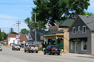
Wingham is a community located in the municipality of North Huron, Ontario, Canada, which is located in Huron County. Wingham became part of North Huron in 2001 when the Ontario government imposed amalgamation on the former township of East Wawanosh, the village of Blyth, and the town of Wingham.
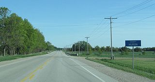
Huron County is a county of the province of Ontario, Canada. It is located on the southeast shore of its namesake, Lake Huron, in the southwest part of the province. The county seat is Goderich, also the county's largest community.
Middlesex Centre is a township in Middlesex County, in southwestern Ontario, Canada, north and west of London. The Corporation of the Township of Middlesex Centre formed on January 1, 1998, with the amalgamation of the former Townships of Delaware, Lobo, and London. It is part of the London census metropolitan area.

South Glengarry is a township in eastern Ontario, Canada on the Saint Lawrence River in the United Counties of Stormont, Dundas and Glengarry. South Glengarry borders Quebec.

The Maitland River is a river in Huron County, Perth County and Wellington County in Southwestern Ontario, Canada. The river is in the Great Lakes Basin and empties into Lake Huron at the town of Goderich. It is 150 kilometres (93 mi) long, and is named after Sir Peregrine Maitland, Lieutenant-Governor of Upper Canada from 1818 to 1828. It was formerly known as the Menesetung River.

Goderich is a town in the Canadian province of Ontario and is the county seat of Huron County. The town was founded by John Galt and William "Tiger" Dunlop of the Canada Company in 1827. First laid out in 1828, the town is named after Frederick John Robinson, 1st Viscount Goderich, who was prime minister of the United Kingdom at the time. It was incorporated as a town in 1850.

Huron—Bruce is a federal electoral district in Ontario, Canada, that has been represented in the House of Commons of Canada since 1953.
Huron North was a federal electoral district represented in the House of Commons of Canada from 1867 to 1882, and from 1917 to 1953. It was located in the province of Ontario. It was created by the British North America Act of 1867 which divided the County of Huron into two ridings: Huron North and Huron South.
Huron East was a federal electoral district represented in the House of Commons of Canada from 1882 to 1917. It was located in the province of Ontario. This riding was created from parts of Huron Centre, Huron North and Huron South ridings.
Huron West was a federal electoral district represented in the House of Commons of Canada from 1882 to 1917. It was located in the province of Ontario. This riding was created from parts of Huron Centre, Huron North and Huron South ridings.

Central Huron is a township in western Ontario, Canada, in Huron County. It is situated on Lake Huron between the Maitland River and the Bayfield River.
Blyth is a village in North Huron, Huron County, Ontario, Canada.
The Township of Ashfield–Colborne–Wawanosh is a municipality in Huron County, Ontario, Canada. It was formed as an amalgamation of the former Ashfield, Colborne and West Wawanosh townships in 2001, in an Ontario-wide local government restructuring imposed by the government of that time. The three former townships now comprise the wards of the amalgamated municipality. Mayor of Dungannon Robert Brindley Jr.

The Township of North Huron is a municipality in Huron County, Ontario, Canada. It was formed in 2001 when the Ontario government imposed amalgamation on municipalities throughout the province. Specifically, the former township of East Wawanosh was merged with the village of Blyth and the town of Wingham.

Walsh is a medium-sized hamlet in Norfolk County, Ontario, Canada.
Saltford is a small unincorporated community in Ontario, Canada, located at the intersection of Highway 21 and Saltford Road, on the east bank of the Maitland River in the township of Ashfield-Colborne-Wawanosh just east of Goderich. In early 1866, local entrepreneur Samuel Platt discovered the presence of brine while drilling for oil in the community. He subsequently developed a salt extraction business, using an evaporation process. This discovery inspired the development of several salt extraction operations in the immediate area, eventually culminating in the opening of the Sifto Salt mine in nearby Goderich, currently (2007) the third largest salt producer in the world.

Kingsbridge, Ontario is a small rural community in southwestern Ontario within the municipality of Ashfield–Colborne–Wawanosh in Huron County. It is approximately 22 kilometres north of Goderich on the Bluewater Highway where it intersects with Kingsbridge Line. The area around Kingsbridge was settled in 1839 by Irish immigrants from County Kerry, Ireland. During the 1840s and 1850s many more Irish families, mostly from Kerry, although some from Counties Clare, Cork, and Tipperary, settled in the vicinity. Kingsbridge was named for John King, who constructed a bridge in the area in the 1850s. The community's primary landmarks include St. Joseph's Church, an elementary school, and the former St. Joseph's convent. The community overlooks Lake Huron and is surrounded by rich farmland.
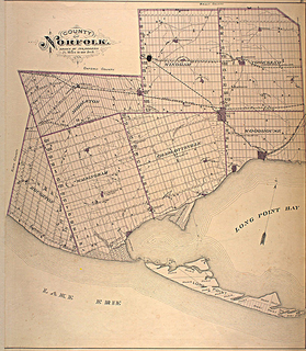
Norfolk County in the Canadian province of Ontario consists of a long list of communities. Its four designated population centres are Simcoe, Port Dover, Delhi, and Waterford.
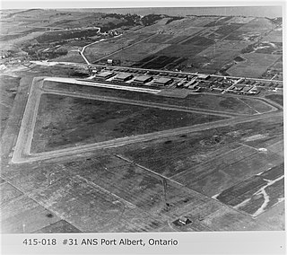
RCAF Station Port Albert was a Second World War, Royal Canadian Air Force station located near Port Albert, Ontario, Canada in the Ashfield–Colborne–Wawanosh township. The station was home to the Royal Air Force's No. 31 Air Navigation School.


