The Raisin River is a river in South Stormont and South Glengarry, United Counties of Stormont, Dundas and Glengarry in eastern Ontario, Canada, with the watershed encompassing portions of North Stormont, North Glengarry and the city of Cornwall as well. It empties into Lake Saint Francis on the Saint Lawrence River near the community of Lancaster.
The Nith River is a river in Brant, Oxford and Perth Counties and the Regional Municipality of Waterloo in Southwestern Ontario, Canada. The Nith River is approximately 125km in length and empties into the Grand River at the town of Paris. It is named after the River Nith in Scotland.

The Seguin River is a river in Parry Sound District in central Ontario, Canada that empties into Parry Sound on Georgian Bay, Lake Huron at the town of Parry Sound. The river's name comes from the Ojibwe word ziigwan, meaning "spring".
The Moira River is a river in Hastings County in eastern Ontario, Canada. It travels from its source in the centre of the county to the Bay of Quinte at the county seat Belleville.

The Sauble River is a river in Bruce County and Grey County in southwestern Ontario, Canada that flows from its headwaters in the township of Chatsworth to Lake Huron at the community of Sauble Beach.

The Ausable River is a river in southwestern Ontario Canada which empties into Lake Huron at Port Franks, Ontario. The Ausable's initial source is in a moraine near the community of Staffa, Ontario located in the municipality of West Perth, Ontario at a point 334 metres (1,096 ft) above sea level. Although the river has a total measured length of over 240 kilometres (150 mi), because of its meandering course, the mouth in actuality is only 64 kilometres (40 mi) from its source near Staffa. The Ausable drains 1,142 square kilometers (441 sq mi) of land, and falls 158 metres (518 ft) in elevation from source to outlet.

The Maitland River is a river in Huron County, Perth County and Wellington County in Southwestern Ontario, Canada. The river is in the Great Lakes Basin and empties into Lake Huron at the town of Goderich. It is 150 kilometres (93 mi) long, and is named after Sir Peregrine Maitland, Lieutenant-Governor of Upper Canada from 1818 to 1828. It was formerly known as the Menesetung River.

Exeter is a community in the municipality of South Huron, in the southern portion of Huron County, Ontario, Canada, located approximately 40 kilometres north of London. The community proclaims itself the "Home of the White Squirrel", owing to the presence of the unusually-coloured mammals. Exeter's mascot, "Willis The White Wonder", can be seen at many community events throughout the year, including Canada Day celebrations, the Exeter Rodeo, and the Santa Claus Parade.

Bluewater is a municipality located in Huron County, Ontario, which is part of Southwestern Ontario, Ontario, Canada. As of 2016, the municipality has a population of 7,136.

Bayfield is a community in the municipality of Bluewater, Huron County in southwestern Ontario, Canada with a 2016 population of 1,112. Bluewater Municipality includes Bayfield, Bruce field, Dashwood, Hensall, Varna, and Zurich This municipality is made up of 92.8% English speaking people, 6.3% of other language speaking people and 0.9% of French speaking people as of 2016. In addition to this the majority of Bayfield's population is made up of Canadians, creating 88.2% of the population in the year 2016. It is on the eastern shore of Lake Huron at the mouth of Bayfield River. Bayfield is a popular tourist destination. Visitors enjoy the historic Main Street with its many well-preserved old buildings, including the Little Inn which has served travelers since the 1800s, initially as a stagecoach stop. Main Street is lined with boutique shops, art galleries and fine dining restaurants. The nearby marina and public beaches draw crowds in the summer months.
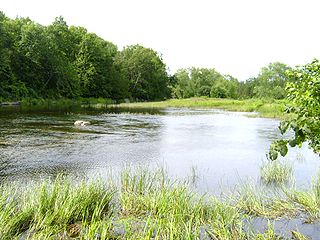
Hay Swamp is a provincially significant wetland complex, 1839 hectares in size, located in parts of the central land areas of the municipalities of Bluewater and South Huron, in southwestern Ontario, Canada. Approximately 13 kilometers (8.1 mi) in length and 2 kilometers (1.2 mi) in width, at its widest point; it consists of 15 extensively forested individual wetlands, situated on either side, of sections of both the upper drainage of the Ausable River and its tributary, Black Creek.
Silver Creek is a river in the municipality of Huron East, Huron County, Ontario, Canada and a right tributary of the Bayfield River.

The Montreal River is a river in Timiskaming District, Ontario, Canada. It travels 220 kilometres (137 mi) from its source at Smoothwater Lake to its mouth at Lake Timiskaming on the Ottawa River. The river is a significant source of hydroelectricity.

The Whitefish River is a river in the James Bay and Moose River drainage basins in Cochrane and Timiskaming Districts in northeastern Ontario, Canada. It flows 75 kilometres (47 mi) from Mount Sinclair Lake to its mouth at Night Hawk Lake, the source of the Frederick House River, a tributary of the Abitibi River.
The Huron Tract Purchase also known as the Huron Block, registered as Crown Treaty Number 29, is a large area of land in southwestern Ontario bordering on Lake Huron to the west and Lake Erie to the east. The area spans the counties of Huron, Perth, Middlesex and present day Lambton County, Ontario in the province of Ontario.
The Vermilion River is a river in the Lake Huron drainage basin in Sudbury District and Greater Sudbury in Northeastern Ontario, Canada.

The Beaver River is a river in Grey County and Simcoe County in Southern Ontario, Canada. It is part of the Great Lakes Basin, and is a tributary of Lake Huron. The river's drainage basin is under the auspices of Grey Sauble Conservation.
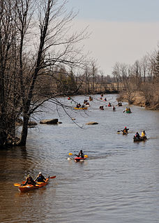
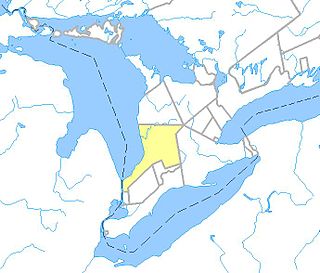
Ausable Bayfield Conservation Authority (ABCA) is a local conservation agency named in the Ontario Conservation Authorities Act. Located in Southern Ontario, the agency focuses on the conservation of the drainage basins of the Ausable River, Bayfield River, Parkhill Creek, and Gullies watersheds. The headquarters is located in Exeter, Ontario.
The Little White River is a river in the Unorganized North Part of Algoma District in Northeastern Ontario, Canada. It is in the Great Lakes Basin and is a left tributary of the Mississagi River.
The Black River is a river in Simcoe County, the District Municipality of Muskoka, the City of Kawartha Lakes, and Haliburton County in Central Ontario, Canada. It is part of the Great Lakes Basin, and is a right tributary of the Severn River.

