
The Mississippi River is a tributary of the Ottawa River in Eastern Ontario, Canada which has no relation with the Mississippi River in the United States. It is 200 kilometres (120 mi) in length from its source at Mackavoy Lake, has a drainage area of 4,450 square kilometres (1,720 sq mi), and has a mean discharge of 40 cubic metres per second (1,400 cu ft/s). There are more than 250 lakes in the watershed.

The Mississagi River is a river in Algoma and Sudbury Districts, Ontario, Canada, that originates in Sudbury District and flows 266 kilometres (165 mi) to Lake Huron at Blind River, Algoma District.
The Moira River is a river in Hastings County in eastern Ontario, Canada. It travels from its source in the centre of the county to the Bay of Quinte at the county seat Belleville.

The Sauble River is a river in Bruce County and Grey County in southwestern Ontario, Canada that flows from its headwaters in the township of Chatsworth to Lake Huron at the community of Sauble Beach.

The Ausable River is a river in southwestern Ontario Canada which empties into Lake Huron at Port Franks, Ontario. The Ausable's initial source is in a moraine near the community of Staffa, Ontario located in the municipality of West Perth, Ontario at a point 334 metres (1,096 ft) above sea level. Although the river has a total measured length of over 240 kilometres (150 mi), because of its meandering course, the mouth in actuality is only 64 kilometres (40 mi) from its source near Staffa. The Ausable drains 1,142 square kilometers (441 sq mi) of land, and falls 158 metres (518 ft) in elevation from source to outlet.
The Bayfield River is a river in Huron and Perth Counties in southwestern Ontario, Canada, that empties into Lake Huron at the community of Bayfield in the municipality of Bluewater.

The Maitland River is a river in Huron County, Perth County and Wellington County in Southwestern Ontario, Canada. The river is in the Great Lakes Basin and empties into Lake Huron at the town of Goderich. It is 150 kilometres (93 mi) long, and is named after Sir Peregrine Maitland, Lieutenant-Governor of Upper Canada from 1818 to 1828. It was formerly known as the Menesetung River.

The Crowe River is a river in the counties of Haliburton, Hastings, Northumberland and Peterborough in southern Ontario, Canada. It is in the Lake Ontario drainage basin and is a tributary of the Trent River.
The Brightsand River is a river in the James Bay drainage basin in Unorganized Thunder Bay District in northwestern Ontario, Canada.

Conservation Ontario is the umbrella organization which represents all of the conservation authorities in Ontario. This nonprofit organization was founded in 1980/81. Conservation Ontario is the network of 36 Conservation Authorities.
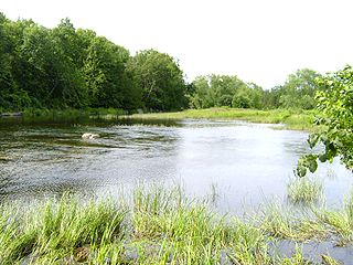
Hay Swamp is a provincially significant wetland complex, 1839 hectares in size, located in parts of the central land areas of the municipalities of Bluewater and South Huron, in southwestern Ontario, Canada. Approximately 13 kilometers (8.1 mi) in length and 2 kilometers (1.2 mi) in width, at its widest point; it consists of 15 extensively forested individual wetlands, situated on either side, of sections of both the upper drainage of the Ausable River and its tributary, Black Creek.
The Beatty Saugeen River is a river in the Saugeen River and Lake Huron drainage basins in Grey County, southwestern Ontario, Canada. It is a tributary of the South Saugeen River.
Blue Jay Creek is a river on Manitoulin Island in Central Manitoulin and Tehkummah townships, Manitoulin District in northeastern Ontario, Canada and a tributary of Lake Huron.
Partridge Creek is a creek in the Moira River and Lake Ontario drainage basins in Hastings and Lennox and Addington Counties, Ontario, Canada.
The Huron Tract Purchase also known as the Huron Block, registered as Crown Treaty Number 29, is a large area of land in southwestern Ontario bordering on Lake Huron to the west and Lake Erie to the east. The area spans the counties of Huron, Perth, Middlesex and present day Lambton County, Ontario in the province of Ontario.
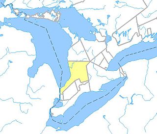
Ausable Bayfield Conservation Authority (ABCA) is a local conservation agency named in the Ontario Conservation Authorities Act. Located in Southern Ontario, the agency focuses on the conservation of the drainage basins of the Ausable River, Bayfield River, Parkhill Creek, and Gullies watersheds. The headquarters is located in Exeter, Ontario.
Darlington Creek is a stream in the municipality of Clarington, Regional Municipality of Durham in Ontario, Canada. It is a tributary of Lake Ontario and is located in geographic Darlington Township, after which it is named.
Bowmanville Creek is a stream in the municipality of Clarington, Regional Municipality of Durham in south-central Ontario, Canada. It flows from the Oak Ridges Moraine to Lake Ontario at Bowmanville. The creek is under the auspices of the Central Lake Ontario Conservation Authority.

The North Sydenham River is a river in the municipalities of Saint Clair and Chatham-Kent in Southwestern Ontario, Canada. It is a tributary of the Sydenham River, and is part of the Great Lakes Basin.
Ruhl Creek is a stream in the township municipality of Brockton, Bruce County in Southwestern Ontario, Canada. It is in the Lake Huron drainage basin and is a right tributary of the Saugeen River.
