
Lander is a city in Wyoming, United States, and the county seat of Fremont County. It is in central Wyoming, along the Middle Fork of the Popo Agie River, just south of the Wind River Indian Reservation. It is a tourism center with several nearby guest ranches. Its population was 7,487 at the 2010 census.

The Wind River Range is a mountain range of the Rocky Mountains in western Wyoming in the United States. The range runs roughly NW–SE for approximately 100 mi (160 km). The Continental Divide follows the crest of the range and includes Gannett Peak, which at 13,802 ft (4,207 m), is the highest peak in Wyoming; and also Fremont Peak at 13,750 ft (4,191 m), the third highest peak in Wyoming. There are more than 40 other named peaks in excess of 12,999 ft (3,962 m). With the exception of the Grand Teton in the Teton Range, the next 19 highest peaks in Wyoming after Gannett are also in the Winds.
North Fork most commonly refers to the peninsula at the east end of the North Shore of Long Island.
Shoshone National Forest is the first federally protected National Forest in the United States and covers nearly 2,500,000 acres (1,000,000 ha) in the state of Wyoming. Originally a part of the Yellowstone Timberland Reserve, the forest is managed by the United States Forest Service and was created by an act of Congress and signed into law by U.S. President Benjamin Harrison in 1891. Shoshone National Forest is one of the first nationally protected land areas anywhere. Native Americans have lived in the region for at least 10,000 years, and when the region was first explored by European adventurers, forestlands were occupied by several different tribes. Never heavily settled or exploited, the forest has retained most of its wildness. Shoshone National Forest is a part of the Greater Yellowstone Ecosystem, a nearly unbroken expanse of federally protected lands encompassing an estimated 20,000,000 acres (8,100,000 ha).

Popo Agie Wilderness is located within Shoshone National Forest, Wyoming, United States. The wilderness consists of 101,870 acres on the east side of the continental divide in the Wind River Range. Originally set aside as a primitive area in 1932, in 1984 the Wyoming Wilderness Act was passed securing a more permanent protection status for the wilderness. The wilderness is a part of the 20,000,000 acres Greater Yellowstone Ecosystem.

Wind River Peak is the highest point in the southern end of the Wind River Range that is located in the U.S. state of Wyoming. The peak straddles the Continental Divide and is surrounded by National Forest lands. The west slopes are in the Bridger Wilderness of Bridger-Teton National Forest, while the east side is in the Popo Agie Wilderness of Shoshone National Forest. In a cirque on the northeast slopes of the peak lies Wind River Glacier.

The Chugwater Formation is a mapped bedrock unit consisting primarily of red sandstone, in the states of Wyoming, Montana, and Colorado in the United States. It is recognized as a geologic formation in Colorado and Montana, but as a Group in Wyoming.

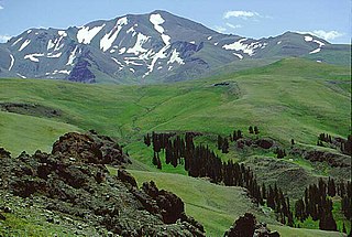
Sinks Canyon State Park is a public recreation and nature preservation area located in the Wind River Mountains, six miles (9.7 km) southwest of Lander, Wyoming, on Wyoming Highway 131. The state park is named for a portion of the Middle Fork of the Popo Agie River where it flows into an underground limestone cavern, named "the Sinks," and emerges a quarter-mile down the canyon in a pool named "the Rise." The park is managed by the Wyoming Division of State Parks and Historic Sites.

Heptasuchus is an extinct genus of loricatan pseudosuchian known from the Middle or Late Triassic upper Chugwater Group of Wyoming, United States. It contains a single species, Heptasuchus clarki, the first formally recognized "rauisuchian" or loricatan pseudosuchian from North America.

Pingora Peak is prominent granite peak in the U.S. state of Wyoming. The peak is one of the pinnacles that forms the Cirque of the Towers. Pingora Peak is in the Popo Agie Wilderness and part of the Wind River Range within the greater Shoshone National Forest. The Northeast Face route on Pingora Peak is recognized in the historic climbing text Fifty Classic Climbs of North America and considered a classic around the world.

Bair Peak is located in the Wind River Range in the U.S. state of Wyoming. The mountain is on the Continental Divide in the Bridger Wilderness of Bridger-Teton National Forest and Popo Agie Wilderness of Shoshone National Forest. Washakie Glacier lies on the north slopes of the peak.

Payson Peak is a mountain located in the southern Wind River Range in the U.S. state of Wyoming. Payson Peak was named after Henry A. Payson, a former Forest Ranger. Payson Peak is in the Popo Agie Wilderness of Shoshone National Forest.
Edward B. Branson was an American geologist and paleontologist. He worked at the University of Missouri.

The Middle Fork Popo Agie River is a river in Wyoming in the United States. The river is 54 miles (87 km) long. The river is sometimes referred to as simply the 'Middle Fork'. The river is part of the Popo Agie Watershed and from its headwaters in the Wind River Range until it joins with the North Fork of the Popo Agie River, the river and its tributaries irrigate roughly 11,503 acres.

The Little Popo Agie River runs through unincorporated portions of Fremont County Wyoming. The river's headwaters are at Christina Lake in the Wind River Range, and it flows a total of 58 miles (93 km) until its end near Hudson, Wyoming. The river is one of three sharing the name "Popo Agie", the others include the Middle Fork Popo Agie and the North Fork Popo Agie River.

Roaring Fork Creek is a creek in Wyoming in the United States. The creek is 15 miles (24 km) long and flows through the Wind River Range. The creek feeds several lakes and reservoirs and is a source of water for Lander, Wyoming.

Bollinger Peak is a 12,232-foot-elevation (3,728 meter) mountain summit located on the shared border of Sublette County and Fremont County in the state of Wyoming, United States.

