
Newcastle upon Tyne, often simply Newcastle, is the most populous city and metropolitan borough in North East England. It forms the Tyneside conurbation's core, eighth most populous United Kingdom urban area. The city is situated on the River Tyne's northern bank, approximately 8.5 mi (13.7 km) from the North Sea. Geordie is a regional nickname and dialect for people from Newcastle and areas under the city and its dialectal influence.
Newcastle upon Tyne Central is a constituency represented in the House of Commons of the UK Parliament since 2010 by Chi Onwurah of the Labour Party. As with all constituencies, the constituency elects one Member of Parliament (MP) by the first past the post system of election at least every five years. At the 2017 and 2019 general elections, the constituency was the first to officially declare its result. It narrowly beat Houghton and Sunderland South, which had declared first in 2010 and 2015 (as did its predecessor Sunderland South in the four preceding general elections.

Newcastle upon Tyne East and Wallsend was, from 1997 until 2010, a constituency represented in the House of Commons of the Parliament of the United Kingdom. It elected one Member of Parliament (MP) by the first past the post system of election.
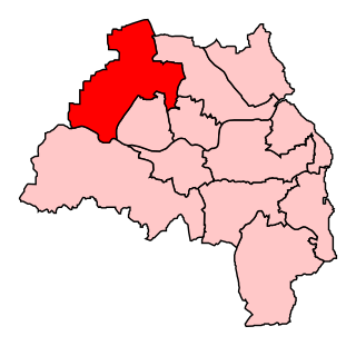
Newcastle upon Tyne North is a constituency represented in the House of Commons of the UK Parliament since 2010 by Catherine McKinnell of the Labour Party.

Walker is a residential suburb and electoral ward just east of the centre of Newcastle upon Tyne, England. The population at the 2011 census was 11,701.

Walkergate is an area and electoral ward in the city of Newcastle upon Tyne in Tyne and Wear, England. It is in the east of the city, north of Walker proper, east of the Heaton area and west of Wallsend. Areas within the Walkergate ward include Daisy Hill, Eastfield, Walkerdene and Walkerville. Walkergate Metro station which was opened in 1982 serves the area. This replaced the previous railway station on the same site which was originally known as Walker station from 1839 to 1889 when it was renamed Walker Gate station.

Longbenton is a district of North Tyneside, England. It is largely occupied by an extensive estate originally built as municipal housing by Newcastle City Council in the 1950s and 1960s. It is served by the Tyne and Wear Metro stations Longbenton Metro station and Four Lane Ends Metro Station. Nearby places are Killingworth, Forest Hall, Four Lane Ends, West Moor, Heaton and South Gosforth, in Newcastle upon Tyne. The Longbenton and Killingworth Urban Area had a population of 34,878 in 2001. This figure increased to 37,070 in 2011.
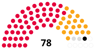
Newcastle City Council is the local government authority for the city and metropolitan borough of Newcastle upon Tyne, Tyne and Wear, North East England. The council consists of 78 councillors, three for each of the city's 26 wards. It is currently controlled by The Labour Party, led by Councillor Nick Forbes. Councillor David Cook serves as the Lord Mayor and Councillor Habib Rahman serves as Deputy Lord Mayor and Sheriff. The council is a member of the North of Tyne Combined Authority.

Byker is a district and electoral ward in the city of Newcastle upon Tyne, located in the east of the city. Byker is home to the Byker Wall estate, made famous by TV series Byker Grove. The population of the ward was recorded at 12,206 in the 2011 Census, which represented approximately 4.4% of the metropolitan borough of Newcastle upon Tyne. Byker is bordered by Heaton to the south and by Shieldfield to the north-east.

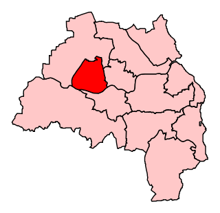
Newcastle upon Tyne East is a constituency represented in the House of Commons of the UK Parliament by Nick Brown of the Labour Party. Brown has held the seat since its recreation in 2010.

Heaton is a suburb in the east end of Newcastle upon Tyne, England, about 2 miles (3 km) from the city centre. It is bordered by the neighbouring areas of High Heaton and Cochrane Park to the north, Walker and Walkergate to the east, Byker to the south and Jesmond and Sandyford to the west. The name Heaton means high town, referring to the area "being situated on hills above the Ouseburn, a tributary of the River Tyne."

Blakelaw is an electoral ward situated in the West End of the city of Newcastle upon Tyne in North East England. The population of the ward is 11,186, which is 4.6% of the city's population. Car ownership in the area is 50.6%: this is lower than the city average of 54.7%, increasing to 11,507 at the 2011 Census. House prices in this area average at £114,000.

Kenton is a suburb and electoral ward in the north west of Newcastle upon Tyne, England. Birth place of Billy Buck.It borders the Town Moor and Gosforth. Kenton also has close road links to Newcastle Airport. The ward population at the 2011 Census was 11,605.
Sir Neville Guthrie Trotter, FCIT is a retired British Conservative politician.

South Heaton was a ward of Newcastle City Council in Newcastle upon Tyne, England. It covers the southern part of the Heaton district, and some north eastern parts of neighbouring Byker. It was abolished in 2018 and replaced by a new ward named Heaton.
Dene is an electoral ward of Newcastle upon Tyne in North East England. The ward takes its name from the nearby gorge at Jesmond Dene. Contained within the ward are government offices of the Department for Work and Pensions and the Freeman Hospital. The population of the ward is 9,554, increasing to 9,667 at the 2011 Census, 3.7% of the total population of Newcastle upon Tyne. Car ownership in the area is 74.8% much higher than the city average of 54.7%.
Benwell and Scotswood is an electoral ward of Newcastle upon Tyne in North East England. The ward encompasses the Benwell and Scotswood housing areas, as well as the Newcastle Business Park, which is located on the banks of the River Tyne and houses offices of companies such as British Airways and the Automobile Association. The population of the ward is 13,759, which is 5.3% of the total population of Newcastle upon Tyne. Car ownership in the area is 45.1%, lower than the city average of 54.7%. The 2011 Census gave a population of 12,694.
East Gosforth also known as Gosforth East is an electoral ward in Newcastle upon Tyne, Tyne and Wear, UK. It was created in 2004. The population of the ward is 8,981, increasing to 10,145 at the 2011 Census, 3.5% of the total population of Newcastle upon Tyne. Car ownership in the area is 68.8%, higher than the city average of 54.7%. It is one half of Gosforth's wards, along with the West Gosforth ward.

Springwell Village is a village in the City of Sunderland, located approximately 4.5 miles (7.2 km) from Newcastle upon Tyne, 9 miles (14 km) from Sunderland, and 13 miles (21 km) from Durham. In 2011, Census data for the Gateshead Metropolitan Borough Council ward of Washington West recorded a total population of 11,833.
